Killsnake Wildlife Area: hunting and access
Killsnake Wildlife Area is 7,008 acres of land managed by the Wisconsin DNR in Calumet and Manitowoc counties, 2 miles from Collins. Hunters registered 1,481 deer in Calumet County in 2025.
Data updated October 2026. Area facts: the DNR's DNR property data, read 2026-10. Harvest: DNR Deer Metrics.
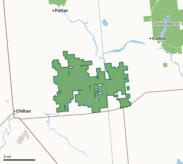
State wildlife areas, forests and other DNR landOther county, city and regional landKillsnake Wildlife AreaCounty lineLakeHighway
| Size | 7,008 acres in 4 pieces |
|---|---|
| Counties | Calumet County and Manitowoc County |
| Deer Management Unit | Calumet County, Manitowoc County |
| Public access (DNR) | Open to Hiking, Fishing, Hunting and Trapping |
| DNR property page | Killsnake Wildlife Area |
| Nearest towns | Collins (2 mi), Chilton (3 mi) and Potter (3 mi) |
What is Killsnake Wildlife Area like?
Killsnake Wildlife Area is located in both southeastern Calumet and southwestern Manitowoc counties. The property is approximately 7,000 acres and consists of a variety of open prairie grasslands, both upland and a large wetland-grassland complex, bottomland hardwood forest, a small area of cedar swamp, tamarack and bog, areas of upland forest with new areas of northern hardwood forest being planted and planned. Over 50 small wetland restorations, called brood ponds, for waterfowl production have been created or enhanced across the property. The heart of the property consists of the confluence of three rivers merging (South Branch-Manitowoc River, Cedar Creek and Killsnake River). To find Killsnake Wildlife Area, take Highway 57 to Chilton, then head east on Highway 151 for approximately 5 miles. Take a left on Lemke Road, heading north through the interior of the property.
In 1948, the Killsnake Bottoms and Cedar Creek area, which occupied about 4,500 acres within the present boundary, were set up as leased areas. The first land was purchased in 1956 in Manitowoc County, and in the mid-1960s, the property was expanded into Calumet County. The property was originally set up as a goose satellite area. Today, the property size is around 7,000 acres. Farming occurs on over 1,000 acres. Restorations of prairie on over 1,500 acres, along with small wetlands totaling over 50 sites, continue to add to the diversity of this property. Presently, prescribed burning for grasslands is maintained for a variety of wildlife, water management on small impoundments or ponds is controlled by manipulating water levels and agricultural fields are maintained for food production for humans and wildlife.
In the DNR's words, from its page for the property.
What are the rules on Killsnake Wildlife Area?
The DNR's property map lists Killsnake Wildlife Area as "Open to Hiking, Fishing, Hunting and Trapping". Hunting follows Wisconsin's statewide seasons and the rules posted on the property.
How many deer are taken around Killsnake Wildlife Area?
Killsnake Wildlife Area lies in 2 deer management units. The DNR registered 1,481 deer in Calumet County in 2025, against 1,371 in 2024.
| DMU | Killsnake Wildlife Area acres in it | Deer, 2025 | Deer, 2024 | Deer, 2023 |
|---|---|---|---|---|
| Calumet County | 5,308 | 1,481 | 1,371 | 1,318 |
| Manitowoc County | 1,699 | 4,513 | 4,262 | 4,130 |
Harvest for the whole deer management unit, not the property alone: Wisconsin DNR Deer Metrics (registered harvest by deer management unit).
How do you get to Killsnake Wildlife Area?
Nearest towns: Collins (2 miles), Chilton (3 miles), Potter (3 miles) and St. Nazianz (5 miles). Highways within 5 miles: US 151, WI 32, WI 57 and WI 67.
What other public land is near Killsnake Wildlife Area?
DNR properties within 10 miles:
- Collins Marsh Wildlife Area: 4,319 acres, 2.3 miles away
- Brillion Wildlife Area: 4,902 acres, 2.8 miles away
- Fox River State Trail: 292 acres, 5.4 miles away
- Kiel Marsh Wildlife Area: 851 acres, 7.7 miles away
- Stockbridge Ledge Woods State Natural Area: 42 acres, 8.3 miles away
Public land within 3 miles of Killsnake Wildlife Area
Counting Killsnake Wildlife Area itself, 7,935 of the 58,049 acres within 3 miles of its boundary are public land open to the public (13.7%), by USGS PAD-US 4.1 (fee land open to the public).
| Manager | Acres within 3 miles |
|---|---|
| State wildlife areas, forests and other DNR land | 7,708 |
| Other county, city and regional land | 227 |
Questions hunters ask
Where is Killsnake Wildlife Area?
In Calumet and Manitowoc counties, 2 miles from Collins. The DNR's property page has its maps and parking.
Is Killsnake Wildlife Area open to hunting?
Yes. The DNR's property map lists it as "Open to Hiking, Fishing, Hunting and Trapping". Posted refuges or closed areas, where there are any, are marked on site.
Which deer management unit is Killsnake Wildlife Area in?
Calumet County (5,308 acres) and Manitowoc County (1,699 acres).
How much public land is around Killsnake Wildlife Area?
7,935 acres within 3 miles of its boundary, Killsnake Wildlife Area included, by PAD-US 4.1. The closest other DNR property is Collins Marsh Wildlife Area (2.3 miles).
Get a Wisconsin hunt plan when they open
Hunt plans for Wisconsin are coming. Join the list and you'll hear first. The first 50 hunters in each new state get their plan free.
Until then, the free FilledTag app for iPhone has a map that works in every state, Wisconsin included.
Where these facts come from
- Area description, species, rules and directions: DNR, Killsnake Wildlife Area; Wisconsin DNR managed lands open to hunting.
- Boundary and acres: the DNR's map layer above. Surrounding public land: USGS PAD-US 4.1 (fee land open to the public).
- Deer harvest: Wisconsin DNR Deer Metrics (registered harvest by deer management unit).
FilledTag is not part of the Wisconsin Department of Natural Resources. Check the DNR's rules and posted signs before you go.
Wisconsin hunting Calumet County Manitowoc County Calumet County Manitowoc County