Lake Evelyn State Natural Area: hunting and access
Lake Evelyn State Natural Area is 244 acres of land managed by the Wisconsin DNR in Iron County, 7 miles from Mercer. Hunters registered 895 deer in DMU 117 in 2025.
Data updated October 2026. Area facts: the DNR's DNR property data, read 2026-10. Harvest: DNR Deer Metrics.
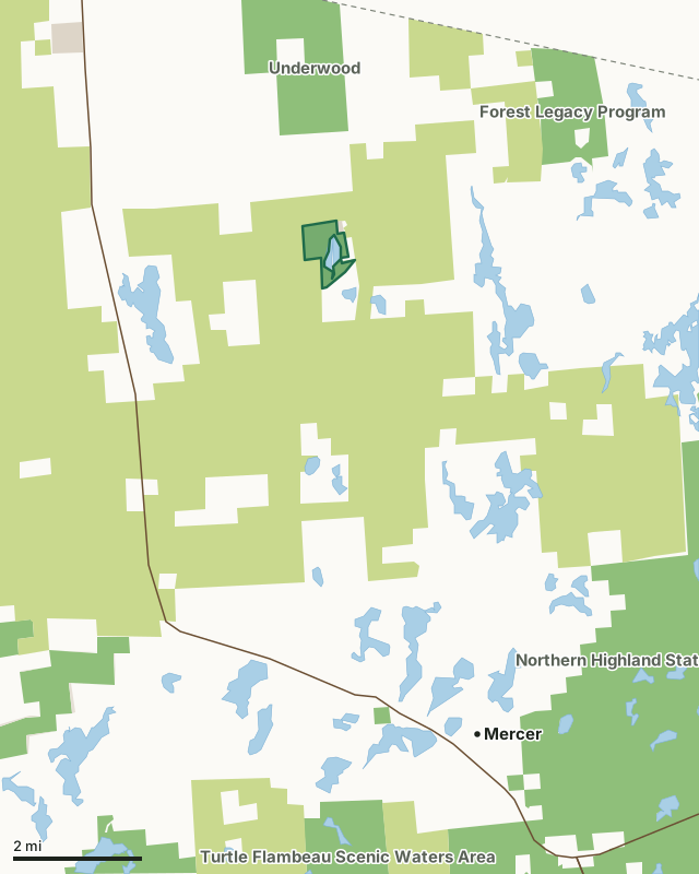
State wildlife areas, forests and other DNR landCounty forestOther county, city and regional landLand trusts and other open landLake Evelyn State Natural AreaCounty lineLakeHighway
| Size | 244 acres |
|---|---|
| County | Iron County |
| Deer Management Unit | DMU 117 |
| Public access (DNR) | Open to Hiking, Fishing, Hunting and Trapping |
| DNR property page | Lake Evelyn |
| Nearest towns | Mercer (7 mi), Pence (13 mi) and Hurley (13 mi) |
What is Lake Evelyn State Natural Area like?
Lake Evelyn is an undeveloped 55-acre soft-water seepage lake surrounded by wetlands and gently rolling uplands. While many northern Wisconsin lakes of this size are already developed or are planning development, Lake Evelyn is a rare and undeveloped wilderness lake. Of all lakes over 50 acres in Wisconsin, only 70 remain that have the majority of their shoreline in public ownership. With a maximum depth of 9 feet, Lake Evelyn is a stained water lake with moderate clarity and contains a good quality fishery composed mainly of large-mouthed bass and panfish. The lake forms the headwaters of Evelyn Creek, a tributary of the Turtle River. The topography is level to rolling and vegetation is a mix of large white and red pine with smaller pole-sized aspen on the uplands.
Iron County. T44N-R3E, Section 23, 26. 300 acres. Highway 51 and County Highway J in Mercer, go north on Highway 51 for 9.2 miles, then east on G for 4.5 miles, then north on North Bass Lake Road, then immediately west on a small access road 0.1 miles to a boat launch. Please note that ATVs are prohibited on the access road.
In the DNR's words, from its page for the property.
What are the rules on Lake Evelyn State Natural Area?
The DNR's property map lists Lake Evelyn State Natural Area as "Open to Hiking, Fishing, Hunting and Trapping". Hunting follows Wisconsin's statewide seasons and the rules posted on the property.
How many deer are taken around Lake Evelyn State Natural Area?
Lake Evelyn State Natural Area lies in DMU 117. The DNR registered 895 deer in DMU 117 in 2025.
| DMU | Lake Evelyn State Natural Area acres in it | Deer, 2025 |
|---|---|---|
| DMU 117 | 244 | 895 |
Harvest for the whole deer management unit, not the property alone: Wisconsin DNR Deer Metrics (registered harvest by deer management unit).
How do you get to Lake Evelyn State Natural Area?
Nearest towns: Mercer (7 miles), Pence (13 miles), Hurley (13 miles) and Montreal (13 miles). Highways within 5 miles: US 51.
What other public land is near Lake Evelyn State Natural Area?
DNR properties within 10 miles:
- Underwood Wildlife Area: 1,554 acres, 1.4 miles away
- Forest Legacy Program: 33,075 acres, 3.3 miles away
- Great Northern Conservation Easement: 14,010 acres, 5.3 miles away
- Northern Highland State Forest: 176,323 acres, 5.6 miles away
- Tomahawk Timberlands Conservation Easement (Moose Lake Trct): 3,017 acres, 5.9 miles away
- Moose Lake State Natural Area: 4,086 acres, 6.1 miles away
Public land within 3 miles of Lake Evelyn State Natural Area
Counting Lake Evelyn State Natural Area itself, 12,920 of the 24,063 acres within 3 miles of its boundary are public land open to the public (53.7%), by USGS PAD-US 4.1 (fee land open to the public).
| Manager | Acres within 3 miles |
|---|---|
| County forest | 11,544 |
| State wildlife areas, forests and other DNR land | 1,366 |
| Other county, city and regional land | 10 |
Questions hunters ask
Where is Lake Evelyn State Natural Area?
In Iron County, 7 miles from Mercer. The DNR's property page has its maps and parking.
Is Lake Evelyn State Natural Area open to hunting?
Yes. The DNR's property map lists it as "Open to Hiking, Fishing, Hunting and Trapping". Posted refuges or closed areas, where there are any, are marked on site.
Which deer management unit is Lake Evelyn State Natural Area in?
DMU 117.
How much public land is around Lake Evelyn State Natural Area?
12,920 acres within 3 miles of its boundary, Lake Evelyn State Natural Area included, by PAD-US 4.1. The closest other DNR property is Underwood Wildlife Area (1.4 miles).
Get a Wisconsin hunt plan when they open
Hunt plans for Wisconsin are coming. Join the list and you'll hear first. The first 50 hunters in each new state get their plan free.
Until then, the free FilledTag app for iPhone has a map that works in every state, Wisconsin included.
Where these facts come from
- Area description, species, rules and directions: DNR, Lake Evelyn State Natural Area; Wisconsin DNR managed lands open to hunting.
- Boundary and acres: the DNR's map layer above. Surrounding public land: USGS PAD-US 4.1 (fee land open to the public).
- Deer harvest: Wisconsin DNR Deer Metrics (registered harvest by deer management unit).
FilledTag is not part of the Wisconsin Department of Natural Resources. Check the DNR's rules and posted signs before you go.