Underwood Wildlife Area: hunting and access
Underwood Wildlife Area is 1,554 acres of land managed by the Wisconsin DNR in Iron County, 9 miles from Hurley. Hunters registered 895 deer in DMU 117 in 2025.
Data updated October 2026. Area facts: the DNR's DNR property data, read 2026-10. Harvest: DNR Deer Metrics.
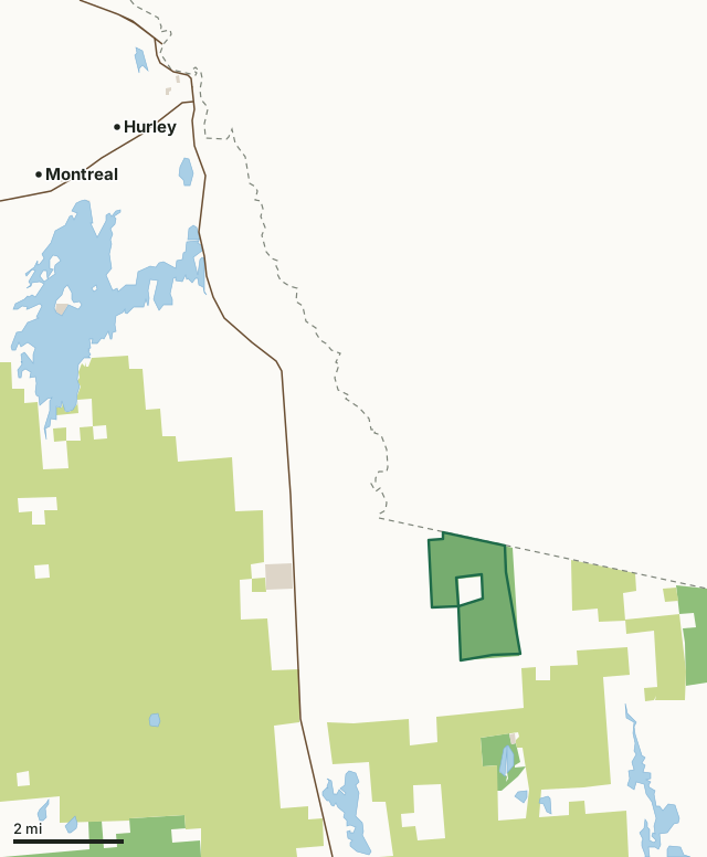
State wildlife areas, forests and other DNR landCounty forestOther county, city and regional landUnderwood Wildlife AreaCounty lineLakeHighway
| Size | 1,554 acres |
|---|---|
| County | Iron County |
| Deer Management Unit | DMU 117 |
| Public access (DNR) | Open to Hiking, Fishing, Hunting and Trapping |
| DNR property page | Underwood Wildlife Area |
| Nearest towns | Hurley (9 mi), Mercer (10 mi) and Pence (10 mi) |
What is Underwood Wildlife Area like?
Underwood Wildlife Area is a 1,602-acre property located in northeast Iron County. It was purchased by the Wisconsin Conservation Department (now the DNR) in the 1940s and 1950s to protect the area as a deer yard. Cedar and hemlock browse cutting for deer in the winters changed the area to be more dominated by hardwoods, reducing its suitability as a deer yard. Underwood Wildlife Area is located in northeast Iron County. Take Highway 51 for 9 miles north of Mercer to Highway G. Then go 4 miles east to Bass Lake Road. On Bass Lake Road, go north about 2.5 miles.
Current timber harvest is used to maintain aspen stands and an uneven aged northern hardwood forest. Grass openings were created in the 1980s and are maintained today. The DNR Wildlife and Forestry programs use this area to experiment with cedar, hemlock and oak regeneration. The Underwood Wildlife Area offers many recreational opportunities:.
In the DNR's words, from its page for the property.
What are the rules on Underwood Wildlife Area?
The DNR's property map lists Underwood Wildlife Area as "Open to Hiking, Fishing, Hunting and Trapping". Hunting follows Wisconsin's statewide seasons and the rules posted on the property.
Activities the DNR lists for Underwood Wildlife Area: Auto travel (road into the area may not be plowed in winter);, Biking;, Birding;, Cross-country skiing (no designated trail);, Hiking (no designated trail);, Hunting;, Trapping;, Wild edibles/gathering; and and Wildlife viewing.
How many deer are taken around Underwood Wildlife Area?
Underwood Wildlife Area lies in DMU 117. The DNR registered 895 deer in DMU 117 in 2025.
| DMU | Underwood Wildlife Area acres in it | Deer, 2025 |
|---|---|---|
| DMU 117 | 1,552 | 895 |
Harvest for the whole deer management unit, not the property alone: Wisconsin DNR Deer Metrics (registered harvest by deer management unit).
How do you get to Underwood Wildlife Area?
Nearest towns: Hurley (9 miles), Mercer (10 miles), Pence (10 miles) and Montreal (10 miles). Highways within 5 miles: US 51.
What other public land is near Underwood Wildlife Area?
DNR properties within 10 miles:
- Lake Evelyn State Natural Area: 244 acres, 1.4 miles away
- Forest Legacy Program: 33,075 acres, 3 miles away
- Great Northern Conservation Easement: 14,010 acres, 5.7 miles away
- Northern Highland State Forest: 176,323 acres, 6.6 miles away
- Moose Lake State Natural Area: 4,086 acres, 6.7 miles away
- Tomahawk Timberlands Conservation Easement (Moose Lake Trct): 3,017 acres, 6.9 miles away
Public land within 3 miles of Underwood Wildlife Area
Counting Underwood Wildlife Area itself, 8,631 of the 33,029 acres within 3 miles of its boundary are public land open to the public (26.1%), by USGS PAD-US 4.1 (fee land open to the public).
| Manager | Acres within 3 miles |
|---|---|
| County forest | 6,519 |
| State wildlife areas, forests and other DNR land | 1,962 |
| Other county, city and regional land | 150 |
Questions hunters ask
Where is Underwood Wildlife Area?
In Iron County, 9 miles from Hurley. The DNR's property page has its maps and parking.
Is Underwood Wildlife Area open to hunting?
Yes. The DNR's property map lists it as "Open to Hiking, Fishing, Hunting and Trapping". Posted refuges or closed areas, where there are any, are marked on site.
Which deer management unit is Underwood Wildlife Area in?
DMU 117.
How much public land is around Underwood Wildlife Area?
8,631 acres within 3 miles of its boundary, Underwood Wildlife Area included, by PAD-US 4.1. The closest other DNR property is Lake Evelyn State Natural Area (1.4 miles).
Get a Wisconsin hunt plan when they open
Hunt plans for Wisconsin are coming. Join the list and you'll hear first. The first 50 hunters in each new state get their plan free.
Until then, the free FilledTag app for iPhone has a map that works in every state, Wisconsin included.
Where these facts come from
- Area description, species, rules and directions: DNR, Underwood Wildlife Area; Wisconsin DNR managed lands open to hunting.
- Boundary and acres: the DNR's map layer above. Surrounding public land: USGS PAD-US 4.1 (fee land open to the public).
- Deer harvest: Wisconsin DNR Deer Metrics (registered harvest by deer management unit).
FilledTag is not part of the Wisconsin Department of Natural Resources. Check the DNR's rules and posted signs before you go.