Lawrence Lake State Natural Area: hunting and access
Lawrence Lake State Natural Area is 292 acres of land managed by the Wisconsin DNR in Langlade County, 11 miles from Antigo. Hunters registered 1,726 deer in DMU 123 in 2025.
Data updated October 2026. Area facts: the DNR's DNR property data, read 2026-10. Harvest: DNR Deer Metrics.
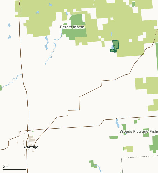
State wildlife areas, forests and other DNR landCounty forestOther county, city and regional landLawrence Lake State Natural AreaCounty lineLakeHighway
| Size | 292 acres |
|---|---|
| County | Langlade County |
| Deer Management Unit | DMU 123 |
| Public access (DNR) | Open to Hiking, Fishing, Hunting and Trapping |
| DNR property page | Lawrence Lake |
| Nearest towns | Antigo (11 mi), White Lake (12 mi) and Post Lake (12 mi) |
What is Lawrence Lake State Natural Area like?
Lawrence Lake features an undeveloped wild lake surrounded by northern wet-mesic forest, bog and shrubs. The 50-acre seepage lake has very soft, slightly acidic, clear water. The area surrounding the lake is comprised of relatively steep terrain. The shoreline is ringed by a broad band of mixed hardwoods and conifers. Species include hemlock, black spruce, balsam fir, aspen, sugar maple and red maple. The lake contains an expansive littoral zone with a well-developed aquatic plant community consisting of emergent, floating leaf, and submersed plants including cat-tails, bulrush, smartweeds and manna grass. This minimally disturbed area provides a habitat for many shorebirds, terrestrial and aquatic insects and aquatic and semi-aquatic furbearers. Three kettle depressions with shallow wetlands are located on the south shore of the lake.
If a developed trail is present, it will typically be noted on the SNA map and/or under the Maps tab. Entrance fees : For non-DNR-owned SNAs, we are unaware of any vehicle or admission fees. Other allowable activities, such as camping, geocaching and bicycling, are determined by the landowner. Please contact them directly or visit their websites for details. Within Langlade County Forest, Langlade County. T32N-R12E, Sections 10, 15. 326 acres.
In the DNR's words, from its page for the property.
What are the rules on Lawrence Lake State Natural Area?
The DNR's property map lists Lawrence Lake State Natural Area as "Open to Hiking, Fishing, Hunting and Trapping". Hunting follows Wisconsin's statewide seasons and the rules posted on the property.
How many deer are taken around Lawrence Lake State Natural Area?
Lawrence Lake State Natural Area lies in DMU 123. The DNR registered 1,726 deer in DMU 123 in 2025.
| DMU | Lawrence Lake State Natural Area acres in it | Deer, 2025 |
|---|---|---|
| DMU 123 | 292 | 1,726 |
Harvest for the whole deer management unit, not the property alone: Wisconsin DNR Deer Metrics (registered harvest by deer management unit).
How do you get to Lawrence Lake State Natural Area?
Nearest towns: Antigo (11 miles), White Lake (12 miles), Post Lake (12 miles) and Summit Lake (13 miles). Highways within 5 miles: WI 52.
What other public land is near Lawrence Lake State Natural Area?
DNR properties within 10 miles:
- Peters Marsh Wildlife Area: 1,772 acres, 2.3 miles away
- Upper Wolf River Fishery Area: 9,345 acres, 3.2 miles away
- Forest Legacy Program: 33,075 acres, 3.3 miles away
- Eau Claire River Fishery Area: 47 acres, 4.3 miles away
- Crystal Springs Rearing Station: 30 acres, 4.4 miles away
- Wolf River State Trail: 524 acres, 5.8 miles away
Public land within 3 miles of Lawrence Lake State Natural Area
Counting Lawrence Lake State Natural Area itself, 11,724 of the 24,467 acres within 3 miles of its boundary are public land open to the public (47.9%), by USGS PAD-US 4.1 (fee land open to the public).
| Manager | Acres within 3 miles |
|---|---|
| County forest | 11,120 |
| State wildlife areas, forests and other DNR land | 604 |
Questions hunters ask
Where is Lawrence Lake State Natural Area?
In Langlade County, 11 miles from Antigo. The DNR's property page has its maps and parking.
Is Lawrence Lake State Natural Area open to hunting?
Yes. The DNR's property map lists it as "Open to Hiking, Fishing, Hunting and Trapping". Posted refuges or closed areas, where there are any, are marked on site.
Which deer management unit is Lawrence Lake State Natural Area in?
DMU 123.
How much public land is around Lawrence Lake State Natural Area?
11,724 acres within 3 miles of its boundary, Lawrence Lake State Natural Area included, by PAD-US 4.1. The closest other DNR property is Peters Marsh Wildlife Area (2.3 miles).
Get a Wisconsin hunt plan when they open
Hunt plans for Wisconsin are coming. Join the list and you'll hear first. The first 50 hunters in each new state get their plan free.
Until then, the free FilledTag app for iPhone has a map that works in every state, Wisconsin included.
Where these facts come from
- Area description, species, rules and directions: DNR, Lawrence Lake State Natural Area; Wisconsin DNR managed lands open to hunting.
- Boundary and acres: the DNR's map layer above. Surrounding public land: USGS PAD-US 4.1 (fee land open to the public).
- Deer harvest: Wisconsin DNR Deer Metrics (registered harvest by deer management unit).
FilledTag is not part of the Wisconsin Department of Natural Resources. Check the DNR's rules and posted signs before you go.