Peters Marsh Wildlife Area: hunting and access
Peters Marsh Wildlife Area is 1,772 acres of land managed by the Wisconsin DNR in Langlade County, 9 miles from Summit Lake. Hunters registered 1,726 deer in DMU 123 in 2025.
Data updated October 2026. Area facts: the DNR's DNR property data, read 2026-10. Harvest: DNR Deer Metrics.
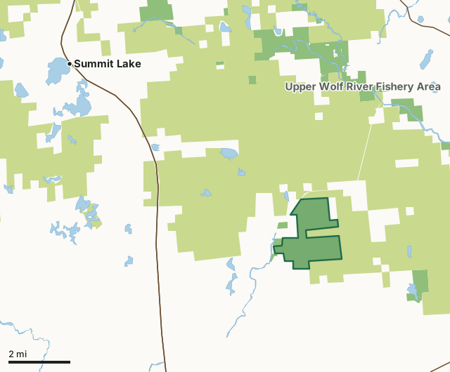
State wildlife areas, forests and other DNR landCounty forestPeters Marsh Wildlife AreaCounty lineLakeHighway
| Size | 1,772 acres |
|---|---|
| County | Langlade County |
| Deer Management Unit | DMU 123 |
| Public access (DNR) | Open to Hiking, Fishing, Hunting and Trapping |
| DNR property page | Peters Marsh Wildlife Area |
| Nearest towns | Summit Lake (9 mi), Post Lake (9 mi) and Antigo (10 mi) |
What is Peters Marsh Wildlife Area like?
Peters Marsh Wildlife Area covers 1,687 acres in central Langlade County. The property is made up of a variety of habitat types including forests, wetlands and native grasslands. The diversity of cover provides habitat for numerous wildlife species including waterfowl, ruffed grouse, deer, turkey, black bear, woodcock, snowshoe hare and beaver. The Ice Age Trail and Langlade County Snowmobile Trail pass through the property. Hunters, hikers and birdwatchers alike will enjoy all that this property has to offer. Located on County Highway A about 9 miles northeast of Antigo, multiple parking areas provide access to a network of grass walking trails.
Peters Marsh Wildlife Area has undergone many changes. During the late 1800s, this area was logged extensively for white pine and hemlock. During the 1930s, wildfires kept the new forest from maturing. As a result of these fires, early successional species such as aspen dominate the area. Modern forest management practices have maintained this timber type to this day. Wildlife openings are maintained through periodic mowing. The Peters Marsh Wildlife Area offers many recreational opportunities:. Download a map of this property. Map A [PDF] and Map B [PDF].
In the DNR's words, from its page for the property.
What are the rules on Peters Marsh Wildlife Area?
The DNR's property map lists Peters Marsh Wildlife Area as "Open to Hiking, Fishing, Hunting and Trapping". Hunting follows Wisconsin's statewide seasons and the rules posted on the property.
Activities the DNR lists for Peters Marsh Wildlife Area: Biking, Birding, Camping (open seasonally, rustic pull-in spots with no amenities), Canoeing, Cross-country skiing (no designated trail), Hiking (Ice Age Trail), Hunting, Kayaking, Snowmobiling trail, Trapping, Wild edibles/gathering and Wildlife viewing.
How many deer are taken around Peters Marsh Wildlife Area?
Peters Marsh Wildlife Area lies in DMU 123. The DNR registered 1,726 deer in DMU 123 in 2025.
| DMU | Peters Marsh Wildlife Area acres in it | Deer, 2025 |
|---|---|---|
| DMU 123 | 1,772 | 1,726 |
Harvest for the whole deer management unit, not the property alone: Wisconsin DNR Deer Metrics (registered harvest by deer management unit).
How do you get to Peters Marsh Wildlife Area?
Nearest towns: Summit Lake (9 miles), Post Lake (9 miles), Antigo (10 miles) and Elcho (11 miles). Highways within 5 miles: WI 52, US 45 and WI 47.
What other public land is near Peters Marsh Wildlife Area?
DNR properties within 10 miles:
- Eau Claire River Fishery Area: 47 acres, next to it
- Crystal Springs Rearing Station: 30 acres, next to it
- Lawrence Lake State Natural Area: 292 acres, 2.3 miles away
- Upper Wolf River Fishery Area: 9,345 acres, 3.3 miles away
- Forest Legacy Program: 33,075 acres, 6.1 miles away
- Knoke Spring State Spring Ponds: 21 acres, 6.4 miles away
Public land within 3 miles of Peters Marsh Wildlife Area
Counting Peters Marsh Wildlife Area itself, 19,382 of the 34,417 acres within 3 miles of its boundary are public land open to the public (56.3%), by USGS PAD-US 4.1 (fee land open to the public).
| Manager | Acres within 3 miles |
|---|---|
| County forest | 17,215 |
| State wildlife areas, forests and other DNR land | 2,167 |
Questions hunters ask
Where is Peters Marsh Wildlife Area?
In Langlade County, 9 miles from Summit Lake. The DNR's property page has its maps and parking.
Is Peters Marsh Wildlife Area open to hunting?
Yes. The DNR's property map lists it as "Open to Hiking, Fishing, Hunting and Trapping". Posted refuges or closed areas, where there are any, are marked on site.
Which deer management unit is Peters Marsh Wildlife Area in?
DMU 123.
How much public land is around Peters Marsh Wildlife Area?
19,382 acres within 3 miles of its boundary, Peters Marsh Wildlife Area included, by PAD-US 4.1. The closest other DNR property is Eau Claire River Fishery Area (next to it).
Get a Wisconsin hunt plan when they open
Hunt plans for Wisconsin are coming. Join the list and you'll hear first. The first 50 hunters in each new state get their plan free.
Until then, the free FilledTag app for iPhone has a map that works in every state, Wisconsin included.
Where these facts come from
- Area description, species, rules and directions: DNR, Peters Marsh Wildlife Area; Wisconsin DNR managed lands open to hunting.
- Boundary and acres: the DNR's map layer above. Surrounding public land: USGS PAD-US 4.1 (fee land open to the public).
- Deer harvest: Wisconsin DNR Deer Metrics (registered harvest by deer management unit).
FilledTag is not part of the Wisconsin Department of Natural Resources. Check the DNR's rules and posted signs before you go.