Lunch Creek Wetlands State Natural Area: hunting and access
Lunch Creek Wetlands State Natural Area is 214 acres of land managed by the Wisconsin DNR in Waushara County, 3 miles from Wautoma. Hunters registered 8,678 deer in Waushara County in 2025.
Data updated October 2026. Area facts: the DNR's DNR property data, read 2026-10. Harvest: DNR Deer Metrics.
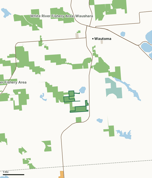
State wildlife areas, forests and other DNR landNational wildlife refuges and waterfowl production areasOther county, city and regional landLand trusts and other open landVoluntary Public Access landLunch Creek Wetlands State Natural AreaCounty lineLakeHighway
| Size | 214 acres in 4 pieces |
|---|---|
| County | Waushara County |
| Deer Management Unit | Waushara County |
| Public access (DNR) | Open to Hiking, Fishing, Hunting and Trapping |
| DNR property page | Lunch Creek Wetlands |
| Nearest towns | Wautoma (3 mi), Neshkoro (6 mi) and Lohrville (9 mi) |
What is Lunch Creek Wetlands State Natural Area like?
Lunch Creek Wetlands contains one of the most diverse and species-rich sedge meadows in Wisconsin situated within a mainly undisturbed watershed, an uncommon occurrence in Wisconsin. This large wetland complex is free of exotic species and dominated by fen and sedge meadow communities containing a total of 115 plant species. Many uncommon species are present including fringed gentian, Kalm's lobelia and grass-of-Parnassus. Wetland air photos show patterning, a rare phenomenon seen at Cedarburg Bog and Bogus Swamp natural areas. The patterning is evident on the ground where high and low areas often show dramatic differences in plant species presence with wire grass sedges found in lower "impoundment" areas and a forb-dominated sedge meadow directly adjacent to it. A fen-like meadow emanates from the uplands and upland islands surrounding the lower areas.
Waushara County. T18N-R10E, Sections 16, 17, 21, 22. 609 acres. From the intersection of Highways 73 and 21 in Wautoma, go south and west on 21 for 2.6 miles, then south on County Y for about 2.0 miles to a DNR parking area east of the road. Follow Lunch Creek downstream to the wetlands.
In the DNR's words, from its page for the property.
What are the rules on Lunch Creek Wetlands State Natural Area?
The DNR's property map lists Lunch Creek Wetlands State Natural Area as "Open to Hiking, Fishing, Hunting and Trapping". Hunting follows Wisconsin's statewide seasons and the rules posted on the property.
How many deer are taken around Lunch Creek Wetlands State Natural Area?
Lunch Creek Wetlands State Natural Area lies in Waushara County. The DNR registered 8,678 deer in Waushara County in 2025, against 8,191 in 2024.
| DMU | Lunch Creek Wetlands State Natural Area acres in it | Deer, 2025 | Deer, 2024 | Deer, 2023 |
|---|---|---|---|---|
| Waushara County | 214 | 8,678 | 8,191 | 6,404 |
Harvest for the whole deer management unit, not the property alone: Wisconsin DNR Deer Metrics (registered harvest by deer management unit).
How do you get to Lunch Creek Wetlands State Natural Area?
Nearest towns: Wautoma (3 miles), Neshkoro (6 miles), Lohrville (9 miles) and Redgranite (9 miles). Highways within 5 miles: WI 21, WI 22, WI 73 and WI 152. 1 VPA property within 3 miles.
What other public land is near Lunch Creek Wetlands State Natural Area?
DNR properties within 10 miles:
- White River Fishery Area-Waushara: 3,501 acres, next to it
- Mecan River Fishery Area: 6,730 acres, 0.7 miles away
- Bass Lake Fen State Natural Area: 103 acres, 0.9 miles away
- White River Marsh Wildlife Area: 12,706 acres, 6.5 miles away
- Germania Wildlife Area: 2,416 acres, 7 miles away
- State Ice Age Trail Area (SIATA): 4,676 acres, 7 miles away
Public land within 3 miles of Lunch Creek Wetlands State Natural Area
Counting Lunch Creek Wetlands State Natural Area itself, 3,083 of the 25,481 acres within 3 miles of its boundary are public land open to the public (12.1%), by USGS PAD-US 4.1 (fee land open to the public).
| Manager | Acres within 3 miles |
|---|---|
| State wildlife areas, forests and other DNR land | 2,778 |
| National wildlife refuges and waterfowl production areas | 268 |
| Other county, city and regional land | 35 |
| Land trusts and other open land | 2 |
Questions hunters ask
Where is Lunch Creek Wetlands State Natural Area?
In Waushara County, 3 miles from Wautoma. The DNR's property page has its maps and parking.
Is Lunch Creek Wetlands State Natural Area open to hunting?
Yes. The DNR's property map lists it as "Open to Hiking, Fishing, Hunting and Trapping". Posted refuges or closed areas, where there are any, are marked on site.
Which deer management unit is Lunch Creek Wetlands State Natural Area in?
Waushara County.
How much public land is around Lunch Creek Wetlands State Natural Area?
3,083 acres within 3 miles of its boundary, Lunch Creek Wetlands State Natural Area included, by PAD-US 4.1. The closest other DNR property is White River Fishery Area-Waushara (next to it).
Get a Wisconsin hunt plan when they open
Hunt plans for Wisconsin are coming. Join the list and you'll hear first. The first 50 hunters in each new state get their plan free.
Until then, the free FilledTag app for iPhone has a map that works in every state, Wisconsin included.
Where these facts come from
- Area description, species, rules and directions: DNR, Lunch Creek Wetlands State Natural Area; Wisconsin DNR managed lands open to hunting.
- Boundary and acres: the DNR's map layer above. Surrounding public land: USGS PAD-US 4.1 (fee land open to the public).
- Deer harvest: Wisconsin DNR Deer Metrics (registered harvest by deer management unit).
FilledTag is not part of the Wisconsin Department of Natural Resources. Check the DNR's rules and posted signs before you go.