White River Fishery Area-Waushara: hunting and access
White River Fishery Area-Waushara is 3,501 acres of land managed by the Wisconsin DNR in Waushara County, next to Wautoma. Hunters registered 8,678 deer in Waushara County in 2025.
Data updated October 2026. Area facts: the DNR's DNR property data, read 2026-10. Harvest: DNR Deer Metrics.
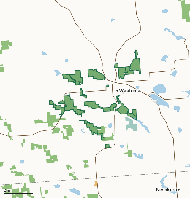
State wildlife areas, forests and other DNR landNational wildlife refuges and waterfowl production areasOther county, city and regional landLand trusts and other open landVoluntary Public Access landWhite River Fishery Area-WausharaCounty lineLakeHighway
| Size | 3,501 acres in 25 pieces |
|---|---|
| County | Waushara County |
| Deer Management Unit | Waushara County |
| Public access (DNR) | Open to Hiking, Fishing, Hunting and Trapping |
| DNR property page | White River Fishery Area (Waushara County) |
| Nearest towns | Wautoma (next to it), Wild Rose (5 mi) and Neshkoro (6 mi) |
What is White River Fishery Area-Waushara like?
The White River System Fishery Area includes some of the choicest trout waters found anywhere in the State of Wisconsin. The streams on this system are renowned for their ability to provide quality trout angling year after year and the fact that they are among the few trout streams in all of Wisconsin where a naturally reproducing population of rainbow trout exists. The White River Fishery Area is composed of the White River and four tributaries: Soules Creek, Lunch Creek, Bowers Creek, and the West Branch of the White River. These streams are high-quality trout waters. The water is generally crystal clear. The Main Branch of the White River is the largest stream within the system, and each of the other streams ultimately flows into it on its passage to the Fox River, a major stream on the Lake Michigan watershed.
Soules Creek flows into the Wautoma Pond, but the stream flowing from the pond is known as the Main Branch, White River. It flows south and east, picking up the combined Bird and Bowers, Mud and West Branch streams in turn before it flows into Dahlke Flowage. Lunch Creek flows into the Main Branch after it flows from Dahlke Flowage and before it flows into Neshkoro Pond, outside of the fishery area. Soules Creek is the headwaters of the Main Branch of the White River. It originates as a series of spring feeders northeast of the City of Wautoma. Lunch Creek is a cold water trout stream that flows into the Lower White River Mill pond. Lunch Creek has several springs and tributaries that maintain thermal stability and high oxygen content. In addition, the tributaries serve as important spawning and nursery areas for trout.
In the DNR's words, from its page for the property.
What are the rules on White River Fishery Area-Waushara?
The DNR's property map lists White River Fishery Area-Waushara as "Open to Hiking, Fishing, Hunting and Trapping". Hunting follows Wisconsin's statewide seasons and the rules posted on the property.
Activities the DNR lists for White River Fishery Area-Waushara: Hunting, Trapping, Hiking, Snowmobiling - (designated areas only) and Wildlife viewing.
How many deer are taken around White River Fishery Area-Waushara?
White River Fishery Area-Waushara lies in Waushara County. The DNR registered 8,678 deer in Waushara County in 2025, against 8,191 in 2024.
| DMU | White River Fishery Area-Waushara acres in it | Deer, 2025 | Deer, 2024 | Deer, 2023 |
|---|---|---|---|---|
| Waushara County | 3,501 | 8,678 | 8,191 | 6,404 |
Harvest for the whole deer management unit, not the property alone: Wisconsin DNR Deer Metrics (registered harvest by deer management unit).
How do you get to White River Fishery Area-Waushara?
Nearest towns: Wautoma (next to it), Wild Rose (5 miles), Neshkoro (6 miles) and Lohrville (7 miles). Highways within 5 miles: WI 22, WI 21, WI 73 and WI 152. 1 VPA property within 3 miles.
What other public land is near White River Fishery Area-Waushara?
DNR properties within 10 miles:
- Mecan River Fishery Area: 6,730 acres, next to it
- Lunch Creek Wetlands State Natural Area: 214 acres, next to it
- Bass Lake Fen State Natural Area: 103 acres, 1.1 miles away
- Willow Creek Fishery Area: 2,864 acres, 3.4 miles away
- State Ice Age Trail Area (SIATA): 4,676 acres, 3.7 miles away
- Pine River System Fishery Area: 2,085 acres, 4.7 miles away
Public land within 3 miles of White River Fishery Area-Waushara
Counting White River Fishery Area-Waushara itself, 5,680 of the 73,087 acres within 3 miles of its boundary are public land open to the public (7.8%), by USGS PAD-US 4.1 (fee land open to the public).
| Manager | Acres within 3 miles |
|---|---|
| State wildlife areas, forests and other DNR land | 5,371 |
| National wildlife refuges and waterfowl production areas | 268 |
| Other county, city and regional land | 36 |
| Land trusts and other open land | 5 |
Questions hunters ask
Where is White River Fishery Area-Waushara?
In Waushara County, next to Wautoma. The DNR's property page has its maps and parking.
Is White River Fishery Area-Waushara open to hunting?
Yes. The DNR's property map lists it as "Open to Hiking, Fishing, Hunting and Trapping". Posted refuges or closed areas, where there are any, are marked on site.
Which deer management unit is White River Fishery Area-Waushara in?
Waushara County.
How much public land is around White River Fishery Area-Waushara?
5,680 acres within 3 miles of its boundary, White River Fishery Area-Waushara included, by PAD-US 4.1. The closest other DNR property is Mecan River Fishery Area (next to it).
Get a Wisconsin hunt plan when they open
Hunt plans for Wisconsin are coming. Join the list and you'll hear first. The first 50 hunters in each new state get their plan free.
Until then, the free FilledTag app for iPhone has a map that works in every state, Wisconsin included.
Where these facts come from
- Area description, species, rules and directions: DNR, White River Fishery Area-Waushara; Wisconsin DNR managed lands open to hunting.
- Boundary and acres: the DNR's map layer above. Surrounding public land: USGS PAD-US 4.1 (fee land open to the public).
- Deer harvest: Wisconsin DNR Deer Metrics (registered harvest by deer management unit).
FilledTag is not part of the Wisconsin Department of Natural Resources. Check the DNR's rules and posted signs before you go.