Richard A Hemp Fishery Area: hunting and access
Richard A Hemp Fishery Area is 1,401 acres of land managed by the Wisconsin DNR in Portage County, next to Nelsonville. Hunters registered 8,384 deer in Portage County in 2025.
Data updated October 2026. Area facts: the DNR's DNR property data, read 2026-10. Harvest: DNR Deer Metrics.
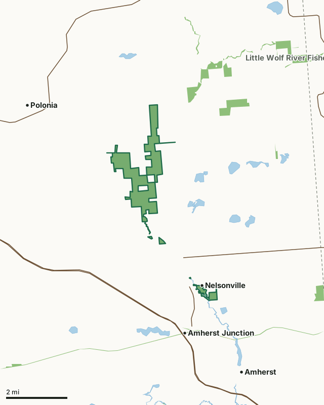
State wildlife areas, forests and other DNR landState parksLand trusts and other open landRichard A Hemp Fishery AreaCounty lineLakeHighway
| Size | 1,401 acres in 8 pieces |
|---|---|
| County | Portage County |
| Deer Management Unit | Portage County |
| Public access (DNR) | Open to Hiking, Fishing, Hunting and Trapping |
| DNR property page | Richard A Hemp Fishery Area |
| Nearest towns | Nelsonville (next to it), Amherst Junction (next to it) and Amherst (2 mi) |
What is Richard A Hemp Fishery Area like?
The Richard A Hemp Fishery Area is a 1,372-acre property in Portage County. The property consists of a trout stream corridor, lowland forest (swamp conifer and bottomland hardwoods), and mixed hardwood forest. Richard A Hemp Fishery Area starts at Rolling Hills Road (County Hwy Q) north of Nelsonville and continues north to County Hwy Z. Numerous access sites are available.
Richard A Hemp Fishery Area is managed for in-stream fish and riparian buffer habitat. Property Manager Department of Natural Resources 225051 Rib Mountain Drive Wausau, WI 54401 (715) 679-0678. Fisheries Biologist Department of Natural Resources 225051 Rib Mountain Drive Wausau, WI 54401 (715) 679-0678.
In the DNR's words, from its page for the property.
What are the rules on Richard A Hemp Fishery Area?
The DNR's property map lists Richard A Hemp Fishery Area as "Open to Hiking, Fishing, Hunting and Trapping". Hunting follows Wisconsin's statewide seasons and the rules posted on the property.
Activities the DNR lists for Richard A Hemp Fishery Area: Hunting, Trapping, Hiking, Snowmobiling trail, Cross-country skiing, Wildlife viewing, Fishing - brown and brook trout, Bird watching, Swimming, Berry picking and Canoeing.
How many deer are taken around Richard A Hemp Fishery Area?
Richard A Hemp Fishery Area lies in Portage County. The DNR registered 8,384 deer in Portage County in 2025, against 7,641 in 2024.
| DMU | Richard A Hemp Fishery Area acres in it | Deer, 2025 | Deer, 2024 | Deer, 2023 |
|---|---|---|---|---|
| Portage County | 1,401 | 8,384 | 7,641 | 6,559 |
Harvest for the whole deer management unit, not the property alone: Wisconsin DNR Deer Metrics (registered harvest by deer management unit).
How do you get to Richard A Hemp Fishery Area?
Nearest towns: Nelsonville (next to it), Amherst Junction (next to it), Amherst (2 miles) and Polonia (3 miles). Highways within 5 miles: US 10, WI 66, WI 161 and WI 49.
What other public land is near Richard A Hemp Fishery Area?
DNR properties within 10 miles:
- Tomorrow River State Trail: 376 acres, 1 mile away
- Little Wolf River Fishery Area: 2,695 acres, 1 mile away
- New Hope Pines State Natural Area: 171 acres, 1.7 miles away
- State Ice Age Trail Area (SIATA): 4,676 acres, 3.3 miles away
- Trout-Nace Creek Fishery Area: 169 acres, 4.7 miles away
Public land within 3 miles of Richard A Hemp Fishery Area
Counting Richard A Hemp Fishery Area itself, 1,954 of the 52,421 acres within 3 miles of its boundary are public land open to the public (3.7%), by USGS PAD-US 4.1 (fee land open to the public).
| Manager | Acres within 3 miles |
|---|---|
| State wildlife areas, forests and other DNR land | 1,947 |
| State parks | 4 |
| Land trusts and other open land | 3 |
Questions hunters ask
Where is Richard A Hemp Fishery Area?
In Portage County, next to Nelsonville. The DNR's property page has its maps and parking.
Is Richard A Hemp Fishery Area open to hunting?
Yes. The DNR's property map lists it as "Open to Hiking, Fishing, Hunting and Trapping". Posted refuges or closed areas, where there are any, are marked on site.
Which deer management unit is Richard A Hemp Fishery Area in?
Portage County.
How much public land is around Richard A Hemp Fishery Area?
1,954 acres within 3 miles of its boundary, Richard A Hemp Fishery Area included, by PAD-US 4.1. The closest other DNR property is Tomorrow River State Trail (1 mile).
Get a Wisconsin hunt plan when they open
Hunt plans for Wisconsin are coming. Join the list and you'll hear first. The first 50 hunters in each new state get their plan free.
Until then, the free FilledTag app for iPhone has a map that works in every state, Wisconsin included.
Where these facts come from
- Area description, species, rules and directions: DNR, Richard A Hemp Fishery Area; Wisconsin DNR managed lands open to hunting.
- Boundary and acres: the DNR's map layer above. Surrounding public land: USGS PAD-US 4.1 (fee land open to the public).
- Deer harvest: Wisconsin DNR Deer Metrics (registered harvest by deer management unit).
FilledTag is not part of the Wisconsin Department of Natural Resources. Check the DNR's rules and posted signs before you go.