New Hope Pines State Natural Area: hunting and access
New Hope Pines State Natural Area is 171 acres of land managed by the Wisconsin DNR in Portage County, 4 miles from Rosholt. Hunters registered 8,384 deer in Portage County in 2025.
Data updated October 2026. Area facts: the DNR's DNR property data, read 2026-10. Harvest: DNR Deer Metrics.
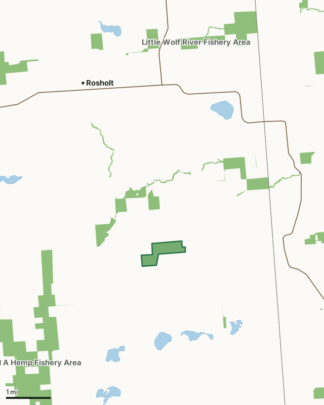
State wildlife areas, forests and other DNR landLand trusts and other open landNew Hope Pines State Natural AreaCounty lineLakeHighway
| Size | 171 acres |
|---|---|
| County | Portage County |
| Deer Management Unit | Portage County |
| Public access (DNR) | Open to Hiking, Fishing, Hunting and Trapping |
| DNR property page | New Hope Pines |
| Nearest towns | Rosholt (4 mi), Nelsonville (6 mi) and Polonia (6 mi) |
What is New Hope Pines State Natural Area like?
New Hope Pines features one of the largest and least disturbed northern dry-mesic forests remaining in central Wisconsin and is reminiscent of the vast "pineries" found in this region before settlement. A forest of red oak, white oak, and red maple stands beneath the canopy of white and red pines. Though the stand is relatively "young" with only scattered old growth, the dominant white pines are more than 100 feet high and up to two feet in diameter. Shrubs include American hazelnut, northern bush honeysuckle and round-leaved dogwood. Common ground layer species include bracken fern, wild sarsaparilla, American starflower, large-flowered trillium, Canada mayflower, partridgeberry, and big-leaved aster. The site lies on steep, irregular topography in ground moraine - a legacy of the last glacier. Two small kettle depressions contain sedge meadow and emergent aquatic species in wet years.
Portage County. T24N-R10E, Section 10. 171 acres. From the intersection of State Highway 66 and County Highway A just east of Rosholt, go south on A for 1.5 miles, then east and south on County Highway T for 1.3 miles, then south on Sunset Lake Road for 1.5 miles to a parking area west of the road.
In the DNR's words, from its page for the property.
What are the rules on New Hope Pines State Natural Area?
The DNR's property map lists New Hope Pines State Natural Area as "Open to Hiking, Fishing, Hunting and Trapping". Hunting follows Wisconsin's statewide seasons and the rules posted on the property.
How many deer are taken around New Hope Pines State Natural Area?
New Hope Pines State Natural Area lies in Portage County. The DNR registered 8,384 deer in Portage County in 2025, against 7,641 in 2024.
| DMU | New Hope Pines State Natural Area acres in it | Deer, 2025 | Deer, 2024 | Deer, 2023 |
|---|---|---|---|---|
| Portage County | 171 | 8,384 | 7,641 | 6,559 |
Harvest for the whole deer management unit, not the property alone: Wisconsin DNR Deer Metrics (registered harvest by deer management unit).
How do you get to New Hope Pines State Natural Area?
Nearest towns: Rosholt (4 miles), Nelsonville (6 miles), Polonia (6 miles) and Amherst Junction (7 miles). Highways within 5 miles: WI 49, WI 161 and WI 66.
What other public land is near New Hope Pines State Natural Area?
DNR properties within 10 miles:
- Little Wolf River Fishery Area: 2,695 acres, 0.8 miles away
- State Ice Age Trail Area (SIATA): 4,676 acres, 1.5 miles away
- Richard A Hemp Fishery Area: 1,401 acres, 1.7 miles away
- Trout-Nace Creek Fishery Area: 169 acres, 4.2 miles away
- Little Wolf River State Natural Area: 162 acres, 4.5 miles away
Public land within 3 miles of New Hope Pines State Natural Area
Counting New Hope Pines State Natural Area itself, 1,201 of the 23,278 acres within 3 miles of its boundary are public land open to the public (5.2%), by USGS PAD-US 4.1 (fee land open to the public).
| Manager | Acres within 3 miles |
|---|---|
| State wildlife areas, forests and other DNR land | 1,201 |
Questions hunters ask
Where is New Hope Pines State Natural Area?
In Portage County, 4 miles from Rosholt. The DNR's property page has its maps and parking.
Is New Hope Pines State Natural Area open to hunting?
Yes. The DNR's property map lists it as "Open to Hiking, Fishing, Hunting and Trapping". Posted refuges or closed areas, where there are any, are marked on site.
Which deer management unit is New Hope Pines State Natural Area in?
Portage County.
How much public land is around New Hope Pines State Natural Area?
1,201 acres within 3 miles of its boundary, New Hope Pines State Natural Area included, by PAD-US 4.1. The closest other DNR property is Little Wolf River Fishery Area (0.8 miles).
Get a Wisconsin hunt plan when they open
Hunt plans for Wisconsin are coming. Join the list and you'll hear first. The first 50 hunters in each new state get their plan free.
Until then, the free FilledTag app for iPhone has a map that works in every state, Wisconsin included.
Where these facts come from
- Area description, species, rules and directions: DNR, New Hope Pines State Natural Area; Wisconsin DNR managed lands open to hunting.
- Boundary and acres: the DNR's map layer above. Surrounding public land: USGS PAD-US 4.1 (fee land open to the public).
- Deer harvest: Wisconsin DNR Deer Metrics (registered harvest by deer management unit).
FilledTag is not part of the Wisconsin Department of Natural Resources. Check the DNR's rules and posted signs before you go.