Little Wolf River State Natural Area: hunting and access
Little Wolf River State Natural Area is 162 acres of land managed by the Wisconsin DNR in Waupaca County, 5 miles from Rosholt. Hunters registered 10,740 deer in Waupaca County in 2025.
Data updated October 2026. Area facts: the DNR's DNR property data, read 2026-10. Harvest: DNR Deer Metrics.
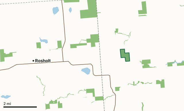
State wildlife areas, forests and other DNR landLittle Wolf River State Natural AreaCounty lineLakeHighway
| Size | 162 acres in 2 pieces |
|---|---|
| County | Waupaca County |
| Deer Management Unit | Waupaca County |
| Public access (DNR) | Open to Hiking, Fishing, Hunting and Trapping |
| DNR property page | Little Wolf River |
| Nearest towns | Rosholt (5 mi), Big Falls (8 mi) and Iola (9 mi) |
What is Little Wolf River State Natural Area like?
Little Wolf River contains an unaltered stretch of the Little Wolf River and its springs, seeps, and tributaries that traverse the area. A narrow corridor of floodplain sedge meadow and black ash swamp flanks the river. At this location, the Little Wolf River is a high-quality trout stream running fast and clear. The site also harbors an unfragmented block of northern wet-mesic forest dominated by white cedar with balsam fir, yellow birch, hemlock, and American elm. Numerous large boulders are strewn about the area. The ground flora is lush and dense with several species more typical of southern Wisconsin forested communities. Common species include lady fern, bulblet fern, Jack-in-the-pulpit, wild sarsaparilla, Michigan lily, alpine enchanter's nightshade, and several sedges.
Old cut and burned hemlock stumps indicate the area may have been impacted during the original logging era but is regenerating well today. Birds include broad-winged hawks, great-horned owls, great blue herons, black-billed cuckoos, ovenbird, and winter wren. The property was donated to the DNR by Jerry and Jill Martin. Little Wolf River is owned by the DNR and was designated a State Natural Area in 2002. Waupaca County. T25N-R11E, Section 20. 161 acres. The natural is only accessible at this time by water via the Little Wolf River. From the junction of Main Street and Highway 66 in Rosholt, go east on Highway 66 for 2 miles, then east on Highway 49 for 0.3 miles, then north and east on County Highway NN for 2.7 miles, then north on County Highway P for 0.25 miles, then east on Wolf River Road 1.5 miles to the bridge spanning the Little Wolf River.
In the DNR's words, from its page for the property.
What are the rules on Little Wolf River State Natural Area?
The DNR's property map lists Little Wolf River State Natural Area as "Open to Hiking, Fishing, Hunting and Trapping". Hunting follows Wisconsin's statewide seasons and the rules posted on the property.
How many deer are taken around Little Wolf River State Natural Area?
Little Wolf River State Natural Area lies in Waupaca County. The DNR registered 10,740 deer in Waupaca County in 2025, against 10,349 in 2024.
| DMU | Little Wolf River State Natural Area acres in it | Deer, 2025 | Deer, 2024 | Deer, 2023 |
|---|---|---|---|---|
| Waupaca County | 162 | 10,740 | 10,349 | 9,097 |
Harvest for the whole deer management unit, not the property alone: Wisconsin DNR Deer Metrics (registered harvest by deer management unit).
How do you get to Little Wolf River State Natural Area?
Nearest towns: Rosholt (5 miles), Big Falls (8 miles), Iola (9 miles) and Tigerton (10 miles). Highways within 5 miles: WI 49 and WI 66.
What other public land is near Little Wolf River State Natural Area?
DNR properties within 10 miles:
- Little Wolf River Fishery Area: 2,695 acres, next to it
- State Ice Age Trail Area (SIATA): 4,676 acres, 1.5 miles away
- Mud Lake Bog State Natural Area: 155 acres, 4.2 miles away
- New Hope Pines State Natural Area: 171 acres, 4.5 miles away
Public land within 3 miles of Little Wolf River State Natural Area
Counting Little Wolf River State Natural Area itself, 1,668 of the 23,420 acres within 3 miles of its boundary are public land open to the public (7.1%), by USGS PAD-US 4.1 (fee land open to the public).
| Manager | Acres within 3 miles |
|---|---|
| State wildlife areas, forests and other DNR land | 1,668 |
Questions hunters ask
Where is Little Wolf River State Natural Area?
In Waupaca County, 5 miles from Rosholt. The DNR's property page has its maps and parking.
Is Little Wolf River State Natural Area open to hunting?
Yes. The DNR's property map lists it as "Open to Hiking, Fishing, Hunting and Trapping". Posted refuges or closed areas, where there are any, are marked on site.
Which deer management unit is Little Wolf River State Natural Area in?
Waupaca County.
How much public land is around Little Wolf River State Natural Area?
1,668 acres within 3 miles of its boundary, Little Wolf River State Natural Area included, by PAD-US 4.1. The closest other DNR property is Little Wolf River Fishery Area (next to it).
Get a Wisconsin hunt plan when they open
Hunt plans for Wisconsin are coming. Join the list and you'll hear first. The first 50 hunters in each new state get their plan free.
Until then, the free FilledTag app for iPhone has a map that works in every state, Wisconsin included.
Where these facts come from
- Area description, species, rules and directions: DNR, Little Wolf River State Natural Area; Wisconsin DNR managed lands open to hunting.
- Boundary and acres: the DNR's map layer above. Surrounding public land: USGS PAD-US 4.1 (fee land open to the public).
- Deer harvest: Wisconsin DNR Deer Metrics (registered harvest by deer management unit).
FilledTag is not part of the Wisconsin Department of Natural Resources. Check the DNR's rules and posted signs before you go.