Little Wolf River Fishery Area: hunting and access
Little Wolf River Fishery Area is 2,695 acres of land managed by the Wisconsin DNR in Portage and Waupaca counties, next to Big Falls. The DNR's page for it names deer, wild turkey, ducks and geese, ruffed grouse, woodcock, bear and rabbits and squirrels among the game here. Hunters registered 8,384 deer in Portage County in 2025.
Data updated October 2026. Area facts: the DNR's DNR property data, read 2026-10. Harvest: DNR Deer Metrics.
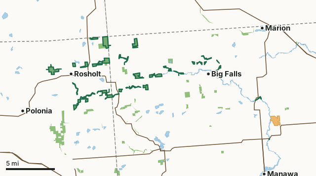
State wildlife areas, forests and other DNR landVoluntary Public Access landLittle Wolf River Fishery AreaCounty lineLakeHighway
| Size | 2,695 acres in 56 pieces |
|---|---|
| Counties | Portage County and Waupaca County |
| Deer Management Unit | Portage County, Waupaca County |
| DNR lists for hunting | deer, wild turkey, ducks and geese, ruffed grouse, woodcock, bear and rabbits and squirrels |
| Public access (DNR) | Open to Hiking, Fishing, Hunting and Trapping |
| DNR property page | Little Wolf River Fishery Area |
| Nearest towns | Big Falls (next to it), Rosholt (next to it) and Manawa (4 mi) |
What is Little Wolf River Fishery Area like?
The Little Wolf River Fishery Area is located in the Forest Transition Ecological Landscape of northeastern Portage and northwestern Waupaca Counties. Major landcover types include 382 acres aspen, 237 acres white cedar, 195 acres hemlock, 308 acres northern hardwoods, 104 acres red pine, 145 acres swamp conifer, 319 acres of swamp hardwoods, 353 acres of grass and herbaceous vegetation, and 129 acres of lowland brush, alder, and willow. The Little Wolf River Fishery Area includes the Little Wolf River as well as parcels of state lands on Bradley, Comet, Flume, Jackson, and Spaulding Creeks. These lands were purchased to preserve and enhance these streams, the fishery in them, the wildlife habitat on the surrounding uplands, and the natural scenic beauty of the area.
The entire watershed contains numerous Exceptional Resource Waters (ERW) and Outstanding Resource Waters (ORW). The Upper Little Wolf State Natural Area is located in section 2 of the Town of Alban in Portage County. It covers 33 acres and was designated a natural area in 2008. It features the upper part of the Little Wolf River, a clear, hard water trout stream flowing through a northern mesic hardwood forest. The Bradley Creek Swamp Conifer State Natural Area covers 21 acres in section 13 of the Town of Alban in Portage County. It was designated in 2008 as a state natural area and highlights Bradley Creek a clear, hard water trout stream flowing through a stand of balsam fir, white pine and hemlock with a diverse understory. The Flume Creek Cedars State Natural Area is found in section 36 of the Town of Alban and was established as a natural area in 2008.
In the DNR's words, from its page for the property.
What can you hunt on Little Wolf River Fishery Area?
The DNR's page for Little Wolf River Fishery Area names deer, wild turkey, ducks and geese, ruffed grouse, woodcock, bear and rabbits and squirrels. Each follows Wisconsin's statewide season and, for deer, the tags and rules of the deer management unit.
What are the rules on Little Wolf River Fishery Area?
The DNR's property map lists Little Wolf River Fishery Area as "Open to Hiking, Fishing, Hunting and Trapping". Hunting follows Wisconsin's statewide seasons and the rules posted on the property.
Activities the DNR lists for Little Wolf River Fishery Area: Hunting - white tailed deer, bear, ruffed grouse, woodcock, turkey, waterfowl, squirrel, rabbit, fox, coyote, Trapping, Hiking, Cross-country skiing and Wildlife viewing.
How many deer are taken around Little Wolf River Fishery Area?
Little Wolf River Fishery Area lies in 2 deer management units. The DNR registered 8,384 deer in Portage County in 2025, against 7,641 in 2024.
| DMU | Little Wolf River Fishery Area acres in it | Deer, 2025 | Deer, 2024 | Deer, 2023 |
|---|---|---|---|---|
| Portage County | 1,655 | 8,384 | 7,641 | 6,559 |
| Waupaca County | 1,040 | 10,740 | 10,349 | 9,097 |
Harvest for the whole deer management unit, not the property alone: Wisconsin DNR Deer Metrics (registered harvest by deer management unit).
How do you get to Little Wolf River Fishery Area?
Nearest towns: Big Falls (next to it), Rosholt (next to it), Manawa (4 miles) and Polonia (5 miles). Highways within 5 miles: WI 49, WI 110, WI 22, WI 66 and WI 161. 1 VPA property within 3 miles.
What other public land is near Little Wolf River Fishery Area?
DNR properties within 10 miles:
- State Ice Age Trail Area (SIATA): 4,676 acres, next to it
- Little Wolf River State Natural Area: 162 acres, next to it
- Mud Lake Bog State Natural Area: 155 acres, next to it
- New Hope Pines State Natural Area: 171 acres, 0.8 miles away
- Richard A Hemp Fishery Area: 1,401 acres, 1 mile away
Public land within 3 miles of Little Wolf River Fishery Area
Counting Little Wolf River Fishery Area itself, 5,184 of the 170,360 acres within 3 miles of its boundary are public land open to the public (3%), by USGS PAD-US 4.1 (fee land open to the public).
| Manager | Acres within 3 miles |
|---|---|
| State wildlife areas, forests and other DNR land | 5,181 |
| Land trusts and other open land | 2 |
| Other federal land | 1 |
Questions hunters ask
Where is Little Wolf River Fishery Area?
In Portage and Waupaca counties, next to Big Falls. The DNR's property page has its maps and parking.
Is Little Wolf River Fishery Area open to hunting?
Yes. The DNR's property map lists it as "Open to Hiking, Fishing, Hunting and Trapping". Posted refuges or closed areas, where there are any, are marked on site.
Which deer management unit is Little Wolf River Fishery Area in?
Portage County (1,655 acres) and Waupaca County (1,040 acres).
How much public land is around Little Wolf River Fishery Area?
5,184 acres within 3 miles of its boundary, Little Wolf River Fishery Area included, by PAD-US 4.1. The closest other DNR property is State Ice Age Trail Area (SIATA) (next to it).
Get a Wisconsin hunt plan when they open
Hunt plans for Wisconsin are coming. Join the list and you'll hear first. The first 50 hunters in each new state get their plan free.
Until then, the free FilledTag app for iPhone has a map that works in every state, Wisconsin included.
Where these facts come from
- Area description, species, rules and directions: DNR, Little Wolf River Fishery Area; Wisconsin DNR managed lands open to hunting.
- Boundary and acres: the DNR's map layer above. Surrounding public land: USGS PAD-US 4.1 (fee land open to the public).
- Deer harvest: Wisconsin DNR Deer Metrics (registered harvest by deer management unit).
FilledTag is not part of the Wisconsin Department of Natural Resources. Check the DNR's rules and posted signs before you go.
Wisconsin hunting Portage County Waupaca County Portage County Waupaca County