Yellow River Wildlife Area: hunting and access
Yellow River Wildlife Area is 2,197 acres of land managed by the Wisconsin DNR in Juneau County, 2 miles from Necedah. Hunters registered 4,295 deer in DMU Juneau in 2025.
Data updated October 2026. Area facts: the DNR's DNR property data, read 2026-10. Harvest: DNR Deer Metrics.
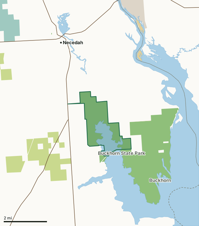
State wildlife areas, forests and other DNR landCounty forestNational wildlife refuges and waterfowl production areasOther federal landState parksOther county, city and regional landYellow River Wildlife AreaCounty lineLakeHighway
| Size | 2,197 acres |
|---|---|
| County | Juneau County |
| Deer Management Unit | DMU Juneau |
| Public access (DNR) | Open to Hiking, Fishing, Hunting and Trapping |
| DNR property page | Yellow River Wildlife Area |
| Nearest towns | Necedah (2 mi), Dellwood (4 mi) and New Lisbon (8 mi) |
What is Yellow River Wildlife Area like?
Yellow River Wildlife Area is a 2,188-acre property contiguous to Buckhorn State Park and Buckhorn Wildlife Area located on Castle Rock Lake in east-central Juneau County off of Highway G. Yellow River Wildlife Area is located to the north and west of the state park boundary, on the north side of Highway G. The property lies within the transition zone of northern conifer-hardwood forests and southern hardwood forests. Prior to logging in 1900, the original vegetation was pine and oak savanna. The Yellow River wildlife area contains a floodplain forest of silver maple, green ash, swamp white oak and river birch. Canopy associates are cottonwood, red oak, box elder, yellowbud hickory, red maple, American elm, basswood and black ash. The low sandy ridges, slightly higher than the surrounding floodplain support white oak, bur oak, shagbark hickory, black cherry and white pine.
Yellow River Wildlife Area is managed to provide quality public hunting, wildlife viewing and other compatible recreational opportunities for a variety of upland, wetland and aquatic habitat types. The area is managed to protect, restore and maintain rare or unique habitats and ecosystems, particularly aquatic habitats, bottomland hardwoods and barrens. The management of this wildlife area is integrated with the adjacent state park and state natural areas to provide high ecological and public use benefits. The Yellow River Oxbows State Natural Area is located within the boundary of the Yellow River Wildlife Area.
In the DNR's words, from its page for the property.
What are the rules on Yellow River Wildlife Area?
The DNR's property map lists Yellow River Wildlife Area as "Open to Hiking, Fishing, Hunting and Trapping". Hunting follows Wisconsin's statewide seasons and the rules posted on the property.
Activities the DNR lists for Yellow River Wildlife Area: Birding, Boating, Canoeing, Cross-country skiing (no designated trail), Fishing, Hiking (no designated trail), Kayaking, Trapping, Wild edibles/gathering and Wildlife viewing.
How many deer are taken around Yellow River Wildlife Area?
Yellow River Wildlife Area lies in DMU Juneau. The DNR registered 4,295 deer in DMU Juneau in 2025.
| DMU | Yellow River Wildlife Area acres in it | Deer, 2025 |
|---|---|---|
| DMU Juneau | 2,197 | 4,295 |
Harvest for the whole deer management unit, not the property alone: Wisconsin DNR Deer Metrics (registered harvest by deer management unit).
How do you get to Yellow River Wildlife Area?
Nearest towns: Necedah (2 miles), Dellwood (4 miles), New Lisbon (8 miles) and Arkdale (8 miles). Highways within 5 miles: WI 80, WI 21 and WI 58.
What other public land is near Yellow River Wildlife Area?
DNR properties within 10 miles:
- Buckhorn State Park: 4,000 acres, next to it
- Buckhorn Wildlife Area: 1,677 acres, 1 mile away
- Central Sands Pines Forest Legacy Easement: 9,122 acres, 5.4 miles away
- Quincy Bluff and Wetlands State Natural Area: 6,591 acres, 6.1 miles away
- Meadow Valley Wildlife Area: 58,144 acres, 6.1 miles away
- Sohlberg Silver Lake State Natural Area: 315 acres, 6.2 miles away
Public land within 3 miles of Yellow River Wildlife Area
Counting Yellow River Wildlife Area itself, 9,386 of the 38,479 acres within 3 miles of its boundary are public land open to the public (24.4%), by USGS PAD-US 4.1 (fee land open to the public).
| Manager | Acres within 3 miles |
|---|---|
| State wildlife areas, forests and other DNR land | 7,857 |
| County forest | 1,468 |
| Other federal land | 58 |
| State parks | 3 |
Questions hunters ask
Where is Yellow River Wildlife Area?
In Juneau County, 2 miles from Necedah. The DNR's property page has its maps and parking.
Is Yellow River Wildlife Area open to hunting?
Yes. The DNR's property map lists it as "Open to Hiking, Fishing, Hunting and Trapping". Posted refuges or closed areas, where there are any, are marked on site.
Which deer management unit is Yellow River Wildlife Area in?
DMU Juneau.
How much public land is around Yellow River Wildlife Area?
9,386 acres within 3 miles of its boundary, Yellow River Wildlife Area included, by PAD-US 4.1. The closest other DNR property is Buckhorn State Park (next to it).
Get a Wisconsin hunt plan when they open
Hunt plans for Wisconsin are coming. Join the list and you'll hear first. The first 50 hunters in each new state get their plan free.
Until then, the free FilledTag app for iPhone has a map that works in every state, Wisconsin included.
Where these facts come from
- Area description, species, rules and directions: DNR, Yellow River Wildlife Area; Wisconsin DNR managed lands open to hunting.
- Boundary and acres: the DNR's map layer above. Surrounding public land: USGS PAD-US 4.1 (fee land open to the public).
- Deer harvest: Wisconsin DNR Deer Metrics (registered harvest by deer management unit).
FilledTag is not part of the Wisconsin Department of Natural Resources. Check the DNR's rules and posted signs before you go.