Knight Ridge West Hunter Management Area: hunting, access and rules
Knight Ridge West Hunter Management Area is 18,901 acres in WGFD's Green River Region. Hunter Management Areas are private and leased lands where WGFD arranges hunting access; hunters need a WGFD permission slip for the area. WGFD lists elk (hunt area 106) for big game hunting here.
Data updated October 2026. Area facts: WGFD's HMA data. Boundary: WGFD GIS. Harvest: WGFD reports to 2025.
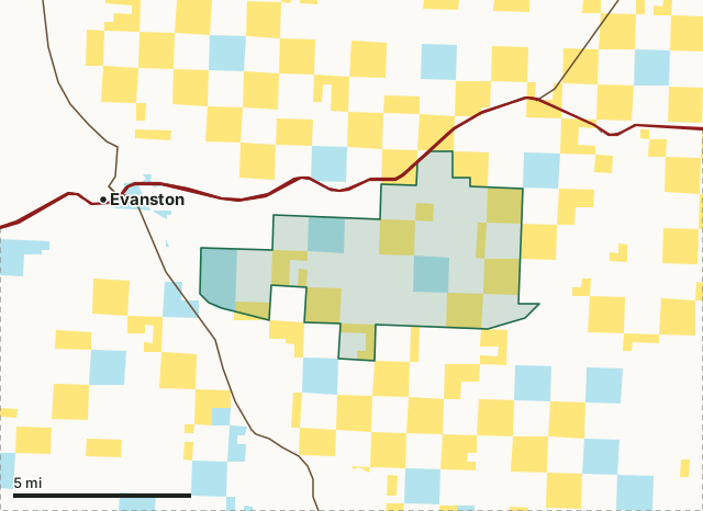
BLMState trust landKnight Ridge West HMAElk hunt area lineLakeHighway
| Size | 18,901 acres (WGFD) |
|---|---|
| WGFD region | Green River Region |
| Big game listed | Elk |
| Nearest towns | Evanston (3 mi), Bear River (12 mi) and Robertson (16 mi) |
What is Knight Ridge West HMA?
The Knight-Ridge-West Hunter Management Area (HMA) is located southeast of Evanston, and is comprised of private and/or leased lands of Dennis Cornelison, Sam Lowham, and Greg Thornock.
What are the rules on Knight Ridge West HMA?
A permission slip from WGFD is needed to hunt an HMA; WGFD issues them on its website, often by drawing or first come, first served, with limits per hunter. WGFD's page for Knight Ridge West has the current slips and rules.
WGFD's permission slip and its page for Knight Ridge West set the rules for this private and leased ground.
What can you hunt on Knight Ridge West HMA?
WGFD lists the hunt area each big game species is hunted under here: elk in area 106.
What did hunters take in the hunt areas around Knight Ridge West HMA?
WGFD reports harvest by hunt area, not by access area. The hunt areas that overlap Knight Ridge West HMA, with the acres of the HMA in each and WGFD's latest harvest for the whole hunt area:
| Hunt area | HMA acres in it | Harvest, whole area | Hunter success |
|---|---|---|---|
| Elk Area 106 | 18,901 | 625 (2025) | 40.8% |
| Deer Area 133 | 18,901 | 174 (2025) | |
| Antelope Area 99 | 18,901 | 144 (2025) | 91.7% |
| Moose Area 27 | 18,901 | 16 (2025) | 100% |
Harvest: WGFD harvest reports, latest year each area was reported (WGFD harvest reports). Acres measured by FilledTag from WGFD's boundaries.
What land is around Knight Ridge West HMA?
Inside the HMA boundary, by manager (WGFD's own holdings and leases are not in the federal and state layers, so they show as unlisted land):
| Manager | Acres inside |
|---|---|
| BLM | 4,550 |
| State trust land | 2,311 |
| Other land (WGFD-held, leased or private) | 12,040 |
Measured by FilledTag from USGS PAD-US 4.1 (federal land) and the Office of State Lands and Investments (state trust land) inside WGFD's boundary (18,901 acres as drawn).
How do you get to Knight Ridge West HMA?
Highways within 8 miles: I-80, US 189, WY 150 and WY 89. Nearest towns: Evanston (3 miles), Bear River (12 miles), Robertson (16 miles) and Fort Bridger (18 miles).
Questions hunters ask
What can you hunt on Knight Ridge West HMA?
WGFD lists elk for big game. Each species follows the season of the hunt area the ground is in.
Where is Knight Ridge West HMA?
About 3 miles from Evanston, and 12 miles from Bear River, measured from the area's boundary.
Do you need permission to hunt Knight Ridge West HMA?
Yes. Hunters need a WGFD permission slip for a Hunter Management Area; WGFD's page for Knight Ridge West lists the slips and the area's rules.
Which hunt areas is Knight Ridge West HMA in?
By WGFD's boundaries it lies in elk Area 106, deer Area 133 and antelope Area 99. Each hunt area's season applies to the ground inside it.
Get notified about FilledTag in Wyoming
Leave your email and we will let you know when FilledTag adds something new for Wyoming hunters.
The free FilledTag app for iPhone has a map that works in every state, Wyoming included.
Where these numbers come from
- Area facts, access dates, rules and species: WGFD Hunter Management Area details; WGFD, Knight Ridge West.
- Boundary: WGFD Hunter Management Area boundaries. Surrounding land: USGS PAD-US 4.1 (federal land) and the Office of State Lands and Investments (state trust land).
- Hunt area harvest: WGFD harvest reports, 2021 to 2025.
FilledTag is not part of the Wyoming Game and Fish Department. Numbers are copied from WGFD and the other agencies named, or measured by FilledTag from their maps; nothing on this page is estimated by FilledTag. WGFD's regulations are the final word on every rule.
Wyoming hunting Green River Region Elk Area 106 Deer Area 133 Antelope Area 99 Moose Area 27