Wyoming hunting data: hunt areas, harvest, seasons and public land
The Wyoming Game and Fish Department sets big game seasons by hunt area: 105 elk, 126 deer, 102 antelope, 38 moose, 19 bighorn sheep and 5 mountain goat areas in 2026. WGFD's 2025 harvest reports estimate hunters took 30,568 elk, 16,688 mule deer, 10,258 white-tailed deer and 22,766 antelope. Inside WGFD's eight wildlife regions, which cover all of Wyoming except Yellowstone National Park, 50.7% of the ground is public land open to hunting under its manager's rules.
Data updated October 2026. Harvest: WGFD reports to 2025. Seasons: WGFD Chapters 5 to 9, final April 2026. Draw: WGFD 2026 demand reports. Land: PAD-US 4.1 and the Office of State Lands.
Each hunt area page puts WGFD's own numbers for one area on one page: its harvest by year from WGFD's harvest reports, every 2026 season row from the Commission's chapters, the 2026 draw demand for its limited quota licenses, and how much of it is public land. Wyoming maps each species' hunt areas on its own, so Elk Area 28 and Deer Area 28 are different places with different lines.
Hunt areas by species
- Elk: 105 hunt areas, 102 with a page of their own
- Deer: 126 hunt areas, 125 with a page of their own
- Antelope: 102 hunt areas, 101 with a page of their own
- Moose: 38 hunt areas, 28 with a page of their own
- Bighorn sheep: 19 hunt areas, 19 with a page of their own
- Mountain goat: 5 hunt areas, 3 with a page of their own
How many big game animals are harvested in Wyoming?
| Year | Elk | Mule deer | White-tailed deer | Antelope | Moose | Bighorn sheep | Mountain goat |
|---|---|---|---|---|---|---|---|
| 2025 | 30,568 | 16,688 | 10,258 | 22,766 | 338 | 242 | 27 |
| 2024 | 30,744 | 15,004 | 11,633 | 22,218 | 317 | 185 | 35 |
| 2023 | 28,353 | 13,572 | 10,844 | 21,228 | 331 | 182 | 39 |
| 2022 | 27,011 | 17,785 | 11,530 | 28,254 | 334 | 162 | 43 |
| 2021 | 24,333 | 18,944 | 16,117 | 31,965 | 329 | 148 | 40 |
Source: the statewide tables in WGFD's annual harvest reports, 2021 to 2025. Each hunt area page shows its own rows from the same reports.
When are Wyoming's 2026 big game seasons?
The Commission sets every season by hunt area and license type in its chapters for each species. The table counts what the 2026 chapters print. Each hunt area page lists its own rows, with WGFD's limitations in WGFD's words.
| Species | Areas open in 2026 | Areas with a general license | Most common archery opening | Most common regular opening | Earliest regular opening | Latest regular closing |
|---|---|---|---|---|---|---|
| Elk | 103 of 105 | 52 | September 1 (208 rows) | October 1 (98 rows) | August 1 | January 31 |
| Deer | 125 of 126 | 100 | September 1 (312 rows) | October 1 (133 rows) | August 15 | January 31 |
| Antelope | 101 of 102 | 0 | August 15 (186 rows) | October 1 (50 rows) | August 15 | December 31 |
| Moose | 30 of 38 | none | September 1 (39 rows) | October 1 (27 rows) | September 10 | November 30 |
| Bighorn sheep | 19 of 19 | none | August 15 (21 rows) | September 1 (19 rows) | August 1 | November 30 |
| Mountain goat | 3 of 5 | none | August 15 (4 rows) | September 1 (4 rows) | September 1 | October 31 |
Counted by FilledTag from every row of WGFD Commission Chapters 5 (antelope), 6 (deer), 7 (elk), 8 (moose) and 9 (bighorn sheep and mountain goat), final April 2026: Chapter 5, Chapter 6, Chapter 7, Chapter 8, Chapter 9. A season that runs past December closes in 2027.
When are Wyoming's draw deadlines?
| Application | Opened | Closed | Results |
|---|---|---|---|
| Nonresident elk application (initial drawing) | January 2, 2026 | February 2, 2026 | May 21, 2026 |
| Moose application, residents and nonresidents (initial drawing) | January 2, 2026 | April 30, 2026 | May 21, 2026 |
| Deer and antelope application, residents and nonresidents, and resident elk (initial drawing) | January 2, 2026 | June 1, 2026 | June 18, 2026 |
| Preference point only application (no license) | July 1, 2026 | November 2, 2026 |
Source: WGFD Application Dates & Deadlines, 2026 cycle. WGFD has not yet posted 2027 application dates. Its rules (Chapter 44) open the big game application period in January each year, with nonresident elk closing at the end of January and deer, antelope and resident elk at the end of May; moose closes at the end of April. WGFD moves a closing date to the next business day when it falls on a weekend, which is why 2026 closed on February 2 and June 1. From January 1, 2027 the nonresident antelope, deer and elk preference point fee goes up to $75 each. Fees, points and every deadline are on the Wyoming draw page.
How do Wyoming's licenses and preference points work?
Preference points give a drawing advantage for nonresident antelope, deer and elk licenses and for full price moose licenses (residents and nonresidents). Residents draw antelope, deer and elk by random drawing with no points.
After landowner licenses, nonresident antelope, deer and elk licenses go 40% to the special (higher fee) drawing and 60% to the regular drawing. Within each, not less than 75% go to a preference point drawing and up to 25% to a random drawing. Applicants who miss in the preference point drawing go on to the random drawing for the remaining licenses, with no advantage for points.
Applicants are grouped by their points for that species. The highest point group draws first, then the next, until the quota is filled; where a group is larger than the licenses left, a random drawing picks among them. Points count only for the first choice. Party applications with different points are averaged to four decimal places.
Source: WGFD Commission Chapter 44.
How much of Wyoming is public land?
WGFD's eight regions cover 60,543,787 acres, all of Wyoming except Yellowstone National Park. 50.7% of that is public land open to hunting under its manager's rules: BLM 28.9%, national forest 15.2%, state trust land 5.9% and Bureau of Reclamation 0.7%.
| Manager | Acres | Share of the eight regions |
|---|---|---|
| BLM | 17,477,738 | 28.9% |
| National forest | 9,215,672 | 15.2% |
| State trust land | 3,577,129 | 5.9% |
| Wind River Reservation (as PAD-US maps it) | 2,258,138 | 3.7% |
| Bureau of Reclamation | 409,028 | 0.7% |
| National park (no general hunting) | 327,305 | 0.5% |
| Other public (state parks, military) | 159,073 | 0.3% |
| National wildlife refuge | 65,473 | 0.1% |
The Office of State Lands and Investments classes every parcel of state trust land by access. Of the 3,619,762 acres in its parcel layer (a little more than the table, where parcels that overlap federal land are counted once), 1,527,259 have road access or access from other state land, 1,045,178 sit next to other public land, and 1,036,973 have no known public access.
State trust land is open to hunting where it can be reached legally, but overnight camping and open fires are not allowed on it. Public land surrounded by private land can be reached legally only where a public road or other public land touches it, so the access classes above matter.
A nonresident hunting big game in a designated wilderness area in Wyoming must be accompanied by a licensed professional guide or a resident guide (W.S. 23-2-401). Each hunt area page lists the wilderness inside it.
Tribal land on the Wind River Reservation, home of the Eastern Shoshone and Northern Arapaho tribes, is not open to hunting on Wyoming licenses; the land table above counts the whole reservation as PAD-US maps it, which takes in some private and WGFD-managed ground. Yellowstone and Grand Teton national parks are closed to general hunting.
Measured by FilledTag from USGS PAD-US 4.1 (federal land) and the Office of State Lands and Investments (state trust land).
What are WHMAs, PAAs, HMAs and Walk-In Areas?
WGFD's maps hold 48 Wildlife Habitat Management Areas (430,905 acres as drawn), 165 Public Access Areas (266,114 acres), 74 Hunter Management Areas (1,375,384 acres) and 859 Walk-In Hunting Areas (804,772 acres).
Wildlife Habitat Management Areas are lands WGFD owns or manages for wildlife habitat and public hunting and fishing. Many close to people for part of the year to protect wintering animals, and each has its own dates and rules.
Public Access Areas are places where WGFD has bought or leased public access, most often to a river or lake and the ground around it. Some allow big game hunting; WGFD lists the species for each.
Hunter Management Areas are private and leased lands where WGFD arranges hunting access. A hunter needs a WGFD permission slip for the area. Walk-In Hunting Areas are private lands enrolled in WGFD's Access Yes program, open to hunters on foot during the dates WGFD lists for each.
Pages so far: 39 WHMAs, 11 PAAs, 59 HMAs, each linked from its region's page.
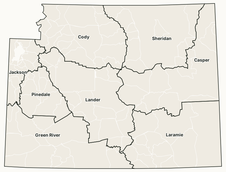
Wyoming's wildlife regions
| Region | Square miles | Public land | Elk areas | Deer areas | Antelope areas | Elk taken, 2025 |
|---|---|---|---|---|---|---|
| Casper | 14,872 | 32% | 9 | 19 | 18 | 2,900 |
| Cody | 12,685 | 72.4% | 18 | 33 | 11 | 3,993 |
| Green River | 15,142 | 68.4% | 12 | 10 | 14 | 4,808 |
| Jackson | 4,086 | 78.7% | 18 | 9 | 1 | 2,629 |
| Lander | 13,882 | 58.8% | 16 | 13 | 19 | 3,543 |
| Laramie | 15,468 | 27.8% | 13 | 14 | 16 | 6,976 |
| Pinedale | 5,135 | 80.6% | 10 | 9 | 6 | 2,575 |
| Sheridan | 13,329 | 28.7% | 9 | 19 | 17 | 3,144 |
Each hunt area is counted in the region that holds most of it. Harvest: WGFD's 2025 elk report. Land: USGS PAD-US 4.1 (federal land) and the Office of State Lands and Investments (state trust land).
Questions hunters ask
How many hunt areas does Wyoming have?
In 2026 WGFD maps 105 elk hunt areas, 126 deer hunt areas, 102 antelope hunt areas, 38 moose, 19 bighorn sheep and 5 mountain goat hunt areas. Each species has its own map, so the same number means a different place for each.
When is the Wyoming elk application deadline?
In the 2026 cycle the nonresident elk application closed February 2, 2026, and resident elk, deer and antelope applications closed June 1, 2026 (WGFD Application Dates and Deadlines). WGFD has not posted 2027 dates yet.
Do residents need preference points in Wyoming?
Not for antelope, deer or elk. Residents draw those by random drawing with no points; points give an advantage for nonresident antelope, deer and elk licenses and for full price moose licenses for residents and nonresidents (WGFD Commission Chapter 44).
Can you hunt state land in Wyoming?
Yes, where it can be reached legally. State trust land is open to hunting, but overnight camping and open fires are not allowed on it. The Office of State Lands and Investments classes 1,036,973 acres of state trust land as having no known public access.
Can a nonresident hunt a wilderness area in Wyoming?
Only with a guide. Wyoming law requires a nonresident hunting big game in a designated wilderness area to be accompanied by a licensed professional guide or a resident guide (W.S. 23-2-401).
Get notified about FilledTag in Wyoming
Leave your email and we will let you know when FilledTag adds something new for Wyoming hunters.
The free FilledTag app for iPhone has a map that works in every state, Wyoming included.
Where these numbers come from
- Hunt areas, regions and access areas: WGFD's public map services.
- Harvest: WGFD harvest reports, 2021 to 2025.
- Seasons: WGFD Commission Chapters 5 to 9, final April 2026. Draw: WGFD 2026 demand reports.
- Public land: USGS PAD-US 4.1 (federal land) and the Office of State Lands and Investments (state trust land).
FilledTag is not part of the Wyoming Game and Fish Department. Numbers are copied from WGFD and the other agencies named, or measured by FilledTag from their maps; nothing on this page is estimated by FilledTag. WGFD's regulations are the final word on every rule.