Lander Region: Wyoming hunt areas, harvest and public land
WGFD's Lander Region covers 13,882 square miles and is 58.8% public land. 16 elk, 13 deer and 19 antelope hunt areas lie mostly inside it, and those elk areas took 3,543 elk in 2025 by WGFD's harvest report.
Data updated October 2026. Harvest: WGFD reports to 2025. Land: PAD-US 4.1 and the Office of State Lands. Boundaries: WGFD.
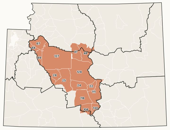
The Lander Region covers the east slope of the Wind River Range, the Wind River Basin around Riverton and Lander, and south to Rawlins. Its office is in Lander. The Wind River Reservation lies inside it; tribal land there is not open to hunting on Wyoming licenses.
Which hunt areas are in the Lander Region?
Each hunt area is listed under the region that holds most of it. Some areas cross a region line.
Elk: 16 hunt areas
The elk hunt areas mostly inside the Lander Region took 3,543 elk in 2025, by WGFD's report.
| Area | Name | Square miles | Public land | Harvest, latest |
|---|---|---|---|---|
| Area 22 | Ferris | 325 | 87.6% | 123 (2025) |
| Area 24 | Green Mountain | 679 | 90.7% | 216 (2025) |
| Area 25 | South Pass | 1,213 | 83.6% | 250 (2025) |
| Area 27 | Upper Sweetwater | 118 | 93.8% | 47 (2025) |
| Area 28 | Cony Mountain | 542 | 82% | 398 (2025) |
| Area 47 | Copper Mountain | 697 | 62.9% | 46 (2025) |
| Area 48 | Upper Nowood | 930 | 58.1% | 420 (2025) |
| Area 67 | Wigins Fork | 700 | 80.4% | 953 (2025) |
| Area 68 | Warm Springs | 214 | 85.8% | 206 (2025) |
| Area 69 | Whiskey Mountain | 332 | 93.4% | 115 (2025) |
| Area 108 | South Rawlins | 574 | 50.7% | 325 (2025) |
| Area 111 | Seminoe | 919 | 57.7% | 165 (2025) |
| Area 118 | Shamrock Hills | 1,093 | 66.4% | 112 (2025) |
| Area 127 | Crowheart Butte | 3,080 | 0% | 54 (2025) |
| Area 128 | Muskrat | 2,198 | 80.4% | 109 (2025) |
| Area 130 | Bolten Rim | 268 | 46.8% | 4 (2025) |
Deer: 13 hunt areas
The deer hunt areas mostly inside the Lander Region took 1,666 deer in 2025, by WGFD's report (mule deer and white-tailed deer added together).
| Area | Name | Square miles | Public land | Harvest, latest |
|---|---|---|---|---|
| Area 36 | Badwater | 899 | 68% | 89 (2025) |
| Area 84 | Atlantic Rim | 574 | 50.7% | 13 (2025) |
| Area 87 | Ferris | 1,220 | 65.4% | 43 (2025) |
| Area 90 | Muskrat | 1,291 | 78.4% | 25 (2025) |
| Area 92 | Table Mountain | 660 | 84.1% | 205 (2025) |
| Area 94 | Twin Creek | 641 | 83.2% | 57 (2025) |
| Area 96 | Green Mountain | 679 | 90.7% | 158 (2025) |
| Area 97 | Sweetwater Rocks | 907 | 83.4% | 50 (2025) |
| Area 98 | Chain Lakes | 1,093 | 66.4% | 23 (2025) |
| Area 128 | Wind River | 1,246 | 84.8% | 390 (2025) |
| Area 157 | Boysen | 664 | 0% | 380 (2025) |
| Area 160 | Beaver Creek | 404 | 77.6% | 24 (2025) |
| Area 171 | Crowheart Butte | 2,384 | 0% | 209 (2025) |
Antelope: 19 hunt areas
The antelope hunt areas mostly inside the Lander Region took 1,713 antelope in 2025, by WGFD's report.
| Area | Name | Square miles | Public land | Harvest, latest |
|---|---|---|---|---|
| Area 55 | Red Rim | 382 | 47.8% | 31 (2025) |
| Area 56 | Iron Springs | 268 | 46.8% | 10 (2025) |
| Area 60 | Table Rock | 1,609 | 74.3% | 52 (2025) |
| Area 61 | Chain Lakes | 1,254 | 70% | 96 (2025) |
| Area 62 | South Ferris | 728 | 59.2% | 19 (2025) |
| Area 63 | North Ferris | 516 | 74.5% | 71 (2025) |
| Area 64 | Bison Basin | 521 | 96.4% | 81 (2025) |
| Area 65 | South Pass | 865 | 79.5% | 100 (2025) |
| Area 66 | Lander | 403 | 77.7% | 96 (2025) |
| Area 67 | Sand Draw | 800 | 89.8% | 172 (2025) |
| Area 68 | Split Rock | 807 | 81.3% | 186 (2025) |
| Area 74 | Deer Creek | 464 | 57.4% | 138 (2025) |
| Area 75 | Badwater | 917 | 67.2% | 203 (2025) |
| Area 84 | Wind River | 1,246 | 84.8% | 123 (2025) |
| Area 97 | Boysen | 416 | 0% | 124 (2025) |
| Area 106 | Long Creek | 482 | 89.7% | 102 (2025) |
| Area 107 | Upper Sweetwater | 306 | 90% | 82 (2025) |
| Area 108 | Bridger Pass | 192 | 56.5% | 24 (2025) |
| Area 117 | Crowheart Butte | 2,626 | 0% | 3 (2025) |
Moose: 2 hunt areas
The moose hunt areas mostly inside the Lander Region took 9 moose in 2025, by WGFD's report.
| Area | Name | Square miles | Public land | Harvest, latest |
|---|---|---|---|---|
| Area 2 | Lander Area | 1,810 | 83.1% | 4 (2025) |
| Area 6 | Wind River | 1,246 | 84.8% | 5 (2025) |
Bighorn sheep: 4 hunt areas
The bighorn sheep hunt areas mostly inside the Lander Region took 61 bighorn sheep in 2025, by WGFD's report.
| Area | Name | Square miles | Public land | Harvest, latest |
|---|---|---|---|---|
| Area 9 | Dinwoody | 252 | 94.5% | 1 (2025) |
| Area 10 | Jakey's Fork | 395 | 90.1% | 5 (2025) |
| Area 17 | Ferris-Seminoe | 1,244 | 65.5% | 52 (2025) |
| Area 22 | Dubois Badlands | 135 | 34.5% | 3 (2025) |
Harvest: WGFD harvest reports. Public land measured by FilledTag from USGS PAD-US 4.1 (federal land) and the Office of State Lands and Investments (state trust land).
How much public land is in the Lander Region?
| Manager | Acres | Share of the region |
|---|---|---|
| BLM | 3,912,624 | 44% |
| Wind River Reservation (as PAD-US maps it) | 1,987,960 | 22.4% |
| National forest | 891,767 | 10% |
| State trust land | 408,137 | 4.6% |
| Bureau of Reclamation | 14,731 | 0.2% |
| Other public (state parks, military) | 13,217 | 0.1% |
| National wildlife refuge | 2,856 | under 0.1% |
In the Office of State Lands and Investments' own parcel layer, the region holds 415,047 acres of state trust land; it classes 42,445 acres as having no known public access and 126,440 acres with road access or access from other state land.
WGFD access areas in the Lander Region
WGFD's data places 10 Wildlife Habitat Management Areas, 13 Public Access Areas, 2 Hunter Management Areas and 189 Walk-In Hunting Areas mostly in this region. Those with a page of their own:
- Chain Lakes WHMA: 62,387 acres
- Spence and Moriarity WHMA: 35,872 acres
- Red Rim-Daley WHMA: 25,915 acres
- Sand Mesa WHMA: 19,357 acres
- Kirk Inberg/Kevin Roy WHMA: 17,280 acres
- Stone Creek HMA: 14,844 acres
- Whiskey Basin WHMA: 12,833 acres
- Ocean Lake WHMA: 11,289 acres
- Badwater Ranch PAA: 10,211 acres
- Morgan Creek WHMA: 4,738 acres
- Mexican Creek PAA: 2,326 acres
- Red Canyon WHMA: 1,987 acres
- Mud Springs PAA: 1,837 acres
Questions hunters ask
How much public land is in WGFD's Lander Region?
58.8% of the region's 8,884,737 acres is public land open to hunting under its manager's rules, measured by FilledTag from USGS PAD-US 4.1 and Office of State Lands data.
How many elk hunt areas are in the Lander Region?
16 elk hunt areas lie mostly inside it, along with 13 deer and 19 antelope hunt areas, by WGFD's boundaries.
What WGFD access areas are in the Lander Region?
Among others: Chain Lakes WHMA (62,387 acres), Kirk Inberg/Kevin Roy WHMA (17,280 acres), Morgan Creek WHMA (4,738 acres), Ocean Lake WHMA (11,289 acres) and Red Canyon WHMA (1,987 acres). Each has its own page with WGFD's access dates and rules.
Get notified about FilledTag in Wyoming
Leave your email and we will let you know when FilledTag adds something new for Wyoming hunters.
The free FilledTag app for iPhone has a map that works in every state, Wyoming included.
Where these numbers come from
- Region boundaries: WGFD wildlife administrative regions.
- Harvest: WGFD harvest reports.
- Public land: USGS PAD-US 4.1 (federal land) and the Office of State Lands and Investments (state trust land).
FilledTag is not part of the Wyoming Game and Fish Department. Numbers are copied from WGFD and the other agencies named, or measured by FilledTag from their maps; nothing on this page is estimated by FilledTag. WGFD's regulations are the final word on every rule.
Wyoming hunting Casper Region Cody Region Green River Region Jackson Region Laramie Region Pinedale Region Sheridan Region