Laramie Region: Wyoming hunt areas, harvest and public land
WGFD's Laramie Region covers 15,468 square miles and is 27.8% public land. 13 elk, 14 deer and 16 antelope hunt areas lie mostly inside it, and those elk areas took 6,976 elk in 2025 by WGFD's harvest report.
Data updated October 2026. Harvest: WGFD reports to 2025. Land: PAD-US 4.1 and the Office of State Lands. Boundaries: WGFD.
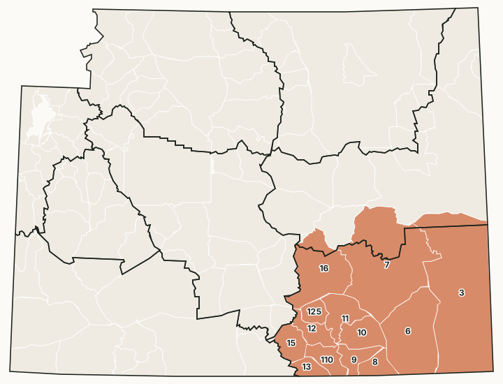
The Laramie Region covers southeast Wyoming around Cheyenne, Laramie, Wheatland, Torrington and Saratoga, including the Medicine Bow Mountains and the Sierra Madre. Its office is in Laramie. It has the most Hunter Management Areas and Wildlife Habitat Management Areas of any region.
Which hunt areas are in the Laramie Region?
Each hunt area is listed under the region that holds most of it. Some areas cross a region line.
Elk: 13 hunt areas
The elk hunt areas mostly inside the Laramie Region took 6,976 elk in 2025, by WGFD's report.
| Area | Name | Square miles | Public land | Harvest, latest |
|---|---|---|---|---|
| Area 3 | Rawhide | 5,295 | 8.8% | 253 (2025) |
| Area 6 | Iron Mountain | 2,175 | 15.7% | 614 (2025) |
| Area 7 | Laramie Peak | 4,042 | 28.5% | 2,386 (2025) |
| Area 8 | Boulder Ridge | 377 | 18.2% | 189 (2025) |
| Area 9 | South Snowy Range | 409 | 61.9% | 266 (2025) |
| Area 10 | Rock Creek | 662 | 29.1% | 306 (2025) |
| Area 11 | Medicine Bow River | 692 | 33.8% | 393 (2025) |
| Area 12 | Kennaday Peak | 446 | 56.5% | 561 (2025) |
| Area 13 | Encampment River | 303 | 73.8% | 315 (2025) |
| Area 15 | Spring Creek | 503 | 61.5% | 317 (2025) |
| Area 16 | Shirley Mountain | 1,756 | 52.4% | 562 (2025) |
| Area 110 | Upper Platte River | 457 | 72.7% | 596 (2025) |
| Area 125 | Elk Mountain | 288 | 33.3% | 218 (2025) |
Deer: 14 hunt areas
The deer hunt areas mostly inside the Laramie Region took 3,665 deer in 2025, by WGFD's report (mule deer and white-tailed deer added together).
| Area | Name | Square miles | Public land | Harvest, latest |
|---|---|---|---|---|
| Area 15 | Southeast Wyoming | 5,295 | 8.8% | 1,107 (2025) |
| Area 59 | South Laramie Mountains | 1,350 | 13.2% | 412 (2025) |
| Area 60 | Pole Mountain | 487 | 25% | 248 (2025) |
| Area 61 | Harriman | 339 | 12% | 51 (2025) |
| Area 64 | Laramie Peak | 2,963 | 30.4% | 538 (2025) |
| Area 70 | Shirley Mountain | 1,149 | 54.7% | 227 (2025) |
| Area 74 | Kyle | 843 | 22.5% | 75 (2025) |
| Area 75 | Four Mile | 511 | 46.3% | 164 (2025) |
| Area 76 | Sheep Mountain | 409 | 61.9% | 257 (2025) |
| Area 77 | Boulder Ridge | 377 | 18.2% | 31 (2025) |
| Area 78 | French Creek | 457 | 72.7% | 214 (2025) |
| Area 79 | Kennaday Peak | 914 | 46.7% | 131 (2025) |
| Area 80 | Spring Creek | 771 | 56.4% | 93 (2025) |
| Area 81 | Blackhall | 304 | 73.8% | 117 (2025) |
Antelope: 16 hunt areas
The antelope hunt areas mostly inside the Laramie Region took 5,454 antelope in 2025, by WGFD's report.
| Area | Name | Square miles | Public land | Harvest, latest |
|---|---|---|---|---|
| Area 11 | Rawhide Butte | 1,825 | 9.6% | 305 (2025) |
| Area 34 | Goshen Hole | 2,867 | 8.4% | 391 (2025) |
| Area 37 | Harriman | 339 | 12% | 337 (2025) |
| Area 38 | Iron Mountain | 2,357 | 17.9% | 497 (2025) |
| Area 42 | Laramie Plains | 1,111 | 34% | 287 (2025) |
| Area 43 | Cooper Lake | 445 | 19.3% | 195 (2025) |
| Area 44 | South Laramie | 427 | 26.3% | 130 (2025) |
| Area 45 | West Laramie | 654 | 46.6% | 635 (2025) |
| Area 46 | Kyle | 398 | 26.2% | 189 (2025) |
| Area 47 | Shirley Basin | 1,103 | 48.4% | 1,289 (2025) |
| Area 48 | Leo-Hanna | 856 | 50.6% | 316 (2025) |
| Area 50 | Elk Mountain | 1,186 | 61.7% | 349 (2025) |
| Area 51 | Big Creek | 318 | 58.9% | 89 (2025) |
| Area 52 | Spring Creek | 616 | 64% | 122 (2025) |
| Area 103 | Dwyer | 1,128 | 17.8% | 183 (2025) |
| Area 111 | Chalk Bluffs | 440 | 6.6% | 140 (2025) |
Moose: 2 hunt areas
The moose hunt areas mostly inside the Laramie Region took 60 moose in 2025, by WGFD's report.
| Area | Name | Square miles | Public land | Harvest, latest |
|---|---|---|---|---|
| Area 38 | Snowy Range | 3,235 | 42.8% | 53 (2025) |
| Area 45 | Pole Mountain | 2,176 | 15.7% | 7 (2025) |
Bighorn sheep: 4 hunt areas
The bighorn sheep hunt areas mostly inside the Laramie Region took 20 bighorn sheep in 2025, by WGFD's report.
| Area | Name | Square miles | Public land | Harvest, latest |
|---|---|---|---|---|
| Area 18 | Douglas Creek | 2,300 | 50.1% | 3 (2025) |
| Area 19 | Laramie Peak | 5,494 | 29.4% | 10 (2025) |
| Area 21 | Encampment River | 1,073 | 71.3% | 2 (2025) |
| Area 26 | Bennett Mountain | 252 | 54.1% | 5 (2025) |
Harvest: WGFD harvest reports. Public land measured by FilledTag from USGS PAD-US 4.1 (federal land) and the Office of State Lands and Investments (state trust land).
How much public land is in the Laramie Region?
| Manager | Acres | Share of the region |
|---|---|---|
| BLM | 1,193,428 | 12.1% |
| National forest | 815,503 | 8.2% |
| State trust land | 729,523 | 7.4% |
| Other public (state parks, military) | 128,364 | 1.3% |
| Bureau of Reclamation | 11,113 | 0.1% |
| National wildlife refuge | 5,920 | 0.1% |
| National park (no general hunting) | 895 | under 0.1% |
In the Office of State Lands and Investments' own parcel layer, the region holds 758,594 acres of state trust land; it classes 354,613 acres as having no known public access and 301,642 acres with road access or access from other state land.
WGFD access areas in the Laramie Region
WGFD's data places 14 Wildlife Habitat Management Areas, 34 Public Access Areas, 35 Hunter Management Areas and 206 Walk-In Hunting Areas mostly in this region. Those with a page of their own:
- Hanna Draw HMA: 88,389 acres
- Broom Creek HMA: 71,723 acres
- Como Bluffs HMA: 62,008 acres
- Diamond Lake HMA: 43,383 acres
- Laramie River HMA: 39,706 acres
- Simpson Ridge HMA: 37,765 acres
- Laramie Peak WHMA: 37,114 acres
- East Division HMA: 36,730 acres
- Shirley Basin HMA: 36,673 acres
- Wick Brothers/Beumee WHMA: 23,408 acres
- Medicine Bow River HMA: 23,094 acres
- Nimmo HMA: 22,265 acres
- X-Bar Ranch HMA: 18,748 acres
- Hart Monolith Ranch HMA: 17,813 acres
- McFarlane HMA: 16,645 acres
- Lone Tree Creek HMA: 15,312 acres
- Strouss Hill HMA: 15,228 acres
- Beer Mug HMA: 11,781 acres
- Lewis Ranch HMA: 11,570 acres
- Pine Draw HMA: 11,348 acres
- Pathfinder HMA: 10,597 acres
- Mule Creek Ranch WHMA: 10,107 acres
- Pennock Mountain WHMA: 9,858 acres
- Bell Otte HMA: 9,798 acres
- Pinto Creek HMA: 9,312 acres
- Menter Knob HMA: 7,040 acres
- Harrison Creek HMA: 6,969 acres
- Missouri John HMA: 6,929 acres
- Spiegelberg HMA: 5,975 acres
- North Crow HMA: 5,857 acres
- Morton Pass HMA: 5,666 acres
- Elk Mountain HMA: 5,476 acres
- Mule Creek HMA: 4,007 acres
- Marshall HMA: 3,666 acres
- Springer/Bump Sullivan WHMA: 3,416 acres
- Cherokee Park HMA: 3,294 acres
- Pilot Hill WHMA: 3,012 acres
- Pilot Hill HMA: 3,012 acres
- Tom Thorne/Beth Williams WHMA: 2,961 acres
- North Platte River Glendo - Muddy Bay PAA: 2,757 acres
- North Glendo WHMA: 2,663 acres
- Chalk Hill HMA: 2,407 acres
- Table Mountain WHMA: 1,720 acres
- Forbes/Sheep Mountain WHMA: 1,579 acres
- FE Warren HMA: 1,524 acres
- North Platte River Glendo - Airport Bay PAA: 1,460 acres
- Jelm WHMA: 1,098 acres
- Rawhide WHMA: 817 acres
- Cottonwood Draw WHMA: 700 acres
- John/Annie Woodhouse WHMA: 679 acres
Questions hunters ask
How much public land is in WGFD's Laramie Region?
27.8% of the region's 9,899,305 acres is public land open to hunting under its manager's rules, measured by FilledTag from USGS PAD-US 4.1 and Office of State Lands data.
How many elk hunt areas are in the Laramie Region?
13 elk hunt areas lie mostly inside it, along with 14 deer and 16 antelope hunt areas, by WGFD's boundaries.
What WGFD access areas are in the Laramie Region?
Among others: Cottonwood Draw WHMA (700 acres), Forbes/Sheep Mountain WHMA (1,579 acres), Jelm WHMA (1,098 acres), John/Annie Woodhouse WHMA (679 acres) and Laramie Peak WHMA (37,114 acres). Each has its own page with WGFD's access dates and rules.
Get notified about FilledTag in Wyoming
Leave your email and we will let you know when FilledTag adds something new for Wyoming hunters.
The free FilledTag app for iPhone has a map that works in every state, Wyoming included.
Where these numbers come from
- Region boundaries: WGFD wildlife administrative regions.
- Harvest: WGFD harvest reports.
- Public land: USGS PAD-US 4.1 (federal land) and the Office of State Lands and Investments (state trust land).
FilledTag is not part of the Wyoming Game and Fish Department. Numbers are copied from WGFD and the other agencies named, or measured by FilledTag from their maps; nothing on this page is estimated by FilledTag. WGFD's regulations are the final word on every rule.
Wyoming hunting Casper Region Cody Region Green River Region Jackson Region Lander Region Pinedale Region Sheridan Region