Green River Region: Wyoming hunt areas, harvest and public land
WGFD's Green River Region covers 15,142 square miles and is 68.4% public land. 12 elk, 10 deer and 14 antelope hunt areas lie mostly inside it, and those elk areas took 4,808 elk in 2025 by WGFD's harvest report.
Data updated October 2026. Harvest: WGFD reports to 2025. Land: PAD-US 4.1 and the Office of State Lands. Boundaries: WGFD.
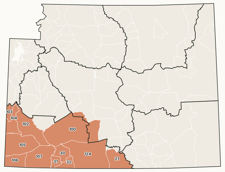
The Green River Region covers southwest Wyoming around Rock Springs, Green River, Kemmerer and Evanston, out to the Utah and Idaho lines. Its office is in Green River. BLM land makes up most of its public ground.
Which hunt areas are in the Green River Region?
Each hunt area is listed under the region that holds most of it. Some areas cross a region line.
Elk: 12 hunt areas
The elk hunt areas mostly inside the Green River Region took 4,808 elk in 2025, by WGFD's report.
| Area | Name | Square miles | Public land | Harvest, latest |
|---|---|---|---|---|
| Area 21 | Baggs | 1,002 | 73.2% | 1,400 (2025) |
| Area 30 | Aspen Mountain | 552 | 57.4% | 102 (2025) |
| Area 31 | Little Mountain | 280 | 89.5% | 85 (2025) |
| Area 32 | Pine Mountain | 378 | 96.2% | 116 (2025) |
| Area 100 | Steamboat | 3,735 | 72.6% | 425 (2025) |
| Area 102 | West Green River | 1,490 | 73.6% | 559 (2025) |
| Area 103 | Raymond Mountain | 265 | 76.5% | 308 (2025) |
| Area 104 | Lincoln | 676 | 71.2% | 588 (2025) |
| Area 105 | Carter Lease | 1,698 | 51.6% | 214 (2025) |
| Area 106 | Unita | 732 | 24.4% | 625 (2025) |
| Area 107 | Hickey Mountain | 1,525 | 69.7% | 166 (2025) |
| Area 124 | Powder Rim | 2,869 | 70.2% | 220 (2025) |
Deer: 10 hunt areas
The deer hunt areas mostly inside the Green River Region took 1,981 deer in 2025, by WGFD's report (mule deer and white-tailed deer added together).
| Area | Name | Square miles | Public land | Harvest, latest |
|---|---|---|---|---|
| Area 82 | Baggs | 1,002 | 73.2% | 548 (2025) |
| Area 100 | South Wamsutter | 1,775 | 73% | 61 (2025) |
| Area 101 | Black Butte | 1,093 | 65.8% | 25 (2025) |
| Area 102 | Aspen Mountain | 1,211 | 77% | 132 (2025) |
| Area 131 | Steamboat | 4,232 | 75.2% | 108 (2025) |
| Area 132 | Cedar Mountain | 1,686 | 67.1% | 297 (2025) |
| Area 133 | Uinta | 571 | 19.3% | 174 (2025) |
| Area 134 | Bear River Divide | 1,249 | 54.2% | 143 (2025) |
| Area 135 | West Green River | 2,400 | 73.3% | 298 (2025) |
| Area 168 | Medicine Butte | 448 | 44.1% | 195 (2025) |
Antelope: 14 hunt areas
The antelope hunt areas mostly inside the Green River Region took 1,907 antelope in 2025, by WGFD's report.
| Area | Name | Square miles | Public land | Harvest, latest |
|---|---|---|---|---|
| Area 53 | Baggs | 1,002 | 73.2% | 49 (2025) |
| Area 57 | South Wamsutter | 1,775 | 73% | 109 (2025) |
| Area 58 | Black Butte-Kenny Rim | 1,093 | 65.8% | 44 (2025) |
| Area 59 | Aspen Mountain | 552 | 57.4% | 134 (2025) |
| Area 92 | Steamboat | 1,343 | 76.6% | 163 (2025) |
| Area 93 | West Green River | 924 | 83.7% | 282 (2025) |
| Area 94 | Carter Lease | 856 | 47.4% | 400 (2025) |
| Area 95 | Cedar Mountain | 1,339 | 70% | 313 (2025) |
| Area 96 | West Farson | 1,286 | 58.9% | 69 (2025) |
| Area 98 | Sage | 942 | 72.8% | 38 (2025) |
| Area 99 | Uinta | 918 | 33.1% | 144 (2025) |
| Area 100 | Bear River Divide | 842 | 55.8% | 89 (2025) |
| Area 101 | Yellow Point | 1,360 | 96% | 29 (2025) |
| Area 112 | Pine Mountain | 658 | 93.3% | 44 (2025) |
Moose: 8 hunt areas
The moose hunt areas mostly inside the Green River Region took 84 moose in 2025, by WGFD's report.
| Area | Name | Square miles | Public land | Harvest, latest |
|---|---|---|---|---|
| Area 26 | Lincoln | 1,799 | 78.7% | 42 (2025) |
| Area 27 | Uinta | 732 | 24.4% | 16 (2025) |
| Area 33 | Lower Green River | 277 | 56.3% | 5 (2025) |
| Area 35 | Henry's Fork | 1,525 | 69.7% | 5 (2025) |
| Area 36 | Bear River Divide | 842 | 55.8% | 5 (2025) |
| Area 40 | Lower Hams Fork | 1,524 | 53% | 6 (2025) |
| Area 41 | Sierra Madres | 2,745 | 62.9% | 5 (2025) |
| Area 44 | East Flaming Gorge | 2,304 | 71.7% | 0 (2025) |
Harvest: WGFD harvest reports. Public land measured by FilledTag from USGS PAD-US 4.1 (federal land) and the Office of State Lands and Investments (state trust land).
How much public land is in the Green River Region?
| Manager | Acres | Share of the region |
|---|---|---|
| BLM | 5,495,758 | 56.7% |
| National forest | 561,388 | 5.8% |
| State trust land | 376,609 | 3.9% |
| Bureau of Reclamation | 194,435 | 2% |
| National wildlife refuge | 31,966 | 0.3% |
| National park (no general hunting) | 8,311 | 0.1% |
In the Office of State Lands and Investments' own parcel layer, the region holds 378,786 acres of state trust land; it classes 85,424 acres as having no known public access and 105,130 acres with road access or access from other state land.
WGFD access areas in the Green River Region
WGFD's data places 1 Wildlife Habitat Management Area, 11 Public Access Areas, 4 Hunter Management Areas and 54 Walk-In Hunting Areas mostly in this region. Those with a page of their own:
- Bear River Divide PAA: 230,346 acres
- Bear River Divide HMA: 217,963 acres
- Red Rim-Grizzly WHMA: 38,354 acres
- Tipton HMA: 29,381 acres
- Knight Ridge West HMA: 18,901 acres
- Coyote Creek HMA: 5,482 acres
- Viva Naughton PAA: 4,148 acres
Questions hunters ask
How much public land is in WGFD's Green River Region?
68.4% of the region's 9,691,008 acres is public land open to hunting under its manager's rules, measured by FilledTag from USGS PAD-US 4.1 and Office of State Lands data.
How many elk hunt areas are in the Green River Region?
12 elk hunt areas lie mostly inside it, along with 10 deer and 14 antelope hunt areas, by WGFD's boundaries.
What WGFD access areas are in the Green River Region?
Among others: Red Rim-Grizzly WHMA (38,354 acres), Bear River Divide PAA (230,346 acres), Viva Naughton PAA (4,148 acres), Bear River Divide HMA (217,963 acres) and Coyote Creek HMA (5,482 acres). Each has its own page with WGFD's access dates and rules.
Get notified about FilledTag in Wyoming
Leave your email and we will let you know when FilledTag adds something new for Wyoming hunters.
The free FilledTag app for iPhone has a map that works in every state, Wyoming included.
Where these numbers come from
- Region boundaries: WGFD wildlife administrative regions.
- Harvest: WGFD harvest reports.
- Public land: USGS PAD-US 4.1 (federal land) and the Office of State Lands and Investments (state trust land).
FilledTag is not part of the Wyoming Game and Fish Department. Numbers are copied from WGFD and the other agencies named, or measured by FilledTag from their maps; nothing on this page is estimated by FilledTag. WGFD's regulations are the final word on every rule.
Wyoming hunting Casper Region Cody Region Jackson Region Lander Region Laramie Region Pinedale Region Sheridan Region