Sheridan Region: Wyoming hunt areas, harvest and public land
WGFD's Sheridan Region covers 13,329 square miles and is 28.7% public land. 9 elk, 19 deer and 17 antelope hunt areas lie mostly inside it, and those elk areas took 3,144 elk in 2025 by WGFD's harvest report.
Data updated October 2026. Harvest: WGFD reports to 2025. Land: PAD-US 4.1 and the Office of State Lands. Boundaries: WGFD.
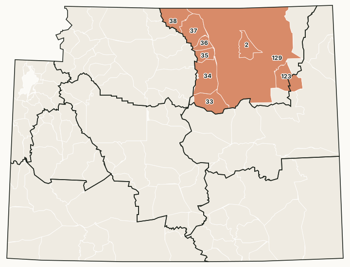
The Sheridan Region covers the east slope of the Bighorn Mountains around Sheridan and Buffalo and the Powder River Basin around Gillette and Wright. Its office is in Sheridan.
Which hunt areas are in the Sheridan Region?
Each hunt area is listed under the region that holds most of it. Some areas cross a region line.
Elk: 9 hunt areas
The elk hunt areas mostly inside the Sheridan Region took 3,144 elk in 2025, by WGFD's report.
| Area | Name | Square miles | Public land | Harvest, latest |
|---|---|---|---|---|
| Area 2 | Fortification | 392 | 32.7% | 224 (2025) |
| Area 33 | Middle Fork | 625 | 51.9% | 120 (2025) |
| Area 34 | Upper Powder River | 826 | 40.2% | 470 (2025) |
| Area 35 | Hunter Mesa | 251 | 75.5% | 143 (2025) |
| Area 36 | Rock Creek | 209 | 67.9% | 145 (2025) |
| Area 37 | Goose | 684 | 52.9% | 282 (2025) |
| Area 38 | Tongue | 564 | 76.5% | 407 (2025) |
| Area 123 | Black Thunder | 626 | 32.5% | 266 (2025) |
| Area 129 | Non-Herd Unit | 7,750 | 18.3% | 1,087 (2025) |
Deer: 19 hunt areas
The deer hunt areas mostly inside the Sheridan Region took 7,324 deer in 2025, by WGFD's report (mule deer and white-tailed deer added together).
| Area | Name | Square miles | Public land | Harvest, latest |
|---|---|---|---|---|
| Area 1 | Crook | 713 | 20.6% | 838 (2025) |
| Area 3 | Keyhole | 331 | 9.9% | 286 (2025) |
| Area 17 | Northwest Gillette | 1,782 | 20.7% | 553 (2025) |
| Area 18 | Campbell | 953 | 22.3% | 289 (2025) |
| Area 19 | Pumpkin Buttes | 1,518 | 13.9% | 224 (2025) |
| Area 21 | Thunder Basin | 851 | 18.1% | 167 (2025) |
| Area 23 | Clearmont | 1,143 | 16% | 1,081 (2025) |
| Area 24 | Sheridan | 491 | 8.2% | 1,680 (2025) |
| Area 25 | Tongue-Goose | 756 | 99.4% | 198 (2025) |
| Area 26 | Ucross | 842 | 25.3% | 320 (2025) |
| Area 27 | Buffalo | 190 | 31.3% | 595 (2025) |
| Area 28 | Hunter Mesa | 342 | 99.6% | 91 (2025) |
| Area 29 | Johnson | 1,002 | 20.1% | 349 (2025) |
| Area 30 | Upper Powder River | 397 | 32.1% | 223 (2025) |
| Area 31 | Salt Creek | 191 | 52% | 20 (2025) |
| Area 32 | Beartrap Creek | 142 | 36.4% | 3 (2025) |
| Area 33 | Red Fork | 430 | 39.9% | 268 (2025) |
| Area 163 | Middle Fork | 176 | 65.3% | 72 (2025) |
| Area 169 | Tisdale Mountain | 236 | 51.4% | 67 (2025) |
Antelope: 17 hunt areas
The antelope hunt areas mostly inside the Sheridan Region took 5,968 antelope in 2025, by WGFD's report.
| Area | Name | Square miles | Public land | Harvest, latest |
|---|---|---|---|---|
| Area 1 | Crook | 713 | 20.6% | 349 (2025) |
| Area 3 | Keyhole | 331 | 9.9% | 193 (2025) |
| Area 10 | Lake De Smet | 179 | 10.6% | 190 (2025) |
| Area 15 | Clearmont | 1,144 | 16% | 271 (2025) |
| Area 16 | Ucross | 663 | 29.3% | 163 (2025) |
| Area 17 | Gillette | 1,774 | 20.8% | 357 (2025) |
| Area 18 | Rockypoint | 542 | 27.6% | 203 (2025) |
| Area 19 | Rozet | 418 | 15.1% | 231 (2025) |
| Area 20 | Upper Powder River | 818 | 39.6% | 172 (2025) |
| Area 21 | Middle Fork | 625 | 51.9% | 213 (2025) |
| Area 22 | Crazy Woman | 862 | 18.8% | 562 (2025) |
| Area 23 | Pumpkin Buttes | 1,542 | 14% | 1,992 (2025) |
| Area 24 | Thunder Basin | 851 | 18.1% | 490 (2025) |
| Area 27 | Bill | 564 | 57.7% | 105 (2025) |
| Area 102 | Buffalo | 463 | 71.5% | 251 (2025) |
| Area 109 | Beckton | 490 | 8.2% | 145 (2025) |
| Area 113 | Salt Creek | 309 | 43.4% | 81 (2025) |
Moose: 2 hunt areas
The moose hunt areas mostly inside the Sheridan Region took 19 moose in 2025, by WGFD's report.
| Area | Name | Square miles | Public land | Harvest, latest |
|---|---|---|---|---|
| Area 1 | Goose Creek | 1,246 | 63.5% | 15 (2025) |
| Area 34 | Hunter Mesa | 945 | 54.2% | 4 (2025) |
Harvest: WGFD harvest reports. Public land measured by FilledTag from USGS PAD-US 4.1 (federal land) and the Office of State Lands and Investments (state trust land).
How much public land is in the Sheridan Region?
| Manager | Acres | Share of the region |
|---|---|---|
| BLM | 974,023 | 11.4% |
| National forest | 861,048 | 10.1% |
| State trust land | 614,569 | 7.2% |
| Other public (state parks, military) | 15,745 | 0.2% |
| National park (no general hunting) | 1,349 | under 0.1% |
In the Office of State Lands and Investments' own parcel layer, the region holds 614,890 acres of state trust land; it classes 259,555 acres as having no known public access and 244,873 acres with road access or access from other state land.
WGFD access areas in the Sheridan Region
WGFD's data places 5 Wildlife Habitat Management Areas, 9 Public Access Areas, 5 Hunter Management Areas and 58 Walk-In Hunting Areas mostly in this region. Those with a page of their own:
- Ed O. Taylor WHMA: 10,211 acres
- Bud Love WHMA: 7,888 acres
- Kerns WHMA: 4,943 acres
- Ogalalla Ranch PAA: 4,310 acres
- Soldier Creek HMA: 3,991 acres
- Ellis WHMA: 3,836 acres
- Amsden Creek WHMA: 3,772 acres
Questions hunters ask
How much public land is in WGFD's Sheridan Region?
28.7% of the region's 8,530,687 acres is public land open to hunting under its manager's rules, measured by FilledTag from USGS PAD-US 4.1 and Office of State Lands data.
How many elk hunt areas are in the Sheridan Region?
9 elk hunt areas lie mostly inside it, along with 19 deer and 17 antelope hunt areas, by WGFD's boundaries.
What WGFD access areas are in the Sheridan Region?
Among others: Amsden Creek WHMA (3,772 acres), Bud Love WHMA (7,888 acres), Ed O. Taylor WHMA (10,211 acres), Ellis WHMA (3,836 acres) and Kerns WHMA (4,943 acres). Each has its own page with WGFD's access dates and rules.
Get notified about FilledTag in Wyoming
Leave your email and we will let you know when FilledTag adds something new for Wyoming hunters.
The free FilledTag app for iPhone has a map that works in every state, Wyoming included.
Where these numbers come from
- Region boundaries: WGFD wildlife administrative regions.
- Harvest: WGFD harvest reports.
- Public land: USGS PAD-US 4.1 (federal land) and the Office of State Lands and Investments (state trust land).
FilledTag is not part of the Wyoming Game and Fish Department. Numbers are copied from WGFD and the other agencies named, or measured by FilledTag from their maps; nothing on this page is estimated by FilledTag. WGFD's regulations are the final word on every rule.
Wyoming hunting Casper Region Cody Region Green River Region Jackson Region Lander Region Laramie Region Pinedale Region