Cody Region: Wyoming hunt areas, harvest and public land
WGFD's Cody Region covers 12,685 square miles and is 72.4% public land. 18 elk, 33 deer and 11 antelope hunt areas lie mostly inside it, and those elk areas took 3,993 elk in 2025 by WGFD's harvest report.
Data updated October 2026. Harvest: WGFD reports to 2025. Land: PAD-US 4.1 and the Office of State Lands. Boundaries: WGFD.
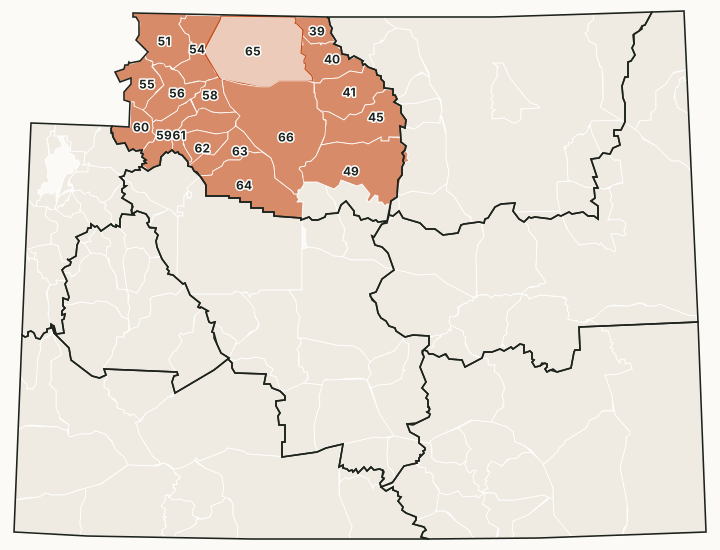
The Cody Region covers the Bighorn Basin, from the Absaroka Range east of Yellowstone National Park to the west slope of the Bighorn Mountains, with Cody, Powell, Worland and Thermopolis inside it. Its office is in Cody. It holds more deer hunt areas than any other region, and bighorn sheep and mountain goat areas in the Absarokas.
Which hunt areas are in the Cody Region?
Each hunt area is listed under the region that holds most of it. Some areas cross a region line.
Elk: 18 hunt areas
The elk hunt areas mostly inside the Cody Region took 3,993 elk in 2025, by WGFD's report.
| Area | Name | Square miles | Public land | Harvest, latest |
|---|---|---|---|---|
| Area 39 | Deer Creek | 230 | 87.5% | 231 (2025) |
| Area 40 | Horse Creek | 462 | 82.2% | 131 (2025) |
| Area 41 | Medicine Lodge | 666 | 84.9% | 356 (2025) |
| Area 45 | Paint Rock Creek | 777 | 82.9% | 314 (2025) |
| Area 49 | Otter Creek | 1,237 | 69.5% | 400 (2025) |
| Area 51 | Sunlight-Crandall | 650 | 97.6% | 120 (2025) |
| Area 54 | Bald Ridge | 523 | 68% | 195 (2025) |
| Area 55 | Grinnell | 392 | 99.8% | 40 (2025) |
| Area 56 | Wapiti Ridge | 473 | 87.7% | 212 (2025) |
| Area 58 | Sage Creek | 255 | 33% | 168 (2025) |
| Area 59 | Boulder Basin | 393 | 91.1% | 307 (2025) |
| Area 60 | Thorofare | 331 | 99.9% | 154 (2025) |
| Area 61 | North Greybull River | 385 | 69.3% | 537 (2025) |
| Area 62 | South Greybull River | 256 | 80% | 187 (2025) |
| Area 63 | Wood River-Gooseberry Creek | 366 | 70.1% | 278 (2025) |
| Area 64 | Owl Creek | 1,022 | 34.8% | 197 (2025) |
| Area 65 | Heart Mountain | 1,679 | 62% | 90 (2025) |
| Area 66 | Basin | 1,915 | 78.2% | 76 (2025) |
Deer: 33 hunt areas
The deer hunt areas mostly inside the Cody Region took 5,313 deer in 2025, by WGFD's report (mule deer and white-tailed deer added together).
| Area | Name | Square miles | Public land | Harvest, latest |
|---|---|---|---|---|
| Area 35 | Upper Nowood | 188 | 37.7% | 31 (2025) |
| Area 37 | Copper Mountain | 372 | 51.4% | 89 (2025) |
| Area 39 | Bates Creek | 254 | 65.1% | 91 (2025) |
| Area 40 | Buffalo Creek | 721 | 55% | 431 (2025) |
| Area 41 | Lower Nowood | 517 | 70.6% | 323 (2025) |
| Area 46 | Cloud Peak | 358 | 99.6% | 100 (2025) |
| Area 47 | Webber Canyon | 559 | 79.3% | 402 (2025) |
| Area 50 | Upper Shell-Beaver Creek | 134 | 100% | 56 (2025) |
| Area 51 | Beaver Creek | 177 | 73.6% | 225 (2025) |
| Area 52 | Crystal Creek | 152 | 76.4% | 42 (2025) |
| Area 53 | Devils Canyon | 230 | 87.5% | 70 (2025) |
| Area 105 | Beartooth | 358 | 82.4% | 175 (2025) |
| Area 106 | Crandall-Sunlight | 488 | 97.6% | 228 (2025) |
| Area 109 | Bald Ridge | 206 | 58.3% | 71 (2025) |
| Area 110 | Grinnell | 392 | 99.8% | 209 (2025) |
| Area 111 | Elk Fork | 431 | 88.6% | 221 (2025) |
| Area 112 | Ishawooa | 227 | 85% | 340 (2025) |
| Area 113 | Boulder | 397 | 49.4% | 304 (2025) |
| Area 114 | Wall Mountain | 182 | 100% | 0 (2025) |
| Area 115 | Thorofare | 329 | 99.9% | 0 (2025) |
| Area 116 | Meeteetse | 373 | 46.2% | 171 (2025) |
| Area 117 | Franc's Peak | 430 | 99.5% | 35 (2025) |
| Area 118 | Upper Gooseberry Creek | 205 | 63% | 32 (2025) |
| Area 119 | Anchor | 439 | 61.7% | 131 (2025) |
| Area 120 | Hamilton Dome | 583 | 14.5% | 127 (2025) |
| Area 121 | Heart Mountain | 464 | 49.1% | 265 (2025) |
| Area 122 | Shoshone River | 992 | 64.2% | 323 (2025) |
| Area 123 | Yellowtail | 38 | 15.7% | 25 (2025) |
| Area 124 | Emblem | 501 | 71.1% | 178 (2025) |
| Area 125 | Fifteen Mile | 952 | 88.4% | 46 (2025) |
| Area 127 | Cottonwood | 265 | 78.3% | 105 (2025) |
| Area 164 | Nowater | 511 | 89.8% | 250 (2025) |
| Area 165 | Yu Bench | 333 | 77.6% | 217 (2025) |
Antelope: 11 hunt areas
The antelope hunt areas mostly inside the Cody Region took 1,989 antelope in 2025, by WGFD's report.
| Area | Name | Square miles | Public land | Harvest, latest |
|---|---|---|---|---|
| Area 76 | Copper Mountain | 515 | 55.4% | 49 (2025) |
| Area 77 | Fifteen Mile Creek | 1,127 | 81.2% | 155 (2025) |
| Area 78 | Mccullough Peaks | 939 | 76.2% | 157 (2025) |
| Area 79 | Big Horn | 1,249 | 77.3% | 119 (2025) |
| Area 80 | Badger Basin | 1,384 | 52.8% | 188 (2025) |
| Area 81 | South Fork | 619 | 57.9% | 262 (2025) |
| Area 82 | North Greybull River | 544 | 68.7% | 373 (2025) |
| Area 83 | Owl Creek | 1,398 | 46.7% | 302 (2025) |
| Area 110 | South Greybull River | 621 | 74.2% | 169 (2025) |
| Area 114 | Nowater | 755 | 86.1% | 60 (2025) |
| Area 115 | Upper Nowood | 1,013 | 53.6% | 155 (2025) |
Moose: 4 hunt areas
The moose hunt areas mostly inside the Cody Region took 19 moose in 2025, by WGFD's report.
| Area | Name | Square miles | Public land | Harvest, latest |
|---|---|---|---|---|
| Area 8 | Thorofare - Yellowstone | 331 | 99.9% | |
| Area 9 | Greybull - Owl Creek | 2,029 | 53.4% | 3 (2025) |
| Area 11 | North Fork | 2,682 | 83.4% | 5 (2025) |
| Area 42 | West Bighorn | 1,963 | 82.4% | 11 (2025) |
Bighorn sheep: 5 hunt areas
The bighorn sheep hunt areas mostly inside the Cody Region took 91 bighorn sheep in 2025, by WGFD's report.
| Area | Name | Square miles | Public land | Harvest, latest |
|---|---|---|---|---|
| Area 1 | Clark's Fork | 694 | 91.7% | 12 (2025) |
| Area 2 | Trout Peak | 786 | 85.2% | 25 (2025) |
| Area 3 | Wapiti Ridge | 712 | 90.9% | 18 (2025) |
| Area 5 | Franc's Peak | 2,649 | 57% | 28 (2025) |
| Area 12 | Porcupine | 230 | 87.5% | 8 (2025) |
Mountain goat: 3 hunt areas
The mountain goat hunt areas mostly inside the Cody Region took 26 mountain goats in 2025, by WGFD's report.
| Area | Name | Square miles | Public land | Harvest, latest |
|---|---|---|---|---|
| Area 1 | Beartooth | 449 | 79% | 10 (2025) |
| Area 3 | North Absaroka | 1,045 | 90.9% | 16 (2025) |
| Area 5 | South Absaroka | 4,825 | 73.1% | 0 (2022) |
Harvest: WGFD harvest reports. Public land measured by FilledTag from USGS PAD-US 4.1 (federal land) and the Office of State Lands and Investments (state trust land).
How much public land is in the Cody Region?
| Manager | Acres | Share of the region |
|---|---|---|
| BLM | 3,183,264 | 39.2% |
| National forest | 2,195,719 | 27% |
| State trust land | 402,598 | 5% |
| Wind River Reservation (as PAD-US maps it) | 270,139 | 3.3% |
| Bureau of Reclamation | 94,772 | 1.2% |
| National park (no general hunting) | 17,864 | 0.2% |
| Other public (state parks, military) | 112 | under 0.1% |
In the Office of State Lands and Investments' own parcel layer, the region holds 405,633 acres of state trust land; it classes 37,444 acres as having no known public access and 229,830 acres with road access or access from other state land.
WGFD access areas in the Cody Region
WGFD's data places 5 Wildlife Habitat Management Areas, 41 Public Access Areas, 14 Hunter Management Areas and 107 Walk-In Hunting Areas mostly in this region. Those with a page of their own:
- Carter Mountain HMA: 80,364 acres
- Pitchfork HMA: 54,566 acres
- Absaroka Front HMA: 28,096 acres
- Yellowtail WHMA: 19,202 acres
- Greybull River HMA: 17,501 acres
- Renner WHMA: 15,725 acres
- Medicine Lodge WHMA: 12,721 acres
- Kirby Creek HMA: 11,503 acres
- Heart Mountain HMA: 9,924 acres
- Spanish Point HMA: 5,489 acres
- Carter/Billy Miles PAA: 4,909 acres
- Sunshine WHMA: 4,616 acres
- Upper Nowood HMA: 3,983 acres
- Newell Springs HMA: 3,223 acres
- Clarks Fork River-Clark Canyon PAA: 2,883 acres
- Deep Creek HMA: 2,000 acres
- Sunlight Basin WHMA: 1,410 acres
Questions hunters ask
How much public land is in WGFD's Cody Region?
72.4% of the region's 8,118,327 acres is public land open to hunting under its manager's rules, measured by FilledTag from USGS PAD-US 4.1 and Office of State Lands data.
How many elk hunt areas are in the Cody Region?
18 elk hunt areas lie mostly inside it, along with 33 deer and 11 antelope hunt areas, by WGFD's boundaries.
What WGFD access areas are in the Cody Region?
Among others: Medicine Lodge WHMA (12,721 acres), Renner WHMA (15,725 acres), Sunlight Basin WHMA (1,410 acres), Sunshine WHMA (4,616 acres) and Yellowtail WHMA (19,202 acres). Each has its own page with WGFD's access dates and rules.
Get notified about FilledTag in Wyoming
Leave your email and we will let you know when FilledTag adds something new for Wyoming hunters.
The free FilledTag app for iPhone has a map that works in every state, Wyoming included.
Where these numbers come from
- Region boundaries: WGFD wildlife administrative regions.
- Harvest: WGFD harvest reports.
- Public land: USGS PAD-US 4.1 (federal land) and the Office of State Lands and Investments (state trust land).
FilledTag is not part of the Wyoming Game and Fish Department. Numbers are copied from WGFD and the other agencies named, or measured by FilledTag from their maps; nothing on this page is estimated by FilledTag. WGFD's regulations are the final word on every rule.
Wyoming hunting Casper Region Green River Region Jackson Region Lander Region Laramie Region Pinedale Region Sheridan Region