Jackson Region: Wyoming hunt areas, harvest and public land
WGFD's Jackson Region covers 4,086 square miles and is 78.7% public land. 18 elk, 9 deer and 1 antelope hunt areas lie mostly inside it, and those elk areas took 2,629 elk in 2025 by WGFD's harvest report.
Data updated October 2026. Harvest: WGFD reports to 2025. Land: PAD-US 4.1 and the Office of State Lands. Boundaries: WGFD.
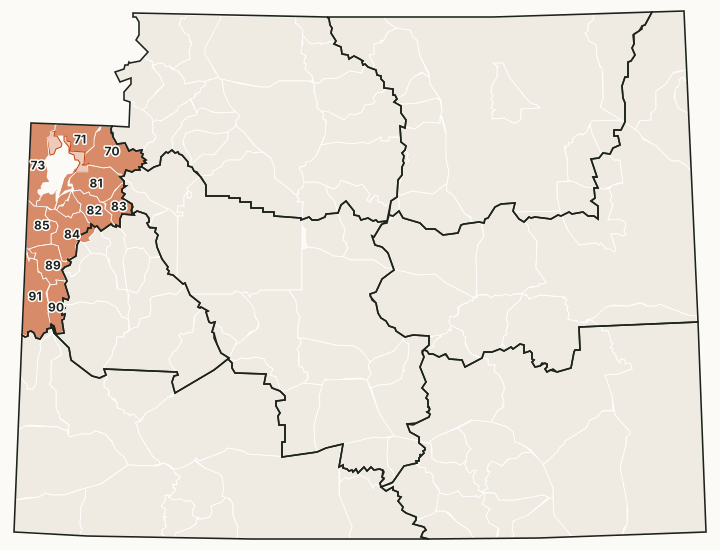
The Jackson Region is the smallest of the eight: Jackson Hole and the mountains around it, south of Yellowstone, and Star Valley along the Idaho line around Afton, Thayne and Alpine. Its office is in Jackson. National forest covers most of it, and it holds more moose hunt areas than any other region.
Which hunt areas are in the Jackson Region?
Each hunt area is listed under the region that holds most of it. Some areas cross a region line.
Elk: 18 hunt areas
The elk hunt areas mostly inside the Jackson Region took 2,629 elk in 2025, by WGFD's report.
| Area | Name | Square miles | Public land | Harvest, latest |
|---|---|---|---|---|
| Area 70 | Buffalo Fork | 448 | 99.1% | 218 (2025) |
| Area 71 | Pacific Creek | 234 | 84% | 108 (2025) |
| Area 72 | Berry Creek | 60 | 0.6% | |
| Area 73 | Targhee-Alta | 382 | 96.2% | 57 (2025) |
| Area 75 | Snake River | 47 | 1.9% | 13 (2025) |
| Area 77 | National Elk Refuge | 39 | 0% | 36 (2025) |
| Area 78 | Wilson | 71 | 36% | 106 (2025) |
| Area 79 | Teton Park | 65 | 0.5% | |
| Area 80 | Sheep Creek | 89 | 98.6% | 7 (2025) |
| Area 81 | Spread Creek | 351 | 98.8% | 147 (2025) |
| Area 82 | Crystal Peak | 234 | 99% | 147 (2025) |
| Area 83 | Fish Creek | 161 | 99.9% | 116 (2025) |
| Area 84 | Lower Hoback | 395 | 91.4% | 499 (2025) |
| Area 85 | Fall Creek | 280 | 92.3% | 258 (2025) |
| Area 88 | Greys Feedground | 18 | 63.4% | 32 (2025) |
| Area 89 | Lower Greys River | 263 | 99.8% | 253 (2025) |
| Area 90 | Upper Greys River | 221 | 100% | 116 (2025) |
| Area 91 | Salt River | 465 | 60.5% | 516 (2025) |
Deer: 9 hunt areas
The deer hunt areas mostly inside the Jackson Region took 870 deer in 2025, by WGFD's report (mule deer and white-tailed deer added together).
| Area | Name | Square miles | Public land | Harvest, latest |
|---|---|---|---|---|
| Area 144 | Greys River | 484 | 99.9% | 208 (2025) |
| Area 145 | Salt River | 484 | 60.7% | 260 (2025) |
| Area 148 | Teton | 684 | 93.9% | 53 (2025) |
| Area 149 | Targhee | 382 | 96.2% | 23 (2025) |
| Area 150 | Wilson | 71 | 35.7% | 6 (2025) |
| Area 151 | Fall Creek | 280 | 92.3% | 42 (2025) |
| Area 152 | Lower Hoback | 396 | 91.4% | 181 (2025) |
| Area 155 | Crystal Peak | 451 | 90.6% | 48 (2025) |
| Area 156 | Spread Creek | 422 | 99% | 49 (2025) |
Antelope: 1 hunt area
WGFD's 2025 report shows no antelope harvest in these areas; the latest year each was reported is shown.
| Area | Name | Square miles | Public land | Harvest, latest |
|---|---|---|---|---|
| Area 85 | Gros Ventre | 873 | 94.7% | 20 (2022) |
Moose: 13 hunt areas
The moose hunt areas mostly inside the Jackson Region took 38 moose in 2025, by WGFD's report.
| Area | Name | Square miles | Public land | Harvest, latest |
|---|---|---|---|---|
| Area 7 | Buffalo River | 216 | 100% | |
| Area 14 | Fox Park | 169 | 99.9% | |
| Area 15 | Glade Creek - Pilgrim Creek | 136 | 72.7% | |
| Area 16 | Alta | 195 | 93.4% | 2 (2025) |
| Area 17 | Lower Gros Ventre - Spread Creek | 364 | 98.9% | 5 (2025) |
| Area 18 | Fish Creek | 161 | 99.9% | 8 (2025) |
| Area 19 | Wilson | 37 | 3.9% | |
| Area 20 | Fall Creek - Targee | 315 | 89.7% | 14 (2025) |
| Area 21 | North Hoback | 303 | 89.6% | 2 (2025) |
| Area 23 | Grey's River - Salt River | 969 | 80.3% | 7 (2025) |
| Area 28 | Crystal Creek - Flat Creek | 270 | 98.9% | 0 (2025) |
| Area 32 | Enos Lake | 147 | 97.7% | |
| Area 37 | Grassy Lake | 187 | 99.2% | 0 (2025) |
Bighorn sheep: 3 hunt areas
The bighorn sheep hunt areas mostly inside the Jackson Region took 68 bighorn sheep in 2025, by WGFD's report.
| Area | Name | Square miles | Public land | Harvest, latest |
|---|---|---|---|---|
| Area 4 | Yount's Peak | 1,327 | 99.3% | 17 (2025) |
| Area 6 | Targhee | 406 | 96.5% | 0 (2025) |
| Area 7 | Jackson | 1,662 | 95.7% | 51 (2025) |
Mountain goat: 2 hunt areas
The mountain goat hunt areas mostly inside the Jackson Region took 1 mountain goat in 2025, by WGFD's report.
| Area | Name | Square miles | Public land | Harvest, latest |
|---|---|---|---|---|
| Area 2 | Palisades | 280 | 92.3% | 1 (2025) |
| Area 4 | Targhee | 406 | 96.5% | 0 (2023) |
Harvest: WGFD harvest reports. Public land measured by FilledTag from USGS PAD-US 4.1 (federal land) and the Office of State Lands and Investments (state trust land).
How much public land is in the Jackson Region?
| Manager | Acres | Share of the region |
|---|---|---|
| National forest | 2,042,988 | 78.1% |
| National park (no general hunting) | 298,885 | 11.4% |
| National wildlife refuge | 24,730 | 0.9% |
| State trust land | 9,467 | 0.4% |
| BLM | 5,940 | 0.2% |
| Bureau of Reclamation | 226 | under 0.1% |
In the Office of State Lands and Investments' own parcel layer, the region holds 9,523 acres of state trust land; it classes 314 acres as having no known public access and 5,922 acres with road access or access from other state land.
WGFD access areas in the Jackson Region
WGFD's data places 7 Wildlife Habitat Management Areas, 18 Public Access Areas, 1 Hunter Management Area and 6 Walk-In Hunting Areas mostly in this region. Those with a page of their own:
- Greys River WHMA: 3,042 acres
- South Park WHMA: 1,006 acres
- Teton WHMA: 974 acres
Questions hunters ask
How much public land is in WGFD's Jackson Region?
78.7% of the region's 2,615,231 acres is public land open to hunting under its manager's rules, measured by FilledTag from USGS PAD-US 4.1 and Office of State Lands data.
How many elk hunt areas are in the Jackson Region?
18 elk hunt areas lie mostly inside it, along with 9 deer and 1 antelope hunt areas, by WGFD's boundaries.
What WGFD access areas are in the Jackson Region?
Among others: Greys River WHMA (3,042 acres), South Park WHMA (1,006 acres) and Teton WHMA (974 acres). Each has its own page with WGFD's access dates and rules.
Get notified about FilledTag in Wyoming
Leave your email and we will let you know when FilledTag adds something new for Wyoming hunters.
The free FilledTag app for iPhone has a map that works in every state, Wyoming included.
Where these numbers come from
- Region boundaries: WGFD wildlife administrative regions.
- Harvest: WGFD harvest reports.
- Public land: USGS PAD-US 4.1 (federal land) and the Office of State Lands and Investments (state trust land).
FilledTag is not part of the Wyoming Game and Fish Department. Numbers are copied from WGFD and the other agencies named, or measured by FilledTag from their maps; nothing on this page is estimated by FilledTag. WGFD's regulations are the final word on every rule.
Wyoming hunting Casper Region Cody Region Green River Region Lander Region Laramie Region Pinedale Region Sheridan Region