Elk Hunt Area 91, Salt River: harvest, draw results and public land
Elk Hunt Area 91 (Salt River) covers 465 square miles in WGFD's Jackson Region and is 60.5% public land, most of it national forest (172,310 acres), measured from USGS PAD-US 4.1 and Office of State Lands data. WGFD's 2025 harvest report estimates 1,283 active hunters took 516 elk here, 40.2% success. The 2026 season table lists 8 license rows here, including general license seasons.
Data updated October 2026. Harvest: WGFD reports for 2021 to 2025. Seasons: WGFD Commission Chapter 7, final April 2026. Draw: WGFD 2026 demand reports. Land: PAD-US 4.1 and the Office of State Lands, read 2026-10-18.
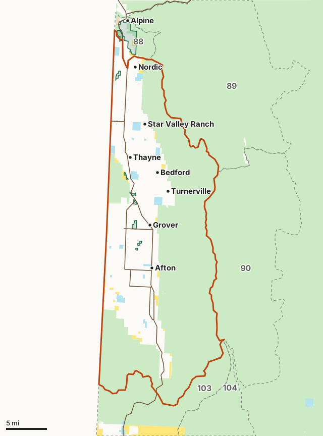
National forestBLMState trust landArea 91Neighboring areasWGFD access areaLakeHighway
| WGFD region | Jackson Region |
|---|---|
| Herd unit | Afton (105) |
| Size | 465 square miles (297,699 acres) |
| Public land | 60.5% (180,226 acres) |
| Harvest, 2025 | 516 (40.2% of 1,283 active hunters) |
| General license seasons, 2026 | Oct 15 to Oct 31 (Any elk); Nov 1 to Nov 15 (Antlerless elk) |
| Limited quota license types, 2026 | Type 1, Type 6, Type 7 |
| Special archery opens | September 1 |
| Towns in and near it | Afton, Star Valley Ranch, Thayne and Alpine |
How much public land is in Elk Area 91?
60.5% of elk Area 91 is public land open to hunting under its manager's rules: 180,226 of 297,699 acres. The largest share is national forest, 172,310 acres or 57.9% of the area.
| Manager | Acres | Share of Area 91 |
|---|---|---|
| National forest | 172,310 | 57.9% |
| State trust land | 4,847 | 1.6% |
| BLM | 3,069 | 1% |
State trust land by access: the Office of State Lands and Investments' own parcel layer has 4,894 acres here (a few parcels overlap federal land in the source maps, so this can differ a little from the table). 3,632 acres road access or reached from other state land, 1,059 acres next to other public land and 203 acres no known public access. State trust land is open to hunting where it can be reached legally, but not to camping or open fires.
WGFD access areas in Elk Area 91
Public Access Areas: Salt River-A/G Lane (250 acres here), Salt River-Miller's (180 acres here), Salt River-Narrows Bridge (81 acres here), Salt River-Willow Creek (59 acres here), Salt River-Diversion (45 acres here) and Salt River-Burton's Upper (40 acres here) and 3 more. Walk-In Hunting: 4 areas covering 1,735 acres of private land enrolled in WGFD's Access Yes program.
Measured by FilledTag inside WGFD's hunt area boundary (WGFD elk hunt areas) from USGS PAD-US 4.1 (federal land) and the Office of State Lands and Investments (state trust land). Access areas: WGFD's WHMA, PAA, HMA and Walk-In boundaries. Wilderness: USFS wilderness boundaries as WGFD publishes them.
How many elk are harvested in Elk Area 91?
WGFD estimates 516 elk were taken in elk Area 91 in 2025: 192 bulls, 14 spikes, 258 cows and 52 calves. 1,283 hunters hunted, and 40.2% of them took an animal. Residents: 1,080 hunters, 39.9% success; nonresidents: 203 hunters, 41.9% success.
| Year | Active hunters | Harvest | Bulls | Spikes | Cows | Calves | Hunter success | Hunter days | Days per animal |
|---|---|---|---|---|---|---|---|---|---|
| 2025 | 1,283 | 516 | 192 | 14 | 258 | 52 | 40.2% | 9,114 | 17.7 |
| 2024 | 1,233 | 462 | 197 | 6 | 196 | 63 | 37.5% | 7,802 | 16.9 |
| 2023 | 1,045 | 453 | 173 | 25 | 212 | 43 | 43.3% | 7,374 | 16.3 |
| 2022 | 1,053 | 404 | 167 | 8 | 213 | 16 | 38.4% | 6,309 | 15.6 |
| 2021 | 1,104 | 470 | 220 | 16 | 183 | 51 | 42.6% | 6,901 | 14.7 |
| License type | Licenses sold | Active licenses | Harvest | Success | Days |
|---|---|---|---|---|---|
| Type 1 | 101 | 97 | 59 | 60.8% | 917 |
| Type 6 | 351 | 283 | 171 | 60.4% | 2,379 |
| Type 7 | 101 | 86 | 50 | 58.1% | 446 |
| General | not limited | 912 | 236 | 25.9% | 5,372 |
Source: WGFD 2025 elk harvest report, page 17 of the PDF; earlier years from 2024, 2023, 2022 and 2021. WGFD counts a hunter as active if he hunted. Days per animal is worked out from WGFD's own two figures. A bull, in WGFD's tables, is a branch-antlered bull; spikes are counted apart.
When is elk season in Elk Area 91 in 2026?
General license seasons: October 15 to 31 (any elk); November 1 to 15 (antlerless elk). Special archery seasons open September 1. Every row WGFD prints for Area 91:
| License type | Special archery season | Regular season | Quota | WGFD's limitations |
|---|---|---|---|---|
| General | Sep 1 to Sep 30 | Oct 15 to Oct 31 | Any elk | |
| General | Nov 1 to Nov 15 | Antlerless elk | ||
| Type 1 | Sep 1 to Sep 30 | Oct 1 to Oct 31 | 100 | Any elk |
| Type 1 | Nov 1 to Dec 31 | Antlerless elk | ||
| Type 1 | Jan 1 to Jan 31 | Antlerless elk valid off national forest | ||
| Type 6 | Sep 1 to Sep 30 | Oct 1 to Dec 31 | 350 | Cow or calf |
| Type 6 | Jan 1 to Jan 31 | Cow or calf valid off national forest | ||
| Type 7 | Sep 1 to Sep 30 | Oct 1 to Jan 31 | 100 | Cow or calf valid off national forest west of U.S. Highway 89 and south of Wyoming Highway 239 |
Source: WGFD Commission Chapter 7 (final, April 2026), page 15. WGFD can change a season by emergency rule: check WGFD's regulations page before you go.
What did the 2026 draw look like in Elk Area 91?
From WGFD's 2026 initial drawing demand reports: each limited quota hunt's licenses, its first-choice applicants in each drawing, how many were drawn in the preference point drawings, and the fewest points that drew. WGFD does not publish how many drew in the random drawings. The rules for points and the deadlines are on the Wyoming draw page.
| Drawing | Licenses | First-choice applicants | Drawn | Fewest points that drew |
|---|---|---|---|---|
| Nonresidents, regular, random | 1 | 42 | not published | |
| Nonresidents, special, random | 1 | 12 | not published | |
| Residents | 84 | 286 | not published | |
| Nonresidents, regular, preference points | 5 | 47 | 5 | 8 |
| Nonresidents, special, preference points | 4 | 16 | 4 | 13 |
| Drawing | Licenses | First-choice applicants | Drawn | Fewest points that drew |
|---|---|---|---|---|
| Nonresidents, reduced price, random | 54 | 166 | not published | |
| Residents | 294 | 546 | not published |
| Drawing | Licenses | First-choice applicants | Drawn | Fewest points that drew |
|---|---|---|---|---|
| Nonresidents, reduced price, random | 16 | 5 | not published | |
| Residents | 86 | 25 | not published |
Nonresidents hunt the general license here on WGFD's Region W general license. In the 2026 draw it had 2,683 licenses; 5,652 nonresidents put it first in the regular preference point drawing and 1,208 were drawn.
Source: WGFD 2026 elk demand report, nonresident preference point drawing and the other 2026 demand reports on WGFD's draw results page. Applicants who miss in a nonresident preference point drawing go on to the random drawing, so one person can be counted in both.
How do you get to Elk Area 91?
Highways through the area: US 89 (about 43 miles inside it), WY 238 (about 12 miles inside it), WY 236 (about 5 miles inside it), WY 241 (about 4 miles inside it) and WY 237 (about 4 miles inside it). Towns inside: Afton, Star Valley Ranch, Thayne, Nordic, Bedford and Turnerville. Nearby: Alpine (2 miles).
Which elk hunt areas border Area 91?
Elk Area 91 touches 5 other elk hunt areas. Their size, public land and latest WGFD harvest, for comparison:
| Hunt area | Name | Square miles | Public land | Harvest (year) |
|---|---|---|---|---|
| Area 88 | Greys Feedground | 18 | 63.4% | 32 (2025) |
| Area 89 | Lower Greys River | 263 | 99.8% | 253 (2025) |
| Area 90 | Upper Greys River | 221 | 100% | 116 (2025) |
| Area 103 | Raymond Mountain | 265 | 76.5% | 308 (2025) |
| Area 104 | Lincoln | 676 | 71.2% | 588 (2025) |
Questions hunters ask
How much public land is in Elk Area 91?
60.5% of elk Area 91 is public land: 180,226 of its 297,699 acres, the largest share national forest (172,310 acres). Measured by FilledTag inside WGFD's boundary from USGS PAD-US 4.1 and Office of State Lands data.
What is the hunter success in Elk Area 91?
WGFD's 2025 harvest report puts hunter success at 40.2%: 1,283 active hunters took 516 elk. In 2024 it was 37.5% (462 taken). WGFD estimates these numbers from its hunter survey.
When does elk season open in Elk Area 91 in 2026?
The special archery season opens September 1. The earliest regular season row opens October 1 and the latest closes January 31, by WGFD Commission Chapter 7. Each license type has its own dates and limitations, listed on this page.
How many licenses were in the 2026 draw for Elk Area 91?
WGFD's 2026 demand reports list 3 limited quota hunts for elk Area 91. The largest, Type 6, had 348 licenses and 712 first-choice applicants across its drawings.
What is the closest town to Elk Area 91?
Afton, Star Valley Ranch and Thayne are inside the hunt area. Just outside: Alpine (2 miles).
Get notified about FilledTag in Wyoming
Leave your email and we will let you know when FilledTag adds something new for Wyoming hunters.
The free FilledTag app for iPhone has a map that works in every state, Wyoming included.
Where these numbers come from
- Harvest, hunters and days: WGFD elk harvest reports, 2021 to 2025, listed here.
- Seasons, quotas and limitations: WGFD Commission Chapter 7 (final, April 2026), page 15.
- Draw: WGFD 2026 demand reports; deadlines and fees on the Wyoming draw page.
- Hunt area boundary: WGFD elk hunt areas. Public land: USGS PAD-US 4.1 (federal land) and the Office of State Lands and Investments (state trust land). Highways and towns: Census TIGER/Line 2024 and the 2024 Gazetteer.
FilledTag is not part of the Wyoming Game and Fish Department. Numbers are copied from WGFD and the other agencies named, or measured by FilledTag from their maps; nothing on this page is estimated by FilledTag. WGFD's regulations are the final word on every rule.
Wyoming hunting Elk hunt areas Jackson Region Area 88 Area 89 Area 90 Area 103 Area 104