Wyoming moose hunt areas: harvest, seasons and public land
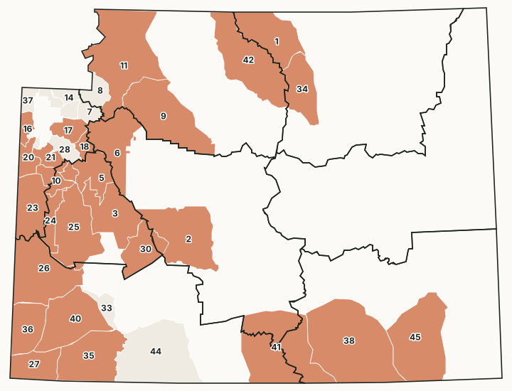
WGFD divides Wyoming into 38 moose hunt areas. Its 2025 harvest report estimates hunters took 338 moose statewide. The most were taken in Area 38 (53), Area 25 (48) and Area 26 (42).
Data updated October 2026. Harvest: WGFD reports to 2025. Seasons: Chapter 8, final April 2026. Land: PAD-US 4.1 and the Office of State Lands.
How many moose are harvested in Wyoming?
| Year | Moose harvested |
|---|---|
| 2025 | 338 |
| 2024 | 317 |
| 2023 | 331 |
| 2022 | 334 |
| 2021 | 329 |
Source: WGFD's statewide tables in its annual harvest reports, 2021 to 2025. FilledTag checked that every year's hunt area rows add up to WGFD's statewide figure before using them.
Every Wyoming moose hunt area
38 areas, with WGFD's latest harvest and hunter success, measured public land and whether the 2026 table has a general license season.
| Area | Name | Region | Square miles | Public land | Harvest, latest | Success | General license, 2026 |
|---|---|---|---|---|---|---|---|
| Area 1 | Goose Creek | Sheridan | 1,246 | 63.5% | 15 | 83.3% | No |
| Area 2 | Lander Area | Lander | 1,810 | 83.1% | 4 | 100% | No |
| Area 3 | Pinedale | Pinedale | 1,247 | 74.9% | 15 | 100% | No |
| Area 5 | Upper Green River | Pinedale | 658 | 92.9% | 18 | 100% | No |
| Area 6 | Wind River | Lander | 1,246 | 84.8% | 5 | 100% | No |
| Area 7 | Buffalo River | Jackson | 216 | 100% | Closed | ||
| Area 8 | Thorofare - Yellowstone | Cody | 331 | 99.9% | Closed | ||
| Area 9 | Greybull - Owl Creek | Cody | 2,029 | 53.4% | 3 | 100% | No |
| Area 10 | South Hoback | Pinedale | 321 | 93.4% | 6 | 85.7% | No |
| Area 11 | North Fork | Cody | 2,682 | 83.4% | 5 | 100% | No |
| Area 14 | Fox Park | Jackson | 169 | 99.9% | Closed | ||
| Area 15 | Glade Creek - Pilgrim Creek | Jackson | 136 | 72.7% | Closed | ||
| Area 16 | Alta | Jackson | 195 | 93.4% | 2 | 40% | No |
| Area 17 | Lower Gros Ventre - Spread Creek | Jackson | 364 | 98.9% | 5 | 100% | No |
| Area 18 | Fish Creek | Jackson | 161 | 99.9% | 8 | 100% | No |
| Area 19 | Wilson | Jackson | 37 | 3.9% | Closed | ||
| Area 20 | Fall Creek - Targee | Jackson | 315 | 89.7% | 14 | 100% | No |
| Area 21 | North Hoback | Jackson | 303 | 89.6% | 2 | 100% | No |
| Area 22 | Raspberry Ridge | Pinedale | 115 | 91.3% | 5 | 100% | No |
| Area 23 | Grey's River - Salt River | Jackson | 969 | 80.3% | 7 | 70% | No |
| Area 24 | Big Piney - On National Forest | Pinedale | 382 | 99.7% | 16 | 94.1% | No |
| Area 25 | Big Piney - Off National Forest | Pinedale | 1,492 | 63.8% | 48 | 96% | No |
| Area 26 | Lincoln | Green River | 1,799 | 78.7% | 42 | 96% | No |
| Area 27 | Uinta | Green River | 732 | 24.4% | 16 | 100% | No |
| Area 28 | Crystal Creek - Flat Creek | Jackson | 270 | 98.9% | 0 | No | |
| Area 30 | Sweetwater | Pinedale | 805 | 91.8% | 1 | 100% | No |
| Area 32 | Enos Lake | Jackson | 147 | 97.7% | Closed | ||
| Area 33 | Lower Green River | Green River | 277 | 56.3% | 5 | 100% | |
| Area 34 | Hunter Mesa | Sheridan | 945 | 54.2% | 4 | 100% | No |
| Area 35 | Henry's Fork | Green River | 1,525 | 69.7% | 5 | 100% | No |
| Area 36 | Bear River Divide | Green River | 842 | 55.8% | 5 | 100% | No |
| Area 37 | Grassy Lake | Jackson | 187 | 99.2% | 0 | No | |
| Area 38 | Snowy Range | Laramie | 3,235 | 42.8% | 53 | 85.5% | No |
| Area 40 | Lower Hams Fork | Green River | 1,524 | 53% | 6 | 100% | No |
| Area 41 | Sierra Madres | Green River | 2,745 | 62.9% | 5 | 100% | No |
| Area 42 | West Bighorn | Cody | 1,963 | 82.4% | 11 | 91.7% | No |
| Area 44 | East Flaming Gorge | Green River | 2,304 | 71.7% | 0 | ||
| Area 45 | Pole Mountain | Laramie | 2,176 | 15.7% | 7 | 100% | No |
Harvest: WGFD harvest reports (latest year each area was reported). Seasons: WGFD Commission Chapter 8 (final, April 2026). Public land measured by FilledTag from USGS PAD-US 4.1 (federal land) and the Office of State Lands and Investments (state trust land).
Moose seasons in 2026, area by area
Every moose row in WGFD Commission Chapter 8 for 2026: the license type, the special archery and regular season dates, the quota and WGFD's limitations.
| Area | Type | Special archery | Regular season | Quota | WGFD's limitations |
|---|---|---|---|---|---|
| Area 1 | Type 1 | Sep 1 to Sep 30 | Oct 1 to Oct 31 | 9 | Any moose, except cow moose with calf at side |
| Area 1 | Type 4 | Sep 1 to Sep 30 | Oct 1 to Oct 31 | 17 | Antlerless moose, except cow moose with calf at side |
| Area 2, 30 | Type 1 | Sep 1 to Sep 30 | Oct 1 to Nov 20 | 5 | Antlered moose |
| Area 3 | Type 1 | Sep 1 to Sep 19 | Sep 20 to Oct 31 | 15 | Antlered moose |
| Area 5 | Type 1 | Sep 1 to Sep 30 | Oct 1 to Oct 31 | 20 | Antlered moose |
| Area 6 | Type 1 | Sep 1 to Sep 30 | Oct 1 to Nov 20 | 5 | Antlered moose |
| Area 7 | Closed | ||||
| Area 8 | Closed | ||||
| Area 9 | Type 1 | Sep 1 to Sep 9 | Sep 10 to Nov 10 | 3 | Antlered moose |
| Area 10 | Type 1 | Sep 1 to Sep 14 | Sep 15 to Oct 31 | 8 | Antlered moose |
| Area 11 | Type 1 | Sep 1 to Sep 9 | Sep 10 to Nov 10 | 5 | Antlered moose |
| Area 14 | Closed | ||||
| Area 15 | Closed | ||||
| Area 16, 37 | Type 1 | Sep 1 to Sep 14 | Sep 15 to Nov 15 | 5 | Antlered moose |
| Area 17, 28 | Type 1 | Sep 1 to Sep 14 | Sep 15 to Nov 15 | 5 | Antlered moose |
| Area 18 | Type 1 | Sep 1 to Sep 30 | Oct 1 to Nov 15 | 5 | Antlered moose |
| Area 19 | Closed | ||||
| Area 20 | Type 1 | Sep 1 to Sep 14 | Sep 15 to Oct 31 | 15 | Antlered moose |
| Area 21 | Type 1 | Sep 1 to Sep 14 | Sep 15 to Oct 31 | 2 | Antlered moose |
| Area 22 | Type 1 | Sep 1 to Sep 30 | Oct 1 to Oct 31 | 5 | Antlered moose |
| Area 23 | Type 1 | Sep 1 to Sep 14 | Sep 15 to Oct 31 | 10 | Antlered moose |
| Area 24 | Type 1 | Sep 1 to Sep 14 | Sep 15 to Oct 31 | 20 | Antlered moose |
| Area 25 | Type 1 | Sep 1 to Sep 30 | Oct 1 to Oct 31 | 45 | Antlered moose |
| Area 25 | Type 4 | Sep 1 to Sep 30 | Oct 1 to Oct 31 | 5 | Antlerless moose, except cow moose with calf at side |
| Area 26 | Type 1 | Aug 15 to Aug 31 | Antlered moose, valid on private irrigated land within the LaBarge Creek drainage | ||
| Area 26 | Type 1 | Sep 1 to Sep 30 | Oct 1 to Oct 31 | 40 | Antlered moose, valid in the entire area |
| Area 26 | Type 4 | Aug 15 to Aug 31 | Antlerless moose, except cow moose with calf at side; valid on private irrigated land within the LaBarge Creek drainage | ||
| Area 26 | Type 4 | Sep 1 to Sep 30 | Oct 1 to Oct 31 | 5 | Antlerless moose, except cow moose with calf at side; valid on private irrigated land |
| Area 27 | Type 1 | Sep 1 to Sep 30 | Oct 1 to Nov 20 | 12 | Antlered moose |
| Area 32 | Closed | ||||
| Area 34 | Type 1 | Sep 1 to Sep 30 | Oct 1 to Oct 31 | 3 | Any moose, except cow moose with calf at side |
| Area 34 | Type 4 | Sep 1 to Sep 30 | Oct 1 to Oct 31 | 1 | Antlerless moose, except cow moose with calf at side |
| Area 35 | Type 1 | Sep 1 to Sep 30 | Oct 1 to Nov 20 | 3 | Antlered moose |
| Area 36 | Type 1 | Sep 1 to Sep 30 | Oct 1 to Oct 31 | 5 | Antlered moose |
| Area 38 | Type 1 | Sep 1 to Sep 30 | Oct 1 to Nov 30 | 30 | Any moose, except cow moose with calf at side |
| Area 38 | Type 4 | Sep 1 to Sep 30 | Oct 1 to Nov 30 | 35 | Antlerless moose, except cow moose with calf at side |
| Area 40 | Type 1 | Sep 1 to Sep 30 | Oct 1 to Oct 31 | 3 | Antlered moose |
| Area 40 | Type 4 | Sep 1 to Sep 30 | Oct 1 to Oct 31 | 3 | Antlerless moose, except cow moose with calf at side |
| Area 41 | Type 1 | Sep 1 to Sep 30 | Oct 1 to Nov 30 | 5 | Any moose, except cow moose with calf at side |
| Area 41 | Type 4 | Sep 1 to Sep 30 | Oct 1 to Nov 30 | 3 | Antlerless moose, except cow moose with calf at side |
| Area 42 | Type 1 | Sep 1 to Sep 30 | Oct 1 to Oct 31 | 8 | Any moose, except cow moose with calf at side |
| Area 42 | Type 4 | Sep 1 to Sep 30 | Oct 1 to Oct 31 | 2 | Antlerless moose, except cow moose with calf at side |
| Area 45 | Type 1 | Sep 1 to Sep 30 | Oct 1 to Nov 30 | 5 | Any moose, except cow moose with calf at side |
| Area 45 | Type 4 | Sep 1 to Sep 30 | Oct 1 to Nov 30 | 2 | Antlerless moose, except cow moose with calf at side |
Source: WGFD Commission Chapter 8 (final, April 2026).
Questions hunters ask
How many moose hunt areas does Wyoming have?
WGFD's moose hunt area map has 38 areas in 2026. 6 of them are closed in 2026 by Chapter 8.
How many moose were harvested in Wyoming in 2025?
WGFD estimates 338 moose statewide in 2025.
Which Wyoming moose hunt areas had the most harvest in 2025?
Area 38 Snowy Range (53), Area 25 Big Piney - Off National Forest (48) and Area 26 Lincoln (42), by WGFD's 2025 report.
Get notified about FilledTag in Wyoming
Leave your email and we will let you know when FilledTag adds something new for Wyoming hunters.
The free FilledTag app for iPhone has a map that works in every state, Wyoming included.
Where these numbers come from
- Hunt areas: WGFD moose hunt areas (2026).
- Harvest: WGFD harvest reports.
- Seasons: WGFD Commission Chapter 8 (final, April 2026).
- Public land: USGS PAD-US 4.1 (federal land) and the Office of State Lands and Investments (state trust land).
FilledTag is not part of the Wyoming Game and Fish Department. Numbers are copied from WGFD and the other agencies named, or measured by FilledTag from their maps; nothing on this page is estimated by FilledTag. WGFD's regulations are the final word on every rule.
Wyoming hunting Elk Deer Antelope Bighorn sheep Mountain goat