Connor O. Fewel Conservation Area: hunting and access
Connor O. Fewel Conservation Area is 315 acres of MDC land in Henry County, 4 miles from Calhoun. MDC lists deer hunting here (muzzleloader and archery, antlerless permits allowed). Hunters checked 3,300 deer in Henry County in 2025.
Data updated October 2026. Area facts: MDC's conservation area data, read 2026-10. Harvest: MDC deer harvest summaries, 2021 to 2025.
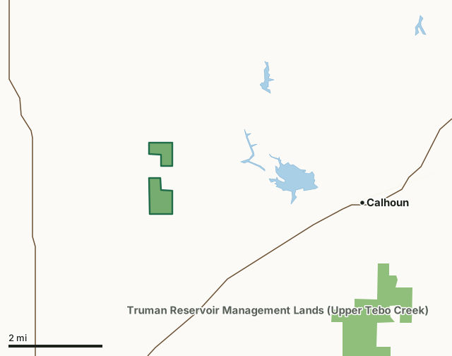
MDC conservation areasFederal land, mostly Corps of Engineers lakesState parks and historic sitesConnor O. Fewel Conservation AreaCounty lineLakeHighway
| Size | 315 acres in 2 pieces |
|---|---|
| County | Henry County |
| Deer harvest unit | Henry County |
| MDC lists for hunting | Deer, Bear, Turkey, Rabbit, Squirrel, Dove and Quail |
| MDC area number | 7803 |
| MDC region | Kansas City |
| Nearest towns | Calhoun (4 mi), Leeton (7 mi) and Clinton (7 mi) |
What is Connor O. Fewel Conservation Area like?
Connor O. Fewel Conservation Area is in northern Henry County, north of Lewis on Route AC.
The area has a rich and varied history. An Osage Indian trail once ran by the springs, connecting Kansas City to Warsaw. Settlers also used the area as a community meeting place; evidence of their gatherings remain in the form of circular stone tables, campfire circles, and initials scratched into moss-covered rock overhangs. The outlaw Jesse James and the Younger Gang reportedly hid out near here, and a tree near the springs was said to be a "hanging tree" during those lawless times. Connor O. Fewel Conservation Area is divided into north and south units, by a block of privately-owned land. The southern unit is characterized by crop fields, brushy draws, and reclaimed mine spoils. The north unit primarily consists of mature oak and hickory timber on rolling hills. The area features a wide variety of habitat and wildlife.
In MDC's words, from the Connor O. Fewel Conservation Area page.
What can you hunt on Connor O. Fewel Conservation Area?
MDC's page for Connor O. Fewel Conservation Area lists: Deer: muzzleloader and archery, antlerless permits allowed; Bear: archery and firearms; Turkey: archery and firearms; Rabbit; Squirrel; Dove; Quail.
What are the rules on Connor O. Fewel Conservation Area?
MDC's standard conservation area rules (Chapter 11 of the Wildlife Code) apply; the area's rules on MDC's site list any it adds.
How many deer are taken around Connor O. Fewel Conservation Area?
Connor O. Fewel Conservation Area lies in Henry County. Hunters checked 3,300 deer in Henry County in 2025, against 3,293 in 2024.
| County | Connor O. Fewel Conservation Area acres in it | Deer, 2025 | Deer, 2024 | Deer, 2023 |
|---|---|---|---|---|
| Henry County | 315 | 3,300 | 3,293 | 3,754 |
Harvest for the whole county, not the conservation area alone: MDC deer harvest summaries (2021 to 2025 seasons).
How do you get to Connor O. Fewel Conservation Area?
MDC's directions: From Calhoun, take Highway 52 southwest 3 miles, then Route AC west 2 miles.
Nearest towns: Calhoun (4 miles), Leeton (7 miles), Clinton (7 miles) and Windsor (10 miles). Highways within 5 miles: MO 13, MO 52 and MO 2.
What other public land is near Connor O. Fewel Conservation Area?
MDC lands within 10 miles:
- Truman Reservoir Management Lands (Upper Tebo Creek): 8,182 acres, 3.9 miles away
- Haysler A. Poague Conservation Area: 889 acres, 7 miles away
- Truman Reservoir Management Lands (Bethlehem): 3,402 acres, 7.7 miles away
- Truman Reservoir Management Lands (Grand River Bottoms): 8,505 acres, 8.5 miles away
- Clinton Office: 259 acres, 8.6 miles away
Public land within 3 miles of Connor O. Fewel Conservation Area
Counting Connor O. Fewel Conservation Area itself, 330 of the 26,234 acres within 3 miles of its boundary are public land open to the public (1.3%), by USGS PAD-US 4.1 and MDC conservation area boundaries.
| Manager | Acres within 3 miles |
|---|---|
| MDC conservation areas | 326 |
| State parks and historic sites | 4 |
Questions hunters ask
Where is Connor O. Fewel Conservation Area?
In Henry County, 4 miles from Calhoun.
Can you deer hunt on Connor O. Fewel Conservation Area?
Yes, by MDC's page: muzzleloader and archery, antlerless permits allowed.
How much public land is around Connor O. Fewel Conservation Area?
330 acres within 3 miles of its boundary, Connor O. Fewel Conservation Area included, by USGS PAD-US 4.1 and MDC conservation area boundaries. The closest other MDC area is Truman Reservoir Management Lands (Upper Tebo Creek) (3.9 miles).
Get a Missouri hunt plan when they open
Hunt plans for Missouri are coming. Join the list and you'll hear first. The first 50 hunters in each new state get their plan free.
Until then, the free FilledTag app for iPhone has a map that works in every state, Missouri included.
Where these facts come from
- Area description, species, rules and directions: MDC, Connor O. Fewel Conservation Area; MDC conservation area boundaries.
- Boundary and acres: MDC's map layer above. Surrounding public land: USGS PAD-US 4.1 (fee land open to the public) and MDC conservation area boundaries.
- Deer harvest: MDC deer harvest summaries (2021 to 2025 seasons).
FilledTag is not part of the Missouri Department of Conservation. Check MDC's rules and posted signs before you go.