Truman Reservoir Management Lands (Grand River Bottoms): hunting and access
Truman Reservoir Management Lands (Grand River Bottoms) is 8,505 acres of MDC land in Henry County, next to Clinton. MDC lists deer hunting here (archery and firearms, antlerless permits allowed). Hunters checked 3,300 deer in Henry County in 2025.
Data updated October 2026. Area facts: MDC's conservation area data, read 2026-10. Harvest: MDC deer harvest summaries, 2021 to 2025.
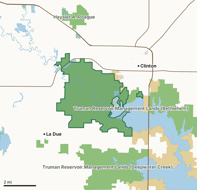
MDC conservation areasFederal land, mostly Corps of Engineers lakesNational wildlife refugesState parks and historic sitesCounty, city and regional landTruman Reservoir Management Lands (Grand River Bottoms)County lineLakeHighway
| Size | 8,505 acres in 2 pieces |
|---|---|
| County | Henry County |
| Deer harvest unit | Henry County |
| MDC lists for hunting | Deer, Turkey, Rabbit, Squirrel and Quail |
| MDC area number | 200210 |
| MDC region | Kansas City |
| Shooting range (MDC) | shotgun and rifle or pistol |
| Nearest towns | Clinton (next to it), La Due (2 mi) and Deepwater (3 mi) |
What is Truman Reservoir Management Lands (Grand River Bottoms) like?
Historically, Native Americans occupying this area were principally Osage, Shawnee and Kickapoo. Early explorers and pioneers making their way west traveled the basin, while the French trapped along the Osage River and traded with the Native Americans. Place names like Marais des Cygnes, Marmaton, Pomme de Terre, and Thibaut are vivid reminders of the early French influence in the Upper Osage Valley.
In MDC's words, from the Truman Reservoir Management Lands (Grand River Bottoms) page.
What can you hunt on Truman Reservoir Management Lands (Grand River Bottoms)?
MDC's page for Truman Reservoir Management Lands (Grand River Bottoms) lists: Deer: archery and firearms, antlerless permits allowed; Turkey: archery and firearms; Rabbit; Squirrel; Quail.
What are the rules on Truman Reservoir Management Lands (Grand River Bottoms)?
Closings: Portions of this department area are closed to protect waterfowl from October 15 through the end of the last segment of the appropriate zone's Canada goose season.
Target Shooting and Shooting Ranges: An unstaffed range is located on this department area. Target shooting is not allowed anywhere on this area except for designated shooting range(s). Shooting hours are one-half hour before sunrise to one-half hour after sunset. Ranges may be closed to public use at any time for maintenance or department sponsored events or programs. Possession of alcoholic beverages is prohibited on all ranges and associated parking lots. Groups of more than 10 people must obtain a special use permit prior to using the range. To obtain a special use permit, contact the area manager at the phone number listed...
Every conservation area also follows MDC's standard rules in Chapter 11 of the Wildlife Code; the area's full rules are on MDC's site.
How many deer are taken around Truman Reservoir Management Lands (Grand River Bottoms)?
Truman Reservoir Management Lands (Grand River Bottoms) lies in Henry County. Hunters checked 3,300 deer in Henry County in 2025, against 3,293 in 2024.
| County | Truman Reservoir Management Lands (Grand River Bottoms) acres in it | Deer, 2025 | Deer, 2024 | Deer, 2023 |
|---|---|---|---|---|
| Henry County | 8,505 | 3,300 | 3,293 | 3,754 |
Harvest for the whole county, not the conservation area alone: MDC deer harvest summaries (2021 to 2025 seasons).
How do you get to Truman Reservoir Management Lands (Grand River Bottoms)?
MDC's directions: To Grand River Bottoms: South of Clinton on Highway 13, take SW 450 west to Route T, then west to SW 351, then north. Past SW 300, Grand River Bottoms is on both sides of SW 351.
Nearest towns: Clinton (next to it), La Due (2 miles), Deepwater (3 miles) and Brownington (5 miles). Highways within 5 miles: MO 52, MO 7, MO 13 and MO 18.
What other public land is near Truman Reservoir Management Lands (Grand River Bottoms)?
MDC lands within 10 miles:
- Clinton Office: 259 acres, next to it
- Truman Reservoir Management Lands (Bethlehem): 3,402 acres, next to it
- Truman Reservoir Management Lands (Deepwater Creek): 5,637 acres, 0.7 miles away
- La Due Bottoms Conservation Area: 347 acres, 1 mile away
- Haysler A. Poague Conservation Area: 889 acres, 1.5 miles away
- Montrose Conservation Area: 2,870 acres, 3.3 miles away
Public land within 3 miles of Truman Reservoir Management Lands (Grand River Bottoms)
Counting Truman Reservoir Management Lands (Grand River Bottoms) itself, 24,382 of the 63,358 acres within 3 miles of its boundary are public land open to the public (38.5%), by USGS PAD-US 4.1 and MDC conservation area boundaries.
| Manager | Acres within 3 miles |
|---|---|
| MDC conservation areas | 16,887 |
| Federal land, mostly Corps of Engineers lakes | 7,363 |
| County, city and regional land | 82 |
| National wildlife refuges | 49 |
| State parks and historic sites | 1 |
Questions hunters ask
Where is Truman Reservoir Management Lands (Grand River Bottoms)?
In Henry County, next to Clinton.
Can you deer hunt on Truman Reservoir Management Lands (Grand River Bottoms)?
Yes, by MDC's page: archery and firearms, antlerless permits allowed.
How much public land is around Truman Reservoir Management Lands (Grand River Bottoms)?
24,382 acres within 3 miles of its boundary, Truman Reservoir Management Lands (Grand River Bottoms) included, by USGS PAD-US 4.1 and MDC conservation area boundaries. The closest other MDC area is Clinton Office (next to it).
Get a Missouri hunt plan when they open
Hunt plans for Missouri are coming. Join the list and you'll hear first. The first 50 hunters in each new state get their plan free.
Until then, the free FilledTag app for iPhone has a map that works in every state, Missouri included.
Where these facts come from
- Area description, species, rules and directions: MDC, Truman Reservoir Management Lands (Grand River Bottoms); MDC conservation area boundaries.
- Boundary and acres: MDC's map layer above. Surrounding public land: USGS PAD-US 4.1 (fee land open to the public) and MDC conservation area boundaries.
- Deer harvest: MDC deer harvest summaries (2021 to 2025 seasons).
FilledTag is not part of the Missouri Department of Conservation. Check MDC's rules and posted signs before you go.