Montrose Conservation Area: hunting and access
Montrose Conservation Area is 2,870 acres of MDC land in Henry County, 2 miles from La Due. MDC lists deer hunting here (archery only, antlerless permits allowed). Hunters checked 3,300 deer in Henry County in 2025.
Data updated October 2026. Area facts: MDC's conservation area data, read 2026-10. Harvest: MDC deer harvest summaries, 2021 to 2025.
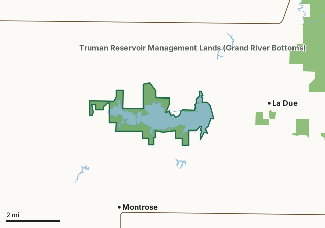
MDC conservation areasFederal land, mostly Corps of Engineers lakesMontrose Conservation AreaCounty lineLakeHighway
| Size | 2,870 acres |
|---|---|
| County | Henry County |
| Deer harvest unit | Henry County |
| MDC lists for hunting | Deer, Turkey, Rabbit, Squirrel, Dove and Quail |
| MDC area number | 5604 |
| MDC region | Kansas City |
| Camping (MDC) | individual campsites |
| Nearest towns | La Due (2 mi), Montrose (3 mi) and Hartwell (8 mi) |
What is Montrose Conservation Area like?
In the early 1950's a utility company bought nearly 4,000 acres of land along Deepwater Creek in Henry County as a site for a coal fired electrical generating plant. A 1,600 acre lake was built to provide the water necessary to cool the plant. In 1957, the company leased land to the Missouri Department of Conservation for public use. A new lease was given to the Missouri Department of Conservation in August of 2007. The current lease totals 2,750 acres and is managed for public use. Montrose Lake offers good opportunity for catfishing, birding, and waterfowl hunting.
In MDC's words, from the Montrose Conservation Area page.
What can you hunt on Montrose Conservation Area?
MDC's page for Montrose Conservation Area lists: Deer: archery only, antlerless permits allowed; Turkey: archery and firearms; Rabbit; Squirrel; Dove; Quail.
What are the rules on Montrose Conservation Area?
Closings: Portions of this department area are closed to protect waterfowl from October 15 through March 1.
Hunting: Nontoxic shot is required for all hunting with a shotgun on this area. Use or possession of lead shot is prohibited.
Waterfowl Hunting: Waterfowl may be taken only by holders of a valid area Daily Waterfowl Hunting Tag and only from a blind or in a designated area, except that hunters may retrieve dead birds and pursue and shoot downed cripples outside the designated area. Waterfowl hunters must check out immediately after the close of their hunting trip and prior to processing birds by accurate completion and return of the Daily Waterfowl Hunting Tag to designated locations. These department areas are closed to waterfowl hunting on December 25. Only authorized persons are allowed within the waterfowl shooting areas during...
Every conservation area also follows MDC's standard rules in Chapter 11 of the Wildlife Code; the area's full rules are on MDC's site.
How many deer are taken around Montrose Conservation Area?
Montrose Conservation Area lies in Henry County. Hunters checked 3,300 deer in Henry County in 2025, against 3,293 in 2024.
| County | Montrose Conservation Area acres in it | Deer, 2025 | Deer, 2024 | Deer, 2023 |
|---|---|---|---|---|
| Henry County | 2,870 | 3,300 | 3,293 | 3,754 |
Harvest for the whole county, not the conservation area alone: MDC deer harvest summaries (2021 to 2025 seasons).
How do you get to Montrose Conservation Area?
MDC's directions: From Montrose, take Highway HH north 1.50 miles, then SW 1151 (RA) north 1 mile to area headquarters.
Nearest towns: La Due (2 miles), Montrose (3 miles), Hartwell (8 miles) and Appleton City (8 miles). Highways within 5 miles: MO 18 and MO 52.
What other public land is near Montrose Conservation Area?
MDC lands within 10 miles:
- La Due Bottoms Conservation Area: 347 acres, 1.6 miles away
- Truman Reservoir Management Lands (Grand River Bottoms): 8,505 acres, 3.3 miles away
- Truman Reservoir Management Lands (Deepwater Creek): 5,637 acres, 4 miles away
- Chapel View Prairie Conservation Area: 384 acres, 6.2 miles away
- Haysler A. Poague Conservation Area: 889 acres, 7.4 miles away
- Clinton Office: 259 acres, 7.5 miles away
Public land within 3 miles of Montrose Conservation Area
Counting Montrose Conservation Area itself, 3,025 of the 44,662 acres within 3 miles of its boundary are public land open to the public (6.8%), by USGS PAD-US 4.1 and MDC conservation area boundaries.
| Manager | Acres within 3 miles |
|---|---|
| MDC conservation areas | 3,025 |
Questions hunters ask
Where is Montrose Conservation Area?
In Henry County, 2 miles from La Due.
Can you deer hunt on Montrose Conservation Area?
Yes, by MDC's page: archery only, antlerless permits allowed.
How much public land is around Montrose Conservation Area?
3,025 acres within 3 miles of its boundary, Montrose Conservation Area included, by USGS PAD-US 4.1 and MDC conservation area boundaries. The closest other MDC area is La Due Bottoms Conservation Area (1.6 miles).
Get a Missouri hunt plan when they open
Hunt plans for Missouri are coming. Join the list and you'll hear first. The first 50 hunters in each new state get their plan free.
Until then, the free FilledTag app for iPhone has a map that works in every state, Missouri included.
Where these facts come from
- Area description, species, rules and directions: MDC, Montrose Conservation Area; MDC conservation area boundaries.
- Boundary and acres: MDC's map layer above. Surrounding public land: USGS PAD-US 4.1 (fee land open to the public) and MDC conservation area boundaries.
- Deer harvest: MDC deer harvest summaries (2021 to 2025 seasons).
FilledTag is not part of the Missouri Department of Conservation. Check MDC's rules and posted signs before you go.