Harmony Mission Lake Conservation Area: hunting and access
Harmony Mission Lake Conservation Area is 1,067 acres of MDC land in Bates County, 3 miles from Rich Hill. MDC lists deer hunting here (muzzleloader and archery, antlerless permits not allowed). Hunters checked 2,316 deer in Bates County in 2025.
Data updated October 2026. Area facts: MDC's conservation area data, read 2026-10. Harvest: MDC deer harvest summaries, 2021 to 2025.
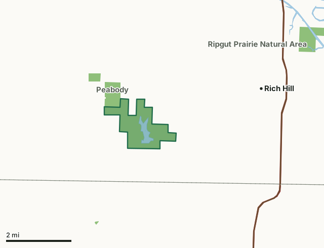
MDC conservation areasHarmony Mission Lake Conservation AreaCounty lineLakeHighway
| Size | 1,067 acres |
|---|---|
| County | Bates County |
| Deer harvest unit | Bates County |
| MDC lists for hunting | Deer, Bear, Turkey, Rabbit, Squirrel, Dove and Quail |
| MDC area number | 8206 |
| MDC region | Kansas City |
| Camping (MDC) | designated camping sites |
| Nearest towns | Rich Hill (3 mi), Metz (5 mi) and Foster (6 mi) |
What is Harmony Mission Lake Conservation Area like?
The Harmony Mission Lake Conservation Area (1,080 acres) and Peabody Conservation Area (299 acres) are managed as one area. Although separated by name, the areas adjoin and are managed primarily for early-succession, upland habitat suitable for Northern Bobwhite and other grassland nesting birds. The areas provide recreational opportunities to the public including hunting, trapping and camping. The areas also provide good fishing opportunity in a 96-acre lake and six water-filled strip-pits totaling 23 acres.
Harmony Mission, named for the first Indian mission in Missouri, was church-funded and started in 1821. The mission was located about 12 miles east of the present conservation area next to the "Great Village" of the Osage Indians on the Marais Des Cygnes River. The Osage Indians left Missouri around 1825, but remnants of the Mission can still be found. This landscape was virgin prairie until the mid 1960's, when it was sold and cleared. At that point the land was primarily farmland until 1984, when the Department bought the area from four landowners. Now, small crop fields are mixed with old fields and native grasses. The 300-acre Peabody Conservation Area was once mined for coal and was donated to the Department around 1960. Peabody lands are largely strip mine spoil mounds that have grown up in woods. Work on the area began when Conservation Department personnel, Future Farmers of...
In MDC's words, from the Harmony Mission Lake Conservation Area page.
What can you hunt on Harmony Mission Lake Conservation Area?
MDC's page for Harmony Mission Lake Conservation Area lists: Deer: muzzleloader and archery, antlerless permits not allowed; Bear: archery and firearms; Turkey: archery and firearms; Rabbit; Squirrel; Dove; Quail.
What are the rules on Harmony Mission Lake Conservation Area?
Dove Hunting: Use or possession of lead shot is prohibited for hunting doves on this area.
Every conservation area also follows MDC's standard rules in Chapter 11 of the Wildlife Code; the area's full rules are on MDC's site.
How many deer are taken around Harmony Mission Lake Conservation Area?
Harmony Mission Lake Conservation Area lies in Bates County. Hunters checked 2,316 deer in Bates County in 2025, against 2,212 in 2024.
| County | Harmony Mission Lake Conservation Area acres in it | Deer, 2025 | Deer, 2024 | Deer, 2023 |
|---|---|---|---|---|
| Bates County | 1,067 | 2,316 | 2,212 | 2,397 |
Harvest for the whole county, not the conservation area alone: MDC deer harvest summaries (2021 to 2025 seasons).
How do you get to Harmony Mission Lake Conservation Area?
MDC's directions: From Rich Hill, take Route A west 0.75 mile, then Route PP southwest 4.25 miles, then Route PP turns into gravel as Bates County Road 10508 and continues west about 1 mile to the lake entrance.
Nearest towns: Rich Hill (3 miles), Metz (5 miles), Foster (6 miles) and Hume (7 miles). Highways within 5 miles: I-49 and US 71.
What other public land is near Harmony Mission Lake Conservation Area?
MDC lands within 10 miles:
- Peabody Conservation Area: 290 acres, next to it
- Gama Grass Prairie Conservation Area: 78 acres, 3.3 miles away
- Ripgut Prairie Natural Area: 280 acres, 4.5 miles away
- August A. Busch Jr. Memorial Wetlands at Four Rivers Conservation Area: 13,960 acres, 4.6 miles away
- Old Town Access: 296 acres, 4.7 miles away
- Balltown Access: 180 acres, 5.6 miles away
Public land within 3 miles of Harmony Mission Lake Conservation Area
Counting Harmony Mission Lake Conservation Area itself, 1,361 of the 30,998 acres within 3 miles of its boundary are public land open to the public (4.4%), by USGS PAD-US 4.1 and MDC conservation area boundaries.
| Manager | Acres within 3 miles |
|---|---|
| MDC conservation areas | 1,361 |
Questions hunters ask
Where is Harmony Mission Lake Conservation Area?
In Bates County, 3 miles from Rich Hill.
Can you deer hunt on Harmony Mission Lake Conservation Area?
Yes, by MDC's page: muzzleloader and archery, antlerless permits not allowed.
How much public land is around Harmony Mission Lake Conservation Area?
1,361 acres within 3 miles of its boundary, Harmony Mission Lake Conservation Area included, by USGS PAD-US 4.1 and MDC conservation area boundaries. The closest other MDC area is Peabody Conservation Area (next to it).
Get a Missouri hunt plan when they open
Hunt plans for Missouri are coming. Join the list and you'll hear first. The first 50 hunters in each new state get their plan free.
Until then, the free FilledTag app for iPhone has a map that works in every state, Missouri included.
Where these facts come from
- Area description, species, rules and directions: MDC, Harmony Mission Lake Conservation Area; MDC conservation area boundaries.
- Boundary and acres: MDC's map layer above. Surrounding public land: USGS PAD-US 4.1 (fee land open to the public) and MDC conservation area boundaries.
- Deer harvest: MDC deer harvest summaries (2021 to 2025 seasons).
FilledTag is not part of the Missouri Department of Conservation. Check MDC's rules and posted signs before you go.