Ripgut Prairie Natural Area: hunting and access
Ripgut Prairie Natural Area is 280 acres of MDC land in Bates County, 2 miles from Rich Hill. MDC lists deer hunting here (archery and firearms, antlerless permits not allowed). Hunters checked 2,316 deer in Bates County in 2025.
Data updated October 2026. Area facts: MDC's conservation area data, read 2026-10. Harvest: MDC deer harvest summaries, 2021 to 2025.
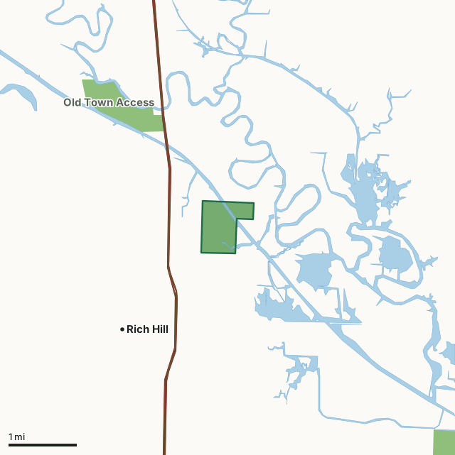
MDC conservation areasRipgut Prairie Natural AreaCounty lineLakeHighway
| Size | 280 acres |
|---|---|
| County | Bates County |
| Deer harvest unit | Bates County |
| MDC lists for hunting | Deer, Bear and Turkey |
| MDC area number | 8618 |
| MDC region | Kansas City |
| Nearest towns | Rich Hill (2 mi), Butler (10 mi) and Foster (10 mi) |
What is Ripgut Prairie Natural Area like?
Ripgut Prairie Natural Area is a 280 acre area located along the Bates Co. Drainage Ditch.
The natural area is the one of few remaining high quality examples of wet and wet-mesic prairie along the Marais des Cygnes River (Bates Co. Drainage Ditch). It is maintained by wet soil hydrology and rotational burning and haying. The area contains a diverse assemblage of wildflowers, sedges and grasses, including the namesake of the prairie, 'Ripgut' or prairie cordgrass.
In MDC's words, from the Ripgut Prairie Natural Area page.
What can you hunt on Ripgut Prairie Natural Area?
MDC's page for Ripgut Prairie Natural Area lists: Deer: archery and firearms, antlerless permits not allowed; Bear: archery and firearms; Turkey: archery and firearms.
What are the rules on Ripgut Prairie Natural Area?
MDC's standard conservation area rules (Chapter 11 of the Wildlife Code) apply; the area's rules on MDC's site list any it adds.
How many deer are taken around Ripgut Prairie Natural Area?
Ripgut Prairie Natural Area lies in Bates County. Hunters checked 2,316 deer in Bates County in 2025, against 2,212 in 2024.
| County | Ripgut Prairie Natural Area acres in it | Deer, 2025 | Deer, 2024 | Deer, 2023 |
|---|---|---|---|---|
| Bates County | 280 | 2,316 | 2,212 | 2,397 |
Harvest for the whole county, not the conservation area alone: MDC deer harvest summaries (2021 to 2025 seasons).
How do you get to Ripgut Prairie Natural Area?
MDC's directions: From Rich Hill, take Route B east 0.30 mile to Ripgut Prairie sign, then gravel road 515 north 0.50 mile, road turns east and goes 0.50 mile, then turns north and goes 0.25 mile to an unnamed gravel road that continues 0.25 mile north to the parking lot.
Nearest towns: Rich Hill (2 miles), Butler (10 miles), Foster (10 miles) and Metz (10 miles). Highways within 5 miles: I-49 and US 71.
What other public land is near Ripgut Prairie Natural Area?
MDC lands within 10 miles:
- Old Town Access: 296 acres, 1.2 miles away
- August A. Busch Jr. Memorial Wetlands at Four Rivers Conservation Area: 13,960 acres, 3.9 miles away
- Harmony Mission Lake Conservation Area: 1,067 acres, 4.5 miles away
- Peabody Conservation Area: 290 acres, 5.5 miles away
- Gama Grass Prairie Conservation Area: 78 acres, 6.5 miles away
- Balltown Access: 180 acres, 8.9 miles away
Public land within 3 miles of Ripgut Prairie Natural Area
Counting Ripgut Prairie Natural Area itself, 576 of the 23,778 acres within 3 miles of its boundary are public land open to the public (2.4%), by USGS PAD-US 4.1 and MDC conservation area boundaries.
| Manager | Acres within 3 miles |
|---|---|
| MDC conservation areas | 576 |
Questions hunters ask
Where is Ripgut Prairie Natural Area?
In Bates County, 2 miles from Rich Hill.
Can you deer hunt on Ripgut Prairie Natural Area?
Yes, by MDC's page: archery and firearms, antlerless permits not allowed.
How much public land is around Ripgut Prairie Natural Area?
576 acres within 3 miles of its boundary, Ripgut Prairie Natural Area included, by USGS PAD-US 4.1 and MDC conservation area boundaries. The closest other MDC area is Old Town Access (1.2 miles).
Get a Missouri hunt plan when they open
Hunt plans for Missouri are coming. Join the list and you'll hear first. The first 50 hunters in each new state get their plan free.
Until then, the free FilledTag app for iPhone has a map that works in every state, Missouri included.
Where these facts come from
- Area description, species, rules and directions: MDC, Ripgut Prairie Natural Area; MDC conservation area boundaries.
- Boundary and acres: MDC's map layer above. Surrounding public land: USGS PAD-US 4.1 (fee land open to the public) and MDC conservation area boundaries.
- Deer harvest: MDC deer harvest summaries (2021 to 2025 seasons).
FilledTag is not part of the Missouri Department of Conservation. Check MDC's rules and posted signs before you go.