Bates County, Missouri: deer harvest and public hunting land
Bates County covers 851 square miles around Butler. Hunters checked 2,316 deer here in the 2025 season, 1,268 of them antlered bucks, by MDC's harvest summary. That is up 5% from 2024. 1.2% of Bates County is public land open to the public, the largest share MDC conservation areas (6,481 acres), by USGS PAD-US 4.1 and MDC conservation area boundaries.
Data updated October 2026. Harvest: MDC's deer harvest summaries, 2021 to 2025. Land: PAD-US 4.1 and MDC's conservation area and MRAP layers.
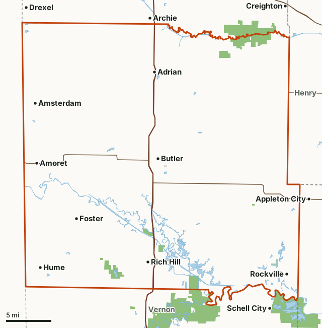
MDC conservation areasNational wildlife refugesCounty, city and regional landBates CountyNeighboring countiesLakeHighway
| Size | 544,952 acres (851 square miles) |
|---|---|
| Deer checked, 2025 | 2,316 (1,268 antlered bucks, 147 button bucks, 901 does) |
| Firearms and archery, 2025 | 1,814 by firearms, 502 by archery |
| Public land | 1.2% (6,772 acres) |
| MDC lands | 7 (6,458 acres inside Bates County) |
| MRAP land | None mapped this year |
| Towns in and near it | Butler, Adrian, Rich Hill, Archie, Appleton City and Schell City |
How many deer are harvested in Bates County?
Hunters checked 2,316 deer in Bates County in 2025: 1,268 antlered bucks, 147 button bucks and 901 does. By method: 1,814 by firearms (1,347 of them in the November portion) and 502 by archery; the rest came on managed hunts.
| Season | Deer checked | Antlered bucks | Button bucks | Does | Firearms | November portion | Archery |
|---|---|---|---|---|---|---|---|
| 2025 | 2,316 | 1,268 | 147 | 901 | 1,814 | 1,347 | 502 |
| 2024 | 2,212 | 1,152 | 148 | 912 | 1,768 | 1,369 | 444 |
| 2023 | 2,397 | 1,165 | 207 | 1,025 | 2,001 | 1,523 | 396 |
| 2022 | 2,521 | 1,372 | 192 | 957 | 2,064 | 1,736 | 456 |
| 2021 | 2,189 | 1,310 | 151 | 728 | 1,821 | 367 |
Source: MDC deer harvest summaries (2021 to 2025 seasons), Bates County, from the county tables of each season (all methods, firearms, archery and the November portion). The 2021 summary has no separate November table.
How much public land is in Bates County?
6,772 of Bates County's 544,952 acres are public land open to the public (1.2%). The biggest share is MDC conservation areas: 6,481 acres.
| Manager | Acres | Share of Bates County |
|---|---|---|
| MDC conservation areas | 6,481 | 1.2% |
| National wildlife refuges | 231 | under 0.1% |
| County, city and regional land | 58 | under 0.1% |
| State parks and historic sites | 2 | under 0.1% |
| All public land open to the public | 6,772 | 1.2% |
Measured by FilledTag inside the county line from USGS PAD-US 4.1 (fee land open to the public) and MDC conservation area boundaries. Hunting rules differ by manager: MDC conservation areas allow the hunting each area's page lists; national forest is open; Corps of Engineers lake land is open to hunting in many places under each project's own rules; refuges follow U.S. Fish and Wildlife Service rules; the Ozark National Scenic Riverways allows hunting under state rules while most other national park land is closed; state parks and city and county land are closed to most hunting.
MDC lands in Bates County
MDC lands in Bates County, largest first, with the acres of each inside it:
- Settle's Ford Conservation Area: 3,438 acres
- Harmony Mission Lake Conservation Area: 1,067 acres
- August A. Busch Jr. Memorial Wetlands at Four Rivers Conservation Area: 1,017 acres
- Old Town Access: 296 acres
- Peabody Conservation Area: 290 acres
- Ripgut Prairie Natural Area: 280 acres
- Butler City Lake: 70 acres
How do you get to Bates County?
Highways through it: US 71 (about 59 miles inside), I-49 (about 59 miles inside) and MO 52 (about 38 miles inside). Towns inside: Butler, Adrian, Rich Hill, Hume, Amsterdam and Foster. Nearby: Archie (on the line), Appleton City (on the line), Schell City (on the line) and Drexel (2 miles).
Which counties border Bates County?
Bates County touches 4 other counties. Their latest MDC harvest and public land, for comparison:
| County | Deer harvested | Year | Public land | MRAP land sites |
|---|---|---|---|---|
| Cass County | 2,731 | 2025 | 1.6% | |
| Henry County | 3,300 | 2025 | 14.2% | |
| Vernon County | 3,131 | 2025 | 5% | 2 |
| St. Clair County | 3,383 | 2025 | 11.8% |
Questions hunters ask
How many deer were harvested in Bates County in 2025?
Hunters checked 2,316 deer: 1,268 antlered bucks, 147 button bucks and 901 does (MDC). In 2024: 2,212.
Is there public hunting land in Bates County?
Yes. 6,772 acres, 1.2% of the county, are public land open to the public by USGS PAD-US 4.1 and MDC conservation area boundaries, the largest share MDC conservation areas (6,481 acres). MDC's map shows 7 conservation areas here.
Does Bates County have MRAP land?
Not on MDC's MRAP layer of tracts open to hunting.
Get a Missouri hunt plan when they open
Hunt plans for Missouri are coming. Join the list and you'll hear first. The first 50 hunters in each new state get their plan free.
Until then, the free FilledTag app for iPhone has a map that works in every state, Missouri included.
Where these numbers come from
- Deer harvest: MDC deer harvest summaries (2021 to 2025 seasons).
- Public land: USGS PAD-US 4.1 (fee land open to the public) and MDC conservation area boundaries. conservation areas: MDC conservation area boundaries. MRAP land: MDC Missouri Recreational Access Program (MRAP) lands.
- Boundaries: U.S. Census Bureau 2024 cartographic county boundaries. Highways and towns: U.S. Census Bureau TIGER/Line 2024 primary and secondary roads; U.S. Census Bureau 2024 Gazetteer, places.
FilledTag is not part of the Missouri Department of Conservation. Numbers are copied from MDC and the federal sources above, or measured from their maps; nothing on this page is estimated by FilledTag.
Missouri hunting Cass County Henry County Vernon County St. Clair County