Nevada mountain goat hunting in unit 101
Unit 101 is a single unit in Elko County: 279,562 acres, 32.1% public land, mostly national forest (63,446 acres), measured from BLM's surface management map. In 2025, NDOW issued 2 mountain goat tags here across 1 hunt; 2 hunters went afield and 2 were successful (100% of those who hunted, worked out from NDOW's two figures). NDOW's draw rate for the resident any-legal-weapon hunt was 0.1%: 2 tags for a demand of 2,208.
Data updated October 2026. Tags and harvest: NDOW hunt statistics, 2022 to 2025. Seasons: NDOW's 2026-2027 regulation with its January 2026 amendment. Land: BLM.
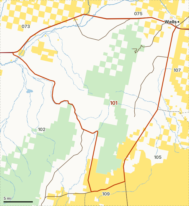
BLMNational forestTribal landUnit 101Neighboring unitsLake or riverHighway
| Units | 101 |
|---|---|
| County | Elko |
| NDOW region | Eastern Region |
| Size | 279,562 acres (437 square miles) |
| Public land | 32.1% (89,613 acres) |
| Mountain goat tags, 2025 | 2 issued, quota 2 |
| Successful hunters, 2025 | 2 of 2 afield |
| Resident any-legal-weapon draw rate, 2025 (NDOW) | 0.1% (2 tags, demand 2,208) |
| Resident mountain goat season, any legal weapon, 2026 | September 1 to October 31 |
| Towns in and near it | Wells and Elko |
How many mountain goat tags does NDOW issue in unit 101?
NDOW issued 2 mountain goat tags for unit 101 in 2025, against a quota of 2. Every 2025 hunt in the group, as NDOW reports it:
| Hunt | Residency | Weapon | Season | Quota | Tags issued | Demand | NDOW draw rate | Hunters afield | Successful | Hunter success |
|---|---|---|---|---|---|---|---|---|---|---|
| Mountain Goat Either Sex | Resident | Any legal weapon | Sep 1 - Oct 31 | 2 | 2 | 2,208 | 0.1% | 2 | 2 | 100% |
Source: NDOW Big Game Hunt Statistics (2022 to 2025; 2025 from NDOW's 2025 hunt data workbook). Demand is NDOW's count of tags awarded plus unsuccessful first-choice applicants. NDOW's draw rate is its quota divided by that demand; NDOW says it does not account for bonus points. Hunter success is successful hunters out of hunters afield.
What is hunter success for mountain goat in unit 101?
2 of 2 hunters afield were successful in 2025, 100% across the group's hunts. The group year by year:
| Year | Hunts | Quota | Tags issued | Hunters afield | Successful hunters | Success, all hunts | Labels NDOW used for the group |
|---|---|---|---|---|---|---|---|
| 2025 | 1 | 2 | 2 | 2 | 2 | 100% | 101 |
| 2024 | 1 | 1 | 1 | 1 | 1 | 100% | 101 |
| 2023 | 1 | 1 | 1 | 1 | 1 | 100% | 101 |
| 2022 | 1 | 1 | 1 | 1 | 1 | 100% | 101 |
Source: NDOW Big Game Hunt Statistics (2022 to 2025; 2025 from NDOW's 2025 hunt data workbook). Totals are NDOW's hunt rows added together; the success share is worked out from NDOW's own two figures. A year is shown only where NDOW published the group's hunts; NDOW sometimes splits a unit with a letter (108B, 144A) or a portion, and those labels are listed.
When is mountain goat season in unit 101 in 2026?
The 2026-2027 seasons NDOW's regulation sets for this unit group:
| Hunt number | Hunt | Weapon | Unit group as NDOW prints it | 2026-2027 season | 2025-2026 season |
|---|---|---|---|---|---|
| 7151 | Resident Mountain Goat - Any Goat | Any Legal Weapon | 101 | Sep 1 - Oct 31 | Sep 1 - Oct 31 |
Source: NDOW Commission Regulation 25-07, 2026-2027 big game seasons, with Amendment #2 (January 2026). * Changed or added by Amendment #2. NDOW can change a season during the year; check NDOW before you go.
How much public land is in unit 101?
32.1% of unit 101 is public land open to hunting under its manager's rules: 89,613 of 279,562 acres. The largest share is national forest, 63,446 acres or 22.7%.
| Manager | Acres | Share |
|---|---|---|
| National forest | 63,446 | 22.7% |
| BLM | 26,167 | 9.4% |
Measured by FilledTag inside NDOW's unit boundaries from BLM Surface Management Agency map (national, limited scale), a generalized national map; the rest is private or not mapped. Military, Energy Department and tribal land are not counted as open to hunting (they are closed to the public or need the owner's permission).
Other species NDOW groups with unit 101: Pronghorn antelope (101 - 104, 108 - 109, 144), Mule deer (101 - 109), Moose (061, 062, 064, 066 - 068, 071 - 077, 081, 101 - 103).
How do you get to unit 101?
Highways through it: NV 232 (about 13 miles inside), NV 230 (about 12 miles inside) and NV 231 (about 10 miles inside). Along its boundary: I-80, US 93 and NV 229. Nearby: Wells (on the line) and Elko (18 miles).
Which units border unit 101?
7 hunt units touch unit 101. Their public land and their own mountain goat group:
| Unit | Public land | Mountain goat page | County |
|---|---|---|---|
| Unit 073 | 71.5% | No mountain goat group page | Elko |
| Unit 075 | 58.8% | No mountain goat group page | Elko |
| Unit 077 | 53.8% | No mountain goat group page | Elko |
| Unit 102 | 52.4% | 102 | Elko |
| Unit 105 | 88.8% | No mountain goat group page | Elko |
| Unit 107 | 47.3% | No mountain goat group page | Elko |
| Unit 109 | 98.9% | No mountain goat group page | Elko |
Questions hunters ask
How many mountain goat tags are there in unit 101?
NDOW set a quota of 2 mountain goat tags for unit 101 in 2025 and issued 2, across 1 hunt by residency, weapon and season. In 2024 it issued 1.
What is hunter success for mountain goat in unit 101?
In 2025, 2 of the 2 hunters NDOW counted afield took a mountain goat here, 100% across every hunt in the group.
How hard is it to draw a mountain goat tag in unit 101?
NDOW's draw rate for the 2025 resident any-legal-weapon hunt here was 0.1%: a quota of 2 against a demand of 2,208. NDOW describes the draw rate as quota divided by demand; it does not account for bonus points.
When is mountain goat season in unit 101 in 2026?
For mountain goats of either sex, NDOW's 2026-2027 regulation sets: resident any legal weapon, September 1 to October 31.
How much public land is in unit 101?
32.1% of the 279,562 acres, measured from BLM's surface management map; the largest share is national forest, 63,446 acres.
What is the closest town to unit 101?
No town is inside it. The nearest are Wells (on the line) and Elko (18 miles).
Get a Nevada hunt plan when they open
Hunt plans for Nevada are coming. Join the list and you'll hear first. The first 50 hunters in each new state get their plan free.
Until then, the free FilledTag app for iPhone has a map that works in every state, Nevada included.
Where these numbers come from
- Tags, quota, demand, draw rate, hunters and success: NDOW Big Game Hunt Statistics (2022 to 2025; 2025 from NDOW's 2025 hunt data workbook).
- Seasons: NDOW Commission Regulation 25-07, 2026-2027 big game seasons, with Amendment #2 (January 2026).
- Public land: BLM Surface Management Agency map (national, limited scale). Unit boundaries: NDOW hunt units.
- Highways and towns: U.S. Census Bureau TIGER/Line 2024 primary and secondary roads; U.S. Census Bureau 2024 Gazetteer, places.
FilledTag is not part of the Nevada Department of Wildlife. Numbers are copied from NDOW or measured from public maps; nothing on this page is estimated by FilledTag.