Overton Wildlife Management Area: hunting rules and map
Overton Wildlife Management Area is 17,665 acres in Clark County, managed by NDOW in its Southern Region and inside hunt units 267 and 272. NDOW lists hunting on the area, with this rule first: some hunt days are by reservation through NDOW's Overton/Key Pittman reservation system.
Data updated October 2026. Area rules: NDOW's public land page, read 2026-10-18. Boundary and acres: NDOW GIS. Land around it: BLM.
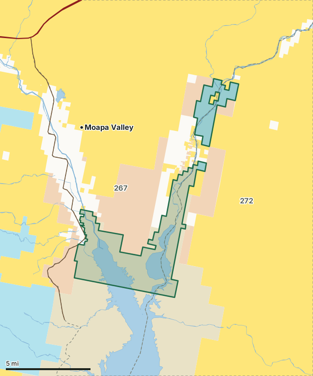
BLMState landBureau of ReclamationNational Park ServiceOverton WMAHunt unit lineLake or riverHighway
| Size | 17,665 acres (NDOW legal acres) |
|---|---|
| County | Clark County |
| NDOW region | Southern Region |
| Hunt units | 267, 272 |
| Status in NDOW's map | Designated; MOU on lands leased from NPS and BOR |
| Camping | Permitted in those sites designated for camping |
| Nearest towns | Moapa Valley (5 mi), Bunkerville (11 mi) and Mesquite (14 mi) |
What is Overton WMA?
Overton Wildlife Management Area (OWMA) lies in the lower extremes of the Moapa and Virgin river valleys where they flow into the north end of the Overton Arm of Lake Mead. This is about 65 miles northeast of Las Vegas using Interstate 15 and State Route 169.
In NDOW's words, from NDOW's public land page.
What are the rules on Overton WMA?
| Topic | NDOW's rule |
|---|---|
| Hunting | Some hunt days are by reservation through NDOW's Overton/Key Pittman reservation system. During the waterfowl season, hunting is permitted on the Moapa Valley portion of the area only on the opening day of the duck season, even numbered days thereafter throughout the season, opening day of the goose season, and the closing two days of the duck and goose seasons. Before or after the waterfowl season, hunting is allowed every day for wildlife species upon which there is an established open season. During the opening day and the first weekend of the dove season the maximum capacity for the Moapa Valley portion of the area is 60 hunters by reservation only. During the waterfowl season on the Moapa Valley portion of the area, hunters must hunt from assigned hunt locations (blinds) constructed by the Department of Wildlife. A maximum of up to four hunters are permitted at each hunt location. Assigned hunt locations are marked by numbered stakes. Hunters shall hunt only within their assigned hunt location and moving to vacant locations is prohibited. The only exception involves reasonable accommodation of the disabled. The hunting of upland game species is prohibited during the waterfowl season. On Overton Hunt days, only persons authorized to hunt waterfowl may use vessels on the portion of the area inundated by Lake Mead. |
| Camping | Permitted in those sites designated for camping |
| Campfires | Permitted in those sites designated for camping |
| Trespass and travel | Trespass prohibited from March 1 through Aug. 1 on Honeybee Pond and Center Pond |
| Boats | Vessels are prohibited on all ponds. Vessels are allowed on the portion of the area inundated by Lake Mead, except that on Overton Hunt Days, vessels may be used only by persons authorized to hunt waterfowl |
| Bodies of water | Lake Mead, Honeybee Pond, Center Pond, Numerous other seasonally flooded ponds |
Source: NDOW, Your Public Land. Big game seasons on the area follow the hunt unit's regulations.
Which big game unit groups take in Overton WMA?
NDOW draws big game tags by unit group. The groups that include units 267 and 272, with NDOW's 2025 figures for the whole group, not the WMA alone:
| Species and group | Tags issued, 2025 | Successful hunters, 2025 |
|---|---|---|
| Mule deer, 261 - 268 | 69 | 26 |
| Mule deer, 271, 272 | 38 | 13 |
| Desert bighorn sheep, 267 | 10 | 10 |
| Desert bighorn sheep, 272 | 1 | 0 |
Source: NDOW Big Game Hunt Statistics (2022 to 2025; 2025 from NDOW's 2025 hunt data workbook).
What land surrounds Overton WMA?
Inside the WMA boundary, BLM's surface management map shows National Park Service 14,153 acres, state land 3,038 acres and BLM 20 acres. NDOW's WMA map records its status as designated (MOU on lands leased from NPS and BOR). Highways within 8 miles: NV 169, I-15 and NV 170. Nearest towns: Moapa Valley (5 miles), Bunkerville (11 miles), Mesquite (14 miles) and Moapa Town (16 miles).
Questions hunters ask
Can you hunt on Overton WMA?
Yes. NDOW's rule for hunting on the area: Some hunt days are by reservation through NDOW's Overton/Key Pittman reservation system. During the waterfowl season, hunting is permitted on the Moapa Valley portion of the area only on the opening day of the duck season, even numbered days thereafter throughout the season, opening day of the goose season, and the closing two days of the duck and goose seasons. Before or after the waterfowl season, hunting is allowed every day for wildlife species upon which there is an established open season. During the opening day and the first weekend of the dove season the maximum capacity for the Moapa Valley portion of the area is 60 hunters by reservation only. During the waterfowl season on the Moapa Valley portion of the area, hunters must hunt from assigned hunt locations (blinds) constructed by the Department of Wildlife. A maximum of up to four hunters are permitted at each hunt location. Assigned hunt locations are marked by numbered stakes. Hunters shall hunt only within their assigned hunt location and moving to vacant locations is prohibited. The only exception involves reasonable accommodation of the disabled. The hunting of upland game species is prohibited during the waterfowl season. On Overton Hunt days, only persons authorized to hunt waterfowl may use vessels on the portion of the area inundated by Lake Mead.
Can you camp on Overton WMA?
NDOW lists camping as: Permitted in those sites designated for camping
Which hunt unit is Overton WMA in?
By NDOW's boundaries: unit 267 (12,381 acres) and unit 272 (4,846 acres).
Where is Overton WMA?
Overton Wildlife Management Area (OWMA) lies in the lower extremes of the Moapa and Virgin river valleys where they flow into the north end of the Overton Arm of Lake Mead. The nearest town by the census map is Moapa Valley, 5 miles away.
Get a Nevada hunt plan when they open
Hunt plans for Nevada are coming. Join the list and you'll hear first. The first 50 hunters in each new state get their plan free.
Until then, the free FilledTag app for iPhone has a map that works in every state, Nevada included.
Where these facts come from
- Description and rules: NDOW, Your Public Land.
- Boundary, acres and status: NDOW wildlife management areas. Surrounding land: BLM Surface Management Agency map (national, limited scale).
- Unit group figures: NDOW Big Game Hunt Statistics (2022 to 2025; 2025 from NDOW's 2025 hunt data workbook).
FilledTag is not part of the Nevada Department of Wildlife.
Nevada hunting Southern Region Mule deer 261 - 268 Mule deer 271, 272 Desert bighorn sheep 267 Desert bighorn sheep 272