Colockum Wildlife Area: hunting, units and access
The Colockum Wildlife Area is 88,282 acres of land managed by WDFW in Region 3, inside GMUs 329, 251, 328 and 330, measured from WDFW's boundary. The busiest elk unit it touches is GMU 329, where WDFW reports 140 elk taken in 2025.
Data updated October 2026. Area facts: WDFW's page for the Colockum Wildlife Area, read 2026-10-18, and WDFW's facility data. Harvest: WDFW reports to 2025.
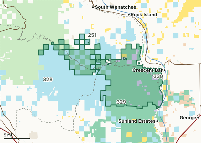
National forestBLMDNR state trust landWDFW landNational wildlife refuge (refuge rules; not counted)Bureau of ReclamationOther public (parks, county, city, other agencies)Colockum Wildlife AreaGMU lineLake or riverHighway
| Size | 88,282 acres (WDFW boundary, measured by FilledTag); WDFW's page says 88,296 acres |
|---|---|
| WDFW region | Region 3, South Central Washington |
| GMUs | GMU 329, GMU 251, GMU 328, GMU 330 |
| Roads and trails | 237 miles, 200 of them Green Dot roads |
| Parking areas | 5 |
| Boat ramps | 1 |
| Nearest towns | Rock Island (6 mi), East Wenatchee (7 mi) and George (7 mi) |
What is the Colockum Wildlife Area like?
The Colockum Wildlife Area features exceptionally diverse fish and wildlife habitat that includes shrubsteppe, conifer forest, high elevation lakes, and perennial and seasonal streams. Every year, thousands enjoy hunting, fishing, camping, and wildlife viewing here. Wildlife use is diverse, and resident and migratory fish include chinook, sockeye and coho salmon, steelhead, smallmouth bass, perch, trout, walleye, and white sturgeon in the Columbia River and its tributaries.
The Colockum Wildlife Area is located approximately 15 miles south of Wenatchee, and 20 miles northeast of Ellensburg in Kittitas and Chelan counties. The unit can be accessed from the north on Tarpiscan and Colockum roads off of the Malaga/Alcoa Highway. It can be accessed from the south from the Old Vantage Highway and the Colockum Pass Road.
In WDFW's words, from WDFW's Colockum Wildlife Area page.
What are WDFW's hunting rules on the Colockum Wildlife Area?
WDFW's hunting notes for the area, in its words:
- Not all Game Management Units are open to all general elk and deer seasons. For specific hunt information, seasons and bag limits consult the current Washington Big Game Hunting Seasons and Regulations pamphlet, and the current Washington State Migratory Waterfowl and Upland Game Seasons pamphlet.
- A Game Reserve is established on this unit (WAC 220-411-010). Game Reserves are CLOSED AREAS where hunting and trapping for all wild animals and wild birds is prohibited (RCW 77.12.047).
- A small SAFETY ZONE exists around the Colockum Headquarters; it is unlawful to hunt inside this zone.
- A special migratory bird closure exists on this unit. It is unlawful to hunt migratory waterfowl, coot, and snipe within this area (WAC 220-416-070).
- Snowmobiling is prohibited on big game winter range (east of the Colockum Road, Brewton Road, Powerline Road and Colockum Pass Road).
From WDFW's Colockum Wildlife Area page. Seasons and legal animals follow the GMU the ground is in.
How many elk and deer are taken in the GMUs around the Colockum Wildlife Area?
WDFW reports harvest by GMU, not by wildlife area. These are the whole GMUs the area lies in:
| GMU | Wildlife area acres in it | Elk taken, 2025 | Deer taken, 2025 | Bears taken, 2025 |
|---|---|---|---|---|
| GMU 329 Quilomene | 50,637 | 140 | 11 | 7 |
| GMU 251 Mission | 25,490 | 59 | 159 | 19 |
| GMU 328 Naneum | 8,517 | 138 | 105 | 7 |
| GMU 330 West Bar | 3,638 | 4 | 6 | 0 |
Harvest: WDFW Game Harvest Reports (GMU, 2025). Wildlife area acres in each GMU measured by FilledTag from WDFW's boundaries.
How do you get to the Colockum Wildlife Area?
Highways within 5 miles: SR 28. Nearest towns: Rock Island (6 miles), East Wenatchee (7 miles), George (7 miles) and Quincy (8 miles).
WDFW's access notes:
- Motorized vehicles are ONLY allowed on Green Dot roads and county roads. Parking is allowed within 100 feet of these roads.
- All Colockum roads are extremely primitive. High clearance, four-wheel drive vehicles are recommended. Visitors should carry water, supplies and a spare tire. Tarpiscan Road is impassable to motor vehicles south of the wildlife area headquarters due to several large washouts. Colockum Road may be impassable by wheeled vehicles Dec. through March.
- The Arthur Coffin Game Reserve is closed to public entry, except from Dec. 1 through Feb. 28 for winter recreation.
- Snowmobiling is prohibited on big game winter range (east of the Colockum Road, Brewton Road, Powerline Road and Colockum Road).
- Parking and restroom at Yoyo Rock water access site
Questions hunters ask
Do you need a pass to park at the Colockum Wildlife Area?
Yes. Parking on WDFW land needs the Vehicle Access Pass that comes with most annual hunting and fishing licenses, or a Discover Pass, displayed where it can be seen from outside the vehicle (WDFW pamphlet, page 72).
Which GMUs is the Colockum Wildlife Area in?
GMU 329 Quilomene (50,637 acres), GMU 251 Mission (25,490 acres), GMU 328 Naneum (8,517 acres) and GMU 330 West Bar (3,638 acres), by WDFW's boundaries. Seasons follow each GMU's rules.
Can you camp on the Colockum Wildlife Area?
WDFW's facility data lists no developed campground on the Colockum Wildlife Area. Camping on WDFW land follows WDFW's public conduct rules and any closures posted for the area; check WDFW's page before planning a camp.
Can you drive on the Colockum Wildlife Area?
On marked roads. WDFW's data counts 200 miles of Green Dot roads here, the roads open to motor vehicles under WDFW's Green Dot system, out of 237 miles of roads and trails.
Get a Washington hunt plan when they open
Hunt plans for Washington are coming. Join the list and you'll hear first. The first 50 hunters in each new state get their plan free.
Until then, the free FilledTag app for iPhone has a map that works in every state, Washington included.
Where these facts come from
- Area description, rules and access notes: WDFW, Colockum Wildlife Area.
- Boundary, units and facilities: WDFW wildlife area and unit boundaries. Surrounding public land: WA DNR Major Public Lands (non-DNR) and WA DNR Managed Land Parcels, read 2026-10.
- GMU harvest: WDFW Game Harvest Reports. Parking passes: WDFW 2026 Big Game Hunting Seasons and Regulations, page 72.
FilledTag is not part of Washington Department of Fish and Wildlife. Numbers are copied from WDFW and the State of Washington, or measured from their maps; nothing on this page is estimated by FilledTag. WDFW's regulations are the final word on every rule.
Washington hunting Region 3 GMU 329 elk GMU 251 elk GMU 328 elk GMU 330 elk