Columbia Basin Wildlife Area: hunting, units and access
The Columbia Basin Wildlife Area is 170,840 acres of land managed by WDFW in Region 2, in 14 units, inside GMUs 290, 272, 278, 248, 284 and 254, measured from WDFW's boundary. The busiest elk unit it touches is GMU 272, where WDFW reports 26 elk taken in 2025.
Data updated October 2026. Area facts: WDFW's page for the Columbia Basin Wildlife Area, read 2026-10-18, and WDFW's facility data. Harvest: WDFW reports to 2025.
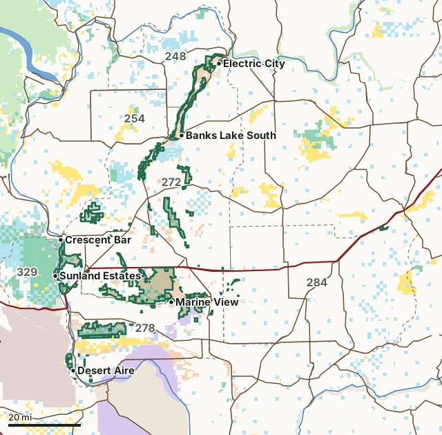
National forestBLMDNR state trust landWDFW landNational wildlife refuge (refuge rules; not counted)Bureau of ReclamationNational recreation areaMilitary land (restricted)Other public (parks, county, city, other agencies)Columbia Basin Wildlife AreaGMU lineLake or riverHighway
| Size | 170,840 acres (WDFW boundary, measured by FilledTag) |
|---|---|
| WDFW region | Region 2, North Central Washington |
| GMUs | GMU 290, GMU 272, GMU 278, GMU 248, GMU 284, GMU 254 |
| Units | 14 |
| Roads and trails | 397 miles |
| Parking areas | 151 |
| Campgrounds | 1 |
| Boat ramps | 42 |
| Nearest towns | Coulee City (next to it), Grand Coulee (next to it) and George (next to it) |
What is the Columbia Basin Wildlife Area like?
The Columbia Basin Wildlife Area is located in Grant County and Adams County, and includes approximately 160,100 acres thoughout units spanning the "Big Bend" of the Columbia River. Although managed by WDFW, most of these lands are owned by the U.S. Bureau of Reclamation (BOR) or other federal and state agencies. Many of the wildlife area's units were acquired as mitigation for habitat inundation caused by Columbia River dams. These units provide habitat for numerous wetland dependent wildlife species, such as migrating waterfowl and shorebirds, as well as upland game birds. Northern leopard frogs, sagebrush lizards, Columbia River tiger beetles, burrowing owls, golden eagles, loggerhead shrikes, sage sparrows, sage thrashers, western grebes, black-tailed jack rabbits, striped whipsnakes, and Washington ground squirrels can be found on most of the units. By actively managing lands, restoring habitats, and preserving wild places, the department serves as stewards for Washington's natural places, protecting the state's land and water for its human and wildlife populations.
In WDFW's words, from WDFW's Columbia Basin Wildlife Area page.
What units make up the Columbia Basin Wildlife Area?
WDFW manages the area as 14 units. The largest is Desert at 62,470 acres.
| Unit | Acres | GMUs | Parking areas | Campgrounds | Hunting blinds |
|---|---|---|---|---|---|
| Desert | 62,470 | 278, 290 | 41 | 0 | 0 |
| Lower Crab Creek | 24,813 | 278 | 9 | 0 | 0 |
| Quincy Lakes | 17,725 | 272, 278, 290, 329 | 37 | 0 | 0 |
| Banks Lake | 17,303 | 248, 254, 272 | 10 | 1 | 0 |
| Gloyd Seeps | 11,341 | 272 | 16 | 0 | 0 |
| Beezley Hills | 9,358 | 272 | 0 | 0 | 0 |
| Seep Lakes | 8,806 | 278 | 13 | 0 | 0 |
| Sun Lakes | 6,503 | 272 | 8 | 0 | 0 |
| Billy Clapp Lake | 4,572 | 272 | 3 | 0 | 0 |
| Priest Rapids | 2,739 | 278 | 2 | 0 | 0 |
| Winchester Reservoir | 1,567 | 272 | 3 | 0 | 0 |
| Rocky Ford | 1,494 | 272 | 4 | 0 | 0 |
| Upland Restoration | 1,437 | 272, 278, 284, 290 | 0 | 0 | 0 |
| Sprague Lake | 711 | 284 | 5 | 0 | 0 |
Unit outlines and facilities: WDFW wildlife area and unit boundaries. Acres measured by FilledTag.
WDFW's notes for each unit
Lower Crab Creek: WDFW releases pheasants on this unit to provide a hunting opportunity. WDFW
Quincy Lakes: A special migratory bird closure exists on the Columbia River adjacent to this unit (see section (5) of WAC 220-416-070). It is unlawful to hunt migratory waterfowl, coot, and snipe within this area. WDFW
Banks Lake: Game Reserves are CLOSED AREAS where hunting and trapping for all wild animals and wild birds is prohibited (RCW 77.12.047). WDFW
Gloyd Seeps: WDFW releases pheasants on this unit to provide hunting opportunity. WDFW
Beezley Hills: Though cottontail rabbits are open to hunting on this unit, hunters are encouraged not to hunt rabbits in this area due to the similarity in appearance to the federally endangered Columbia Basin pygmy rabbit. WDFW
Seep Lakes: Species of primary hunting focus on this unit are black-tailed deer and turkey. WDFW
Billy Clapp Lake: A Game Reserve is established on this unit (WAC 220-411-210). Game Reserves are CLOSED AREAS where hunting and trapping for all wild animals and wild birds is prohibited (RCW 77.12.047). WDFW
Priest Rapids: WDFW releases pheasants on this unit to provide a hunting opportunity. WDFW
How many elk and deer are taken in the GMUs around the Columbia Basin Wildlife Area?
WDFW reports harvest by GMU, not by wildlife area. These are the whole GMUs the area lies in:
| GMU | Wildlife area acres in it | Elk taken, 2025 | Deer taken, 2025 | Bears taken, 2025 |
|---|---|---|---|---|
| GMU 290 Desert | 62,417 | 2 | 42 | 0 |
| GMU 272 Beezley | 61,680 | 26 | 337 | 0 |
| GMU 278 Wahluke | 37,490 | 2 | 95 | 0 |
| GMU 248 Big Bend | 6,493 | 0 | 126 | 9 |
| GMU 284 Ritzville | 1,397 | 15 | 506 | 0 |
| GMU 254 Saint Andrews | 1,347 | 0 | 80 | 0 |
Harvest: WDFW Game Harvest Reports (GMU, 2025). Wildlife area acres in each GMU measured by FilledTag from WDFW's boundaries.
How do you get to the Columbia Basin Wildlife Area?
Highways within 5 miles: I-90, SR 17, SR 28, SR 26 and SR 155. Nearest towns: Coulee City (next to it), Grand Coulee (next to it), George (next to it) and Mattawa (next to it).
Questions hunters ask
Do you need a pass to park at the Columbia Basin Wildlife Area?
Yes. Parking on WDFW land needs the Vehicle Access Pass that comes with most annual hunting and fishing licenses, or a Discover Pass, displayed where it can be seen from outside the vehicle (WDFW pamphlet, page 72).
Which GMUs is the Columbia Basin Wildlife Area in?
GMU 290 Desert (62,417 acres), GMU 272 Beezley (61,680 acres), GMU 278 Wahluke (37,490 acres), GMU 248 Big Bend (6,493 acres), GMU 284 Ritzville (1,397 acres) and GMU 254 Saint Andrews (1,347 acres), by WDFW's boundaries. Seasons follow each GMU's rules.
Can you camp on the Columbia Basin Wildlife Area?
WDFW's facility data lists 1 campground on the Columbia Basin Wildlife Area. Follow the posted rules and WDFW's public conduct rules.
Get a Washington hunt plan when they open
Hunt plans for Washington are coming. Join the list and you'll hear first. The first 50 hunters in each new state get their plan free.
Until then, the free FilledTag app for iPhone has a map that works in every state, Washington included.
Where these facts come from
- Area description, rules and access notes: WDFW, Columbia Basin Wildlife Area.
- Boundary, units and facilities: WDFW wildlife area and unit boundaries. Surrounding public land: WA DNR Major Public Lands (non-DNR) and WA DNR Managed Land Parcels, read 2026-10.
- GMU harvest: WDFW Game Harvest Reports. Parking passes: WDFW 2026 Big Game Hunting Seasons and Regulations, page 72.
FilledTag is not part of Washington Department of Fish and Wildlife. Numbers are copied from WDFW and the State of Washington, or measured from their maps; nothing on this page is estimated by FilledTag. WDFW's regulations are the final word on every rule.
Washington hunting Region 2 GMU 272 elk GMU 278 elk GMU 284 elk