Mount Saint Helens Wildlife Area: hunting, units and access
The Mount Saint Helens Wildlife Area is 10,177 acres of land managed by WDFW in Region 5, in 16 units, inside GMUs 522, 556, 560, 524, 504, 564, 530, 520, 550, 506, 681 and 568, measured from WDFW's boundary. The busiest elk unit it touches is GMU 560, where WDFW reports 73 elk taken in 2025.
Data updated October 2026. Area facts: WDFW's page for the Mount Saint Helens Wildlife Area, read 2026-10-18, and WDFW's facility data. Harvest: WDFW reports to 2025.
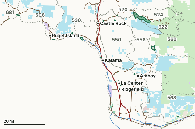
National forestDNR state trust landWDFW landNational wildlife refuge (refuge rules; not counted)Military land (restricted)Other public (parks, county, city, other agencies)Mount Saint Helens Wildlife AreaGMU lineLake or riverHighway
| Size | 10,177 acres (WDFW boundary, measured by FilledTag) |
|---|---|
| WDFW region | Region 5, Southwest Washington |
| GMUs | GMU 522, GMU 556, GMU 560, GMU 524, GMU 504, GMU 564, GMU 530, GMU 520, GMU 550, GMU 506, GMU 681, GMU 568 |
| Units | 16 |
| Roads and trails | 36 miles |
| Parking areas | 10 |
| Boat ramps | 3 |
| Nearest towns | La Center (next to it), Kalama (next to it) and Ridgefield (2 mi) |
What is the Mount Saint Helens Wildlife Area like?
The Mount St. Helens Wildlife Area is comprised of units that span Skamania, Clark, Cowlitz, and Wahkiakum counties, and totals approximately 10,500 acres of land. Habitat include tidal mudflats, wetlands, riparian, old-growth forest,forested floodplains, early seral mixed forest, ancient lava flows and volcanic deposits, and open grasslands. The units receive the most attention from a wildlife management perspective and provide some of the most critical winter range habitat for a portion of the Mount St. Helens Elk Herd. Many of the units support salmonid rearing and spawning habitat for threatened or endangered fish species.
In WDFW's words, from WDFW's Mount Saint Helens Wildlife Area page.
What units make up the Mount Saint Helens Wildlife Area?
WDFW manages the area as 16 units. The largest is Hoffstadt at 3,913 acres.
| Unit | Acres | GMUs | Parking areas | Campgrounds | Hunting blinds |
|---|---|---|---|---|---|
| Hoffstadt | 3,913 | 520, 522, 524, 556 | 0 | 0 | 0 |
| Mudflow | 2,861 | 522, 524 | 0 | 0 | 0 |
| Merrill Lake | 1,448 | 560 | 1 | 0 | 0 |
| Fisher Island | 920 | 504 | 0 | 0 | 0 |
| Altoona | 193 | 506, 681 | 1 | 0 | 0 |
| Abernathy Creek | 132 | 530 | 1 | 0 | 0 |
| Cedar Creek | 121 | 564 | 1 | 0 | 0 |
| Canal Road | 117 | 550 | 0 | 0 | 0 |
| White Island | 117 | 530 | 0 | 0 | 0 |
| Nelson | 103 | 564 | 2 | 0 | 0 |
| Nellie Corser | 61 | 568 | 1 | 0 | 0 |
| Gardner | 58 | 520 | 0 | 0 | 0 |
| Two Forks | 40 | 564 | 1 | 0 | 0 |
| Duck Lake (Clark County) | 38 | 564 | 0 | 0 | 0 |
| Carnine | 37 | 550 | 0 | 0 | 0 |
| Jenny Creek | 20 | 564 | 1 | 0 | 0 |
Unit outlines and facilities: WDFW wildlife area and unit boundaries. Acres measured by FilledTag.
WDFW's notes for each unit
Hoffstadt: The Toutle GMU 556 portion of this unit is open to elk hunting by special permit only. WDFW
Mudflow: This unit is in Game Management Unit 522 (Loo-wit) which is designated as a CLOSED AREA to the hunting of all wild animals and wild birds except by special permit. WDFW
Merrill Lake: This unit may provide hunting opportunities for band-tailed pigeon, black bear, black-tailed deer, cougar, waterfowl, elk, grouse, and small game. WDFW
Fisher Island: Columbian white-tailed deer are present in the area and are illegal to hunt. WDFW
Altoona: This unit may provide hunting opportunities for deer, waterfowl, elk, and small game. WDFW
Abernathy Creek: This unit may provide hunting opportunities for deer, waterfowl, elk, and small game. WDFW
Cedar Creek: This unit is in a restricted firearm use zone, in which only shotguns and bow and arrow equipment can be used. The use of rifles and pistols here is prohibited under county rules. WDFW
Canal Road: This unit may provide hunting opportunities for deer, waterfowl, elk, and small game. WDFW
How many elk and deer are taken in the GMUs around the Mount Saint Helens Wildlife Area?
WDFW reports harvest by GMU, not by wildlife area. These are the whole GMUs the area lies in:
| GMU | Wildlife area acres in it | Elk taken, 2025 | Deer taken, 2025 | Bears taken, 2025 |
|---|---|---|---|---|
| GMU 522 Loo-wit | 3,636 | 23 | 0 | 0 |
| GMU 556 Toutle | 1,551 | 32 | 302 | 9 |
| GMU 560 Lewis River | 1,448 | 73 | 153 | 24 |
| GMU 524 Margaret | 1,392 | 41 | 77 | 10 |
| GMU 504 Stella | 797 | 11 | 185 | 2 |
| GMU 564 Battle Ground | 321 | 8 | 574 | 13 |
| GMU 530 Ryderwood | 249 | 163 | 561 | 12 |
| GMU 520 Winston | 249 | 65 | 545 | 8 |
| GMU 550 Coweeman | 158 | 75 | 661 | 10 |
| GMU 506 Willapa Hills | 111 | 277 | 377 | 35 |
| GMU 681 Bear River | 65 | 134 | 58 | 11 |
| GMU 568 Washougal | 61 | 41 | 585 | 29 |
Harvest: WDFW Game Harvest Reports (GMU, 2025). Wildlife area acres in each GMU measured by FilledTag from WDFW's boundaries.
How do you get to the Mount Saint Helens Wildlife Area?
Highways within 5 miles: I-5, SR 504, SR 4, SR 503 and SR 432. Nearest towns: La Center (next to it), Kalama (next to it), Ridgefield (2 miles) and Castle Rock (2 miles).
Questions hunters ask
Do you need a pass to park at the Mount Saint Helens Wildlife Area?
Yes. Parking on WDFW land needs the Vehicle Access Pass that comes with most annual hunting and fishing licenses, or a Discover Pass, displayed where it can be seen from outside the vehicle (WDFW pamphlet, page 72).
Which GMUs is the Mount Saint Helens Wildlife Area in?
GMU 522 Loo-wit (3,636 acres), GMU 556 Toutle (1,551 acres), GMU 560 Lewis River (1,448 acres), GMU 524 Margaret (1,392 acres), GMU 504 Stella (797 acres), GMU 564 Battle Ground (321 acres), GMU 530 Ryderwood (249 acres), GMU 520 Winston (249 acres), GMU 550 Coweeman (158 acres), GMU 506 Willapa Hills (111 acres), GMU 681 Bear River (65 acres) and GMU 568 Washougal (61 acres), by WDFW's boundaries. Seasons follow each GMU's rules.
Can you camp on the Mount Saint Helens Wildlife Area?
WDFW's facility data lists no developed campground on the Mount Saint Helens Wildlife Area. Camping on WDFW land follows WDFW's public conduct rules and any closures posted for the area; check WDFW's page before planning a camp.
Get a Washington hunt plan when they open
Hunt plans for Washington are coming. Join the list and you'll hear first. The first 50 hunters in each new state get their plan free.
Until then, the free FilledTag app for iPhone has a map that works in every state, Washington included.
Where these facts come from
- Area description, rules and access notes: WDFW, Mount Saint Helens Wildlife Area.
- Boundary, units and facilities: WDFW wildlife area and unit boundaries. Surrounding public land: WA DNR Major Public Lands (non-DNR) and WA DNR Managed Land Parcels, read 2026-10.
- GMU harvest: WDFW Game Harvest Reports. Parking passes: WDFW 2026 Big Game Hunting Seasons and Regulations, page 72.
FilledTag is not part of Washington Department of Fish and Wildlife. Numbers are copied from WDFW and the State of Washington, or measured from their maps; nothing on this page is estimated by FilledTag. WDFW's regulations are the final word on every rule.
Washington hunting Region 5 GMU 522 elk GMU 556 elk GMU 560 elk GMU 524 elk GMU 504 elk GMU 564 elk GMU 530 elk GMU 520 elk GMU 550 elk GMU 506 elk GMU 681 elk GMU 568 elk