Sagebrush Flat Wildlife Area: hunting, units and access
The Sagebrush Flat Wildlife Area is 14,082 acres of land managed by WDFW in Region 2, in 4 units, inside GMUs 260, 272, 254 and 248, measured from WDFW's boundary. The busiest elk unit it touches is GMU 272, where WDFW reports 26 elk taken in 2025.
Data updated October 2026. Area facts: WDFW's page for the Sagebrush Flat Wildlife Area, read 2026-10-18, and WDFW's facility data. Harvest: WDFW reports to 2025.
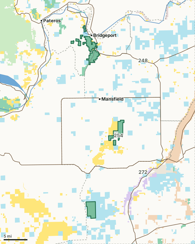
National forestBLMDNR state trust landWDFW landNational wildlife refuge (refuge rules; not counted)Bureau of ReclamationMilitary land (restricted)Other public (parks, county, city, other agencies)Sagebrush Flat Wildlife AreaGMU lineLake or riverHighway
| Size | 14,082 acres (WDFW boundary, measured by FilledTag) |
|---|---|
| WDFW region | Region 2, North Central Washington |
| GMUs | GMU 260, GMU 272, GMU 254, GMU 248 |
| Units | 4 |
| Roads and trails | 57 miles |
| Parking areas | 8 |
| Nearest towns | Bridgeport (next to it), Brewster (6 mi) and Mansfield (6 mi) |
What is the Sagebrush Flat Wildlife Area like?
Sagebrush Flat Wildlife Area is located in Douglas County and covers approximately 14,100 acres of land. The wildlife area is predominantly shrubsteppe, a habitat that is essential to the survival of three state-listed species (Columbian sharp-tailed grouse, greater sage grouse, and pygmy rabbit), as well as other shrubsteppe dependent species and wildlife.
In WDFW's words, from WDFW's Sagebrush Flat Wildlife Area page.
What units make up the Sagebrush Flat Wildlife Area?
WDFW manages the area as 4 units. The largest is Bridgeport at 6,551 acres.
| Unit | Acres | GMUs | Parking areas | Campgrounds | Hunting blinds |
|---|---|---|---|---|---|
| Bridgeport | 6,551 | 248, 260 | 6 | 0 | 0 |
| Sagebrush Flat | 4,306 | 254, 272 | 0 | 0 | 0 |
| Chester Butte | 2,905 | 254 | 2 | 0 | 0 |
| Dormaier | 321 | 254 | 0 | 0 | 0 |
Unit outlines and facilities: WDFW wildlife area and unit boundaries. Acres measured by FilledTag.
WDFW's notes for each unit
Bridgeport: All lands in Washington State are CLOSED to the taking of sharp-tailed grouse and sage grouse. Upland bird hunters are advised that these are protected species and can be found anywhere on the unit. Hunters should be alert to the presence of these birds on this area and be proficient at identifying them. WDFW
Sagebrush Flat: All lands in Washington State are CLOSED to the taking of greater sage grouse and pygmy rabbits. Small game and upland bird hunters are advised that these are protected species and can be found anywhere on the unit. Hunters should be alert to their presence and be proficient at identifying them. WDFW
Chester Butte: All lands in Washington State are CLOSED to the taking of greater sage grouse and pygmy rabbits. Small game and upland bird hunters are advised that these are protected species and can be found anywhere on the unit. Hunters should be alert to their presence and be proficient at identifying them. WDFW
Dormaier: All lands in Washington State are CLOSED to the taking of greater sage grouse and pygmy rabbits. Small game and upland bird hunters are advised that these are protected species and can be found anywhere on the unit. Hunters should be alert to their presence and be proficient at identifying them. WDFW
How many elk and deer are taken in the GMUs around the Sagebrush Flat Wildlife Area?
WDFW reports harvest by GMU, not by wildlife area. These are the whole GMUs the area lies in:
| GMU | Wildlife area acres in it | Elk taken, 2025 | Deer taken, 2025 | Bears taken, 2025 |
|---|---|---|---|---|
| GMU 260 Foster Creek | 4,989 | 0 | 65 | 0 |
| GMU 272 Beezley | 3,825 | 26 | 337 | 0 |
| GMU 254 Saint Andrews | 3,706 | 0 | 80 | 0 |
| GMU 248 Big Bend | 1,561 | 0 | 126 | 9 |
Harvest: WDFW Game Harvest Reports (GMU, 2025). Wildlife area acres in each GMU measured by FilledTag from WDFW's boundaries.
How do you get to the Sagebrush Flat Wildlife Area?
Highways within 5 miles: SR 17, SR 173, SR 172, US 97 and US 2. Nearest towns: Bridgeport (next to it), Brewster (6 miles), Mansfield (6 miles) and Pateros (8 miles).
Questions hunters ask
Do you need a pass to park at the Sagebrush Flat Wildlife Area?
Yes. Parking on WDFW land needs the Vehicle Access Pass that comes with most annual hunting and fishing licenses, or a Discover Pass, displayed where it can be seen from outside the vehicle (WDFW pamphlet, page 72).
Which GMUs is the Sagebrush Flat Wildlife Area in?
GMU 260 Foster Creek (4,989 acres), GMU 272 Beezley (3,825 acres), GMU 254 Saint Andrews (3,706 acres) and GMU 248 Big Bend (1,561 acres), by WDFW's boundaries. Seasons follow each GMU's rules.
Can you camp on the Sagebrush Flat Wildlife Area?
WDFW's facility data lists no developed campground on the Sagebrush Flat Wildlife Area. Camping on WDFW land follows WDFW's public conduct rules and any closures posted for the area; check WDFW's page before planning a camp.
Get a Washington hunt plan when they open
Hunt plans for Washington are coming. Join the list and you'll hear first. The first 50 hunters in each new state get their plan free.
Until then, the free FilledTag app for iPhone has a map that works in every state, Washington included.
Where these facts come from
- Area description, rules and access notes: WDFW, Sagebrush Flat Wildlife Area.
- Boundary, units and facilities: WDFW wildlife area and unit boundaries. Surrounding public land: WA DNR Major Public Lands (non-DNR) and WA DNR Managed Land Parcels, read 2026-10.
- GMU harvest: WDFW Game Harvest Reports. Parking passes: WDFW 2026 Big Game Hunting Seasons and Regulations, page 72.
FilledTag is not part of Washington Department of Fish and Wildlife. Numbers are copied from WDFW and the State of Washington, or measured from their maps; nothing on this page is estimated by FilledTag. WDFW's regulations are the final word on every rule.