Deer Creek Wildlife Area: hunting and access
Deer Creek Wildlife Area is 1,489 acres of land managed by the Wisconsin DNR in Outagamie and Waupaca counties, 4 miles from Bear Creek. The DNR's page for it names deer, wild turkey, ducks and geese and ruffed grouse among the game here. Hunters registered 4,322 deer in Outagamie County in 2025.
Data updated October 2026. Area facts: the DNR's DNR property data, read 2026-10. Harvest: DNR Deer Metrics.
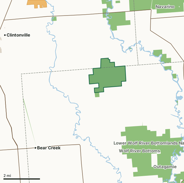
State wildlife areas, forests and other DNR landOther county, city and regional landVoluntary Public Access landDeer Creek Wildlife AreaCounty lineLakeHighway
| Size | 1,489 acres |
|---|---|
| Counties | Outagamie County and Waupaca County |
| Deer Management Unit | Outagamie County, Waupaca County |
| DNR lists for hunting | deer, wild turkey, ducks and geese and ruffed grouse |
| Public access (DNR) | Open to Hiking, Fishing, Hunting and Trapping |
| DNR property page | Deer Creek Wildlife Area |
| Nearest towns | Bear Creek (4 mi), Clintonville (5 mi) and Embarrass (6 mi) |
What is Deer Creek Wildlife Area like?
Deer Creek Wildlife Area is located in northeast Waupaca and northwest Outagamie counties. The wildlife area is approximately 1,500 acres in size. Find Deer Creek Wildlife Area 5 miles west of Leeman off of Highway F. There are three parking areas providing access to the property. Two are located on County Highway I near Hanson Road and the other is found on the corner of Birch Road. There is an easement on the end of Spruce Road providing access to the property. The wildlife area is comprised of rolling uplands of fine sand which surround a central peat bog. The ridges are ancient dune complexes from the fringes of Glacial Lake Oshkosh. Habitats include aspen-oak forests, swamp conifer, lowland shrub, sedge meadow, bog, pine plantations, and restored grasslands.
Deer Creek Wildlife Area began with the purchase of 440 acres from Outagamie County in 1942. Additional land was acquired and leased for public hunting within and around the property. These lands were stocked with pheasants for public hunting at that time. As late as 1957, small numbers of greater prairie chickens and sharp-tailed grouse were present in the area. Since state ownership, vegetative succession has resulted in management aimed at more forest-dependent species. White-tailed deer, ruffed grouse, cottontail rabbit, and snowshoe hare take advantage of the aspen-dominated habitats present. The Deer Creek Wildlife Area is managed to provide opportunities for public hunting, trapping and other outdoor recreation while protecting the qualities of the unique native communities and associated species found on the property.
In the DNR's words, from its page for the property.
What can you hunt on Deer Creek Wildlife Area?
The DNR's page for Deer Creek Wildlife Area names deer, wild turkey, ducks and geese and ruffed grouse. Each follows Wisconsin's statewide season and, for deer, the tags and rules of the deer management unit.
What are the rules on Deer Creek Wildlife Area?
The DNR's property map lists Deer Creek Wildlife Area as "Open to Hiking, Fishing, Hunting and Trapping". Hunting follows Wisconsin's statewide seasons and the rules posted on the property.
Activities the DNR lists for Deer Creek Wildlife Area: Birding, Cross-country skiing (no designated trail), Hiking (no designated trail), Hunting (noted for deer, turkey, grouse and waterfowl), Snowmobiling trail, Trapping, Wild edibles/gathering and Wildlife viewing.
How many deer are taken around Deer Creek Wildlife Area?
Deer Creek Wildlife Area lies in 2 deer management units. The DNR registered 4,322 deer in Outagamie County in 2025, against 4,318 in 2024.
| DMU | Deer Creek Wildlife Area acres in it | Deer, 2025 | Deer, 2024 | Deer, 2023 |
|---|---|---|---|---|
| Outagamie County | 1,296 | 4,322 | 4,318 | 3,847 |
| Waupaca County | 194 | 10,740 | 10,349 | 9,097 |
Harvest for the whole deer management unit, not the property alone: Wisconsin DNR Deer Metrics (registered harvest by deer management unit).
How do you get to Deer Creek Wildlife Area?
Nearest towns: Bear Creek (4 miles), Clintonville (5 miles), Embarrass (6 miles) and Navarino (6 miles). Highways within 5 miles: WI 156, WI 187, WI 76, US 45 and WI 22.
What other public land is near Deer Creek Wildlife Area?
DNR properties within 10 miles:
- Lower Wolf River Bottomlands Natural Resource Area: 3,670 acres, next to it
- Navarino Wildlife Area: 14,533 acres, 1.5 miles away
- Wolf River Bottoms Wildlife Area: 3,142 acres, 2.3 miles away
- Wiouwash State Trail: 277 acres, 3.7 miles away
- Maine Wildlife Area: 675 acres, 4.2 miles away
- Outagamie Wildlife Area: 944 acres, 4.4 miles away
Public land within 3 miles of Deer Creek Wildlife Area
Counting Deer Creek Wildlife Area itself, 3,089 of the 32,001 acres within 3 miles of its boundary are public land open to the public (9.7%), by USGS PAD-US 4.1 (fee land open to the public).
| Manager | Acres within 3 miles |
|---|---|
| State wildlife areas, forests and other DNR land | 3,089 |
Questions hunters ask
Where is Deer Creek Wildlife Area?
In Outagamie and Waupaca counties, 4 miles from Bear Creek. The DNR's property page has its maps and parking.
Is Deer Creek Wildlife Area open to hunting?
Yes. The DNR's property map lists it as "Open to Hiking, Fishing, Hunting and Trapping". Posted refuges or closed areas, where there are any, are marked on site.
Which deer management unit is Deer Creek Wildlife Area in?
Outagamie County (1,296 acres) and Waupaca County (194 acres).
How much public land is around Deer Creek Wildlife Area?
3,089 acres within 3 miles of its boundary, Deer Creek Wildlife Area included, by PAD-US 4.1. The closest other DNR property is Lower Wolf River Bottomlands Natural Resource Area (next to it).
Get a Wisconsin hunt plan when they open
Hunt plans for Wisconsin are coming. Join the list and you'll hear first. The first 50 hunters in each new state get their plan free.
Until then, the free FilledTag app for iPhone has a map that works in every state, Wisconsin included.
Where these facts come from
- Area description, species, rules and directions: DNR, Deer Creek Wildlife Area; Wisconsin DNR managed lands open to hunting.
- Boundary and acres: the DNR's map layer above. Surrounding public land: USGS PAD-US 4.1 (fee land open to the public).
- Deer harvest: Wisconsin DNR Deer Metrics (registered harvest by deer management unit).
FilledTag is not part of the Wisconsin Department of Natural Resources. Check the DNR's rules and posted signs before you go.
Wisconsin hunting Outagamie County Waupaca County Outagamie County Waupaca County