Maine Wildlife Area: hunting and access
Maine Wildlife Area is 675 acres of land managed by the Wisconsin DNR in Outagamie County, 3 miles from Nichols. The DNR's page for it names deer, wild turkey and ruffed grouse among the game here. Hunters registered 4,322 deer in Outagamie County in 2025.
Data updated October 2026. Area facts: the DNR's DNR property data, read 2026-10. Harvest: DNR Deer Metrics.
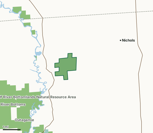
State wildlife areas, forests and other DNR landNational wildlife refuges and waterfowl production areasMaine Wildlife AreaCounty lineLakeHighway
| Size | 675 acres |
|---|---|
| County | Outagamie County |
| Deer Management Unit | Outagamie County |
| DNR lists for hunting | deer, wild turkey and ruffed grouse |
| Public access (DNR) | Open to Hiking, Fishing, Hunting and Trapping |
| DNR property page | Maine Wildlife Area |
| Nearest towns | Nichols (3 mi), Navarino (4 mi) and Black Creek (6 mi) |
What is Maine Wildlife Area like?
Maine Wildlife Area is in northcentral Outagamie County with the state owning approximately 720 acres. The wildlife area is comprised of extensive wetlands on nearly level terrain, with scattered low upland ridges on fine sand-dune complexes from the margins of extinct glacial lakes. The wetlands consist of sedge meadow, shrub swamp and tamarack bog. The low ridges are forested with aspen, oaks, red maple, paper birch, basswood, green ash and sugar maple.
The acquisition at Maine began in 1942 with the purchase of some tax-delinquent land by the Wisconsin Conservation Commission. The only major development project was the creation of a level ditch, which connects several dug ponds. The property currently is managed for forest and wetland wildlife. Find Maine Wildlife Area 7 miles north of Shiocton. There is one parking area for the property located on Beyer Road. Access is better under frozen ground conditions. The Maine Wildlife Area is managed to provide opportunities for public hunting, trapping and other outdoor recreation while protecting the qualities of the native communities and associated species found on the property. The aspen and oak cover types are maintained along the ridges and opportunities to regenerate both types are pursued through timber management. The Maine Wildlife Area offers many recreational opportunities:.
In the DNR's words, from its page for the property.
What can you hunt on Maine Wildlife Area?
The DNR's page for Maine Wildlife Area names deer, wild turkey and ruffed grouse. Each follows Wisconsin's statewide season and, for deer, the tags and rules of the deer management unit.
What are the rules on Maine Wildlife Area?
The DNR's property map lists Maine Wildlife Area as "Open to Hiking, Fishing, Hunting and Trapping". Hunting follows Wisconsin's statewide seasons and the rules posted on the property.
Activities the DNR lists for Maine Wildlife Area: Birding, Cross-country skiing (no designated trail), Hiking (no designated trail), Hunting (noted for deer, grouse and turkey) and Trapping.
How many deer are taken around Maine Wildlife Area?
Maine Wildlife Area lies in Outagamie County. The DNR registered 4,322 deer in Outagamie County in 2025, against 4,318 in 2024.
| DMU | Maine Wildlife Area acres in it | Deer, 2025 | Deer, 2024 | Deer, 2023 |
|---|---|---|---|---|
| Outagamie County | 675 | 4,322 | 4,318 | 3,847 |
Harvest for the whole deer management unit, not the property alone: Wisconsin DNR Deer Metrics (registered harvest by deer management unit).
How do you get to Maine Wildlife Area?
Nearest towns: Nichols (3 miles), Navarino (4 miles), Black Creek (6 miles) and Shiocton (7 miles). Highways within 5 miles: WI 187, WI 47, WI 156 and WI 54.
What other public land is near Maine Wildlife Area?
DNR properties within 10 miles:
- Lower Wolf River Bottomlands Natural Resource Area: 3,670 acres, 1 mile away
- Wolf River Bottoms Wildlife Area: 3,142 acres, 2.3 miles away
- Outagamie Wildlife Area: 944 acres, 2.4 miles away
- Mack Wildlife Area: 1,846 acres, 4.2 miles away
- Deer Creek Wildlife Area: 1,489 acres, 4.2 miles away
Public land within 3 miles of Maine Wildlife Area
Counting Maine Wildlife Area itself, 2,513 of the 27,457 acres within 3 miles of its boundary are public land open to the public (9.2%), by USGS PAD-US 4.1 (fee land open to the public).
| Manager | Acres within 3 miles |
|---|---|
| State wildlife areas, forests and other DNR land | 2,510 |
| National wildlife refuges and waterfowl production areas | 3 |
Questions hunters ask
Where is Maine Wildlife Area?
In Outagamie County, 3 miles from Nichols. The DNR's property page has its maps and parking.
Is Maine Wildlife Area open to hunting?
Yes. The DNR's property map lists it as "Open to Hiking, Fishing, Hunting and Trapping". Posted refuges or closed areas, where there are any, are marked on site.
Which deer management unit is Maine Wildlife Area in?
Outagamie County.
How much public land is around Maine Wildlife Area?
2,513 acres within 3 miles of its boundary, Maine Wildlife Area included, by PAD-US 4.1. The closest other DNR property is Lower Wolf River Bottomlands Natural Resource Area (1 mile).
Get a Wisconsin hunt plan when they open
Hunt plans for Wisconsin are coming. Join the list and you'll hear first. The first 50 hunters in each new state get their plan free.
Until then, the free FilledTag app for iPhone has a map that works in every state, Wisconsin included.
Where these facts come from
- Area description, species, rules and directions: DNR, Maine Wildlife Area; Wisconsin DNR managed lands open to hunting.
- Boundary and acres: the DNR's map layer above. Surrounding public land: USGS PAD-US 4.1 (fee land open to the public).
- Deer harvest: Wisconsin DNR Deer Metrics (registered harvest by deer management unit).
FilledTag is not part of the Wisconsin Department of Natural Resources. Check the DNR's rules and posted signs before you go.