Dunnville Wildlife Area: hunting and access
Dunnville Wildlife Area is 4,357 acres of land managed by the Wisconsin DNR in Dunn and Pepin counties, 3 miles from Downsville. The DNR's page for it names deer, wild turkey, pheasants, ducks and geese, woodcock and small game among the game here. Hunters registered 9,118 deer in Dunn County in 2025.
Data updated October 2026. Area facts: the DNR's DNR property data, read 2026-10. Harvest: DNR Deer Metrics.
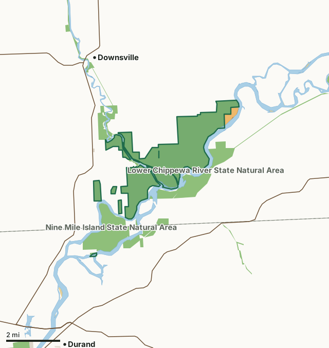
State wildlife areas, forests and other DNR landOther federal landState parksOther county, city and regional landLand trusts and other open landVoluntary Public Access landDunnville Wildlife AreaCounty lineLakeHighway
| Size | 4,357 acres in 10 pieces |
|---|---|
| Counties | Dunn County and Pepin County |
| Deer Management Unit | Dunn County, Pepin County |
| DNR lists for hunting | deer, wild turkey, pheasants, ducks and geese, woodcock and small game |
| Public access (DNR) | Open to Hiking, Fishing, Hunting and Trapping |
| DNR property page | Dunnville Wildlife Area |
| Nearest towns | Downsville (3 mi), Durand (3 mi) and Arkansaw (5 mi) |
What is Dunnville Wildlife Area like?
Dunnville Wildlife Area, commonly referred to locally as the "Dunnville Bottoms," is a 4,200-acre property located between Menomonie and Durand, bound by the Chippewa River on the south and County Highway Y and 210th Avenue on the north. Access to this property can be gained through four parking areas off of Highway Y or through numerous parking areas off of the following town roads: 524th, 580th, 640th and 660th streets. Access to the south side of the property is also possible via boat from the Chippewa River. Habitat on the Dunnville Wildlife Area is quite diverse. Expansive sand beaches are common along the Chippewa River. Moving inland, large areas of floodplain forest are common. Interspersed within this forest environment are backwater sloughs and some rather large openings containing prairie and oak savanna.
Nearly a quarter of the wildlife area's acreage (more than 900 acres) is managed as prairie or oak savanna, including approximately 200 acres of native remnants that have never been farmed. The Dunnville Wildlife Area started as a leased public hunting ground in 1951 in response to a petition from the Dunn County Fish and Game Association to the Wisconsin Conservation Department. The original lease was on 3,200 acres. In 1952, the Conservation Department purchased 40 acres from Dunn County under the authority of the Scattered Wetlands Program. In 1967, Dunnville Wildlife Area was established as a project with a goal of 3,507 acres. In 1979, the acreage goal was revised to the current 5,707 acres. This wildlife area is currently an active acquisition area, with additional lands added as recently as 2009.
In the DNR's words, from its page for the property.
What can you hunt on Dunnville Wildlife Area?
The DNR's page for Dunnville Wildlife Area names deer, wild turkey, pheasants, ducks and geese, woodcock and small game. Each follows Wisconsin's statewide season and, for deer, the tags and rules of the deer management unit.
What are the rules on Dunnville Wildlife Area?
The DNR's property map lists Dunnville Wildlife Area as "Open to Hiking, Fishing, Hunting and Trapping". Hunting follows Wisconsin's statewide seasons and the rules posted on the property.
Activities the DNR lists for Dunnville Wildlife Area: Auto travel, Biking (Red Cedar State Trail), Birding, Boating (motorized and non-motorized), Canoeing, Cross-country skiing (no designated trail), Fishing, Hiking (Red Cedar State Trail) and Hunting (noted for deer, turkey, pheasant, waterfowl, woodcock and small game) Noon closure for pheasant hunting.
How many deer are taken around Dunnville Wildlife Area?
Dunnville Wildlife Area lies in 2 deer management units. The DNR registered 9,118 deer in Dunn County in 2025, against 7,819 in 2024.
| DMU | Dunnville Wildlife Area acres in it | Deer, 2025 | Deer, 2024 | Deer, 2023 |
|---|---|---|---|---|
| Dunn County | 4,345 | 9,118 | 7,819 | 6,979 |
| Pepin County | 12 | 2,215 | 2,120 | 1,904 |
Harvest for the whole deer management unit, not the property alone: Wisconsin DNR Deer Metrics (registered harvest by deer management unit).
How do you get to Dunnville Wildlife Area?
Nearest towns: Downsville (3 miles), Durand (3 miles), Arkansaw (5 miles) and Rock Falls (6 miles). Highways within 5 miles: WI 25, WI 85, US 10 and WI 72. 1 VPA property within 3 miles.
What other public land is near Dunnville Wildlife Area?
DNR properties within 10 miles:
- Nine Mile Island State Natural Area: 1,319 acres, next to it
- Lower Chippewa River State Natural Area: 3,486 acres, next to it
- Red Cedar State Trail: 392 acres, next to it
- Chippewa River State Trail: 306 acres, 0.8 miles away
Public land within 3 miles of Dunnville Wildlife Area
Counting Dunnville Wildlife Area itself, 7,447 of the 60,942 acres within 3 miles of its boundary are public land open to the public (12.2%), by USGS PAD-US 4.1 (fee land open to the public).
| Manager | Acres within 3 miles |
|---|---|
| State wildlife areas, forests and other DNR land | 7,380 |
| Other federal land | 54 |
| State parks | 7 |
| Other county, city and regional land | 6 |
Questions hunters ask
Where is Dunnville Wildlife Area?
In Dunn and Pepin counties, 3 miles from Downsville. The DNR's property page has its maps and parking.
Is Dunnville Wildlife Area open to hunting?
Yes. The DNR's property map lists it as "Open to Hiking, Fishing, Hunting and Trapping". Posted refuges or closed areas, where there are any, are marked on site.
Which deer management unit is Dunnville Wildlife Area in?
Dunn County (4,345 acres) and Pepin County (12 acres).
How much public land is around Dunnville Wildlife Area?
7,447 acres within 3 miles of its boundary, Dunnville Wildlife Area included, by PAD-US 4.1. The closest other DNR property is Nine Mile Island State Natural Area (next to it).
Get a Wisconsin hunt plan when they open
Hunt plans for Wisconsin are coming. Join the list and you'll hear first. The first 50 hunters in each new state get their plan free.
Until then, the free FilledTag app for iPhone has a map that works in every state, Wisconsin included.
Where these facts come from
- Area description, species, rules and directions: DNR, Dunnville Wildlife Area; Wisconsin DNR managed lands open to hunting.
- Boundary and acres: the DNR's map layer above. Surrounding public land: USGS PAD-US 4.1 (fee land open to the public).
- Deer harvest: Wisconsin DNR Deer Metrics (registered harvest by deer management unit).
FilledTag is not part of the Wisconsin Department of Natural Resources. Check the DNR's rules and posted signs before you go.
Wisconsin hunting Dunn County Pepin County Dunn County Pepin County