Pepin County, Wisconsin: deer harvest and public hunting land
Pepin County is its own deer management unit, 249 square miles around Durand. Hunters registered 2,215 deer here in 2025, 927 of them bucks, by the DNR's Deer Metrics. That is up 4% from 2024. 3.7% of Pepin County is public land open to the public, the largest share state wildlife areas, forests and other DNR land (5,699 acres), by USGS PAD-US 4.1 (fee land open to the public).
Data updated October 2026. Harvest: DNR Deer Metrics. Land: PAD-US 4.1, the DNR's managed lands and VPA layers.
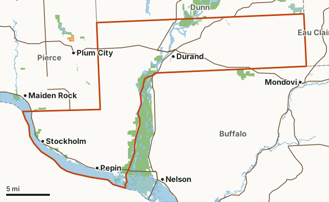
State wildlife areas, forests and other DNR landNational wildlife refuges and waterfowl production areasOther federal landOther county, city and regional landLand trusts and other open landVoluntary Public Access landPepin CountyNeighboring deer management unitsLakeHighway
| Counties | Pepin County |
|---|---|
| Size | 159,099 acres (249 square miles) |
| Deer registered, 2025 | 2,215 (927 bucks, 1,288 antlerless) |
| Yearly average, 2016 to 2025 | 2,213 deer |
| Public land | 3.7% (5,834 acres) |
| Properties | 6 (5,242 acres inside Pepin County) |
| Voluntary Public Access land | None mapped this year |
| Towns in and near it | Durand, Stockholm, Pepin, Mondovi, Maiden Rock and Plum City |
How many deer are harvested in Pepin County?
The DNR registered 2,215 deer in Pepin County in 2025: 927 bucks and 1,288 antlerless deer, 58% of the harvest antlerless. Over the 10 years shown, the harvest averaged 2,213 deer a year; the most bucks were registered in 2020 (1,004).
| Year | Deer registered | Bucks | Antlerless | Antlerless share |
|---|---|---|---|---|
| 2025 | 2,215 | 927 | 1,288 | 58% |
| 2024 | 2,120 | 884 | 1,236 | 58% |
| 2023 | 1,904 | 819 | 1,085 | 57% |
| 2022 | 2,215 | 975 | 1,240 | 56% |
| 2021 | 2,028 | 911 | 1,117 | 55% |
| 2020 | 2,395 | 1,004 | 1,391 | 58% |
| 2019 | 2,086 | 923 | 1,163 | 56% |
| 2018 | 2,257 | 877 | 1,380 | 61% |
| 2017 | 2,212 | 934 | 1,278 | 58% |
| 2016 | 2,699 | 1,001 | 1,698 | 63% |
Source: Wisconsin DNR Deer Metrics, harvest history for Pepin County. Deer registered is the DNR's buck and antlerless harvest added together. The DNR's Deer Metrics shows every year back to 1960 for most counties.
How much public land is in Pepin County?
5,834 of Pepin County's 159,099 acres are public land open to the public (3.7%). The biggest share is state wildlife areas, forests and other DNR land: 5,699 acres.
| Manager | Acres | Share of Pepin County |
|---|---|---|
| State wildlife areas, forests and other DNR land | 5,699 | 3.6% |
| Other federal land | 57 | under 0.1% |
| Land trusts and other open land | 50 | under 0.1% |
| Other county, city and regional land | 28 | under 0.1% |
| All public land open to the public | 5,834 | 3.7% |
Measured by FilledTag inside the DNR's boundary from USGS PAD-US 4.1 (fee land open to the public). Hunting rules differ by manager: DNR wildlife areas and state forests are open to hunting unless posted; county forests are open to hunting in most cases (check the county forest's rules); national forest land is open in season; refuges follow U.S. Fish and Wildlife Service rules; state parks allow hunting only in listed seasons and areas; national park land is closed to hunting.
DNR properties in Pepin County
DNR properties in Pepin County, largest first, with the acres of each inside it:
- Tiffany Wildlife Area: 3,476 acres
- Nine Mile Island State Natural Area: 889 acres
- Lower Chippewa River State Natural Area: 352 acres
- Maiden Rock Bluff State Natural Area: 263 acres
- Lake Pepin Wildlife Area: 250 acres
- Dunnville Wildlife Area: 12 acres
Other large public areas here, by PAD-US: Extensive Wl Habitat - Public Hunting Ground (315 acres).
How do you get to Pepin County?
Highways through it: US 10 (about 18 miles inside), WI 35 (about 15 miles inside), WI 25 (about 10 miles inside) and WI 85 (about 8 miles inside). Towns inside: Durand, Stockholm, Pepin and Arkansaw. Nearby: Mondovi (2 miles), Maiden Rock (2 miles), Plum City (3 miles) and Nelson (4 miles).
Which deer management units border Pepin County?
Pepin County touches 4 other deer management units. Their latest DNR harvest and public land, for comparison:
| DMU | Deer harvested | Year | Public land | Voluntary Public Access land sites |
|---|---|---|---|---|
| Dunn County | 9,118 | 2025 | 3.7% | 3 |
| Pierce County | 4,366 | 2025 | 1.7% | 5 |
| Buffalo County | 5,806 | 2025 | 5.6% | |
| DMU Eau Claire | 3,672 | 2025 | 2.9% | 1 |
Questions hunters ask
How many deer were harvested in Pepin County in 2025?
2,215 deer were registered: 927 bucks and 1,288 antlerless deer (DNR Deer Metrics). In 2024: 2,120.
Is there public hunting land in Pepin County?
Yes. 5,834 acres, 3.7% of the unit, are public land open to the public by PAD-US 4.1, the largest share state wildlife areas, forests and other DNR land (5,699 acres). The DNR's map shows 6 DNR properties open to hunting here.
Does Pepin County have VPA land?
Not on the DNR's 2026 lease map.
Get a Wisconsin hunt plan when they open
Hunt plans for Wisconsin are coming. Join the list and you'll hear first. The first 50 hunters in each new state get their plan free.
Until then, the free FilledTag app for iPhone has a map that works in every state, Wisconsin included.
Where these numbers come from
- Deer harvest: Wisconsin DNR Deer Metrics (registered harvest by deer management unit).
- Public land: USGS PAD-US 4.1 (fee land open to the public). DNR properties: Wisconsin DNR managed lands open to hunting. Voluntary Public Access land: Wisconsin DNR Voluntary Public Access and Turkey Hunting Program lands.
- Boundaries: Wisconsin DNR deer management units. Highways and towns: U.S. Census Bureau TIGER/Line 2024 primary and secondary roads; U.S. Census Bureau 2024 Gazetteer, places.
FilledTag is not part of the Wisconsin Department of Natural Resources. Numbers are copied from the DNR and the federal sources above, or measured from their maps; nothing on this page is estimated by FilledTag.