Lower Chippewa River State Natural Area: hunting and access
Lower Chippewa River State Natural Area is 3,486 acres of land managed by the Wisconsin DNR in Dunn, Eau Claire and Pepin counties, next to Downsville. Hunters registered 9,118 deer in Dunn County in 2025.
Data updated October 2026. Area facts: the DNR's DNR property data, read 2026-10. Harvest: DNR Deer Metrics.
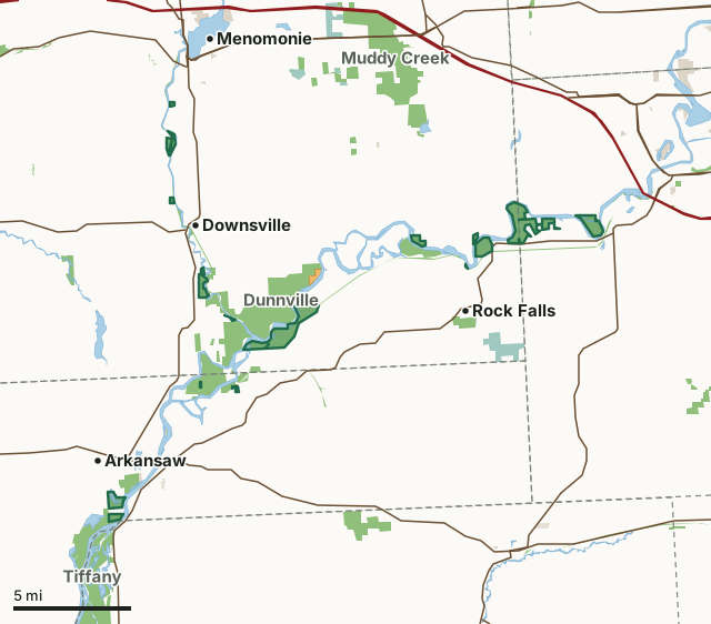
State wildlife areas, forests and other DNR landNational wildlife refuges and waterfowl production areasOther federal landOther county, city and regional landLand trusts and other open landVoluntary Public Access landLower Chippewa River State Natural AreaCounty lineLakeHighway
| Size | 3,486 acres in 22 pieces |
|---|---|
| Counties | Dunn County, Eau Claire County and Pepin County |
| Deer Management Unit | Dunn County, DMU Eau Claire, Pepin County |
| Public access (DNR) | Open to Hiking, Fishing, Hunting and Trapping |
| DNR property page | Lower Chippewa River |
| Nearest towns | Downsville (next to it), Arkansaw (next to it) and Rock Falls (2 mi) |
What is Lower Chippewa River State Natural Area like?
The Lower Chippewa River State Natural Area features the largest concentration of remaining prairies and savannas in the state. At the time of European settlement Wisconsin had over 7.7 million acres of the native prairie but today only about 8,000 acres remain. This extensive project contains over 2,000 acres of prairie, which equals 25% of all known remaining prairie in the entire state. Lying along and interspersed within the river channels are islands of floodplain savanna and forest while the surrounding hillsides contain prairie and savanna. The largest contiguous floodplain forest in the Midwest is located just south of Durand within this natural area. A large diversity of birds thrive in these extensive forests including many forest interior species.
Buffalo, Dunn, and Pepin Counties. T24N-R12W, Sections 1, 2. T25N-R13W, Sections 7, 30, 31. T26N-R10W, Sections 3-6. T26N-R11W, Sections 1, 2, 5, 11. T26N-R13W, Sections 11, 14. 3,537 acres. From Durand, the site lies north and south along the Chippewa River. The project encompasses 15,000 acres with many scattered sites. Look for State Natural Area signs or contact any DNR office and request the present locations of sites accessible to the public. Lower Chippewa River is owned by the Wisconsin DNR and Mississippi Valley Conservancy.
In the DNR's words, from its page for the property.
What are the rules on Lower Chippewa River State Natural Area?
The DNR's property map lists Lower Chippewa River State Natural Area as "Open to Hiking, Fishing, Hunting and Trapping". Hunting follows Wisconsin's statewide seasons and the rules posted on the property.
How many deer are taken around Lower Chippewa River State Natural Area?
Lower Chippewa River State Natural Area lies in 3 deer management units. The DNR registered 9,118 deer in Dunn County in 2025, against 7,819 in 2024.
| DMU | Lower Chippewa River State Natural Area acres in it | Deer, 2025 | Deer, 2024 | Deer, 2023 |
|---|---|---|---|---|
| Dunn County | 2,264 | 9,118 | 7,819 | 6,979 |
| DMU Eau Claire | 875 | 3,672 | ||
| Pepin County | 352 | 2,215 | 2,120 | 1,904 |
Harvest for the whole deer management unit, not the property alone: Wisconsin DNR Deer Metrics (registered harvest by deer management unit).
How do you get to Lower Chippewa River State Natural Area?
Nearest towns: Downsville (next to it), Arkansaw (next to it), Rock Falls (2 miles) and Durand (2 miles). Highways within 5 miles: I-94, WI 25, WI 85, US 12 and US 10. 1 VPA property within 3 miles.
What other public land is near Lower Chippewa River State Natural Area?
DNR properties within 10 miles:
- Tiffany Wildlife Area: 14,019 acres, next to it
- Nine Mile Island State Natural Area: 1,319 acres, next to it
- Dunnville Wildlife Area: 4,357 acres, next to it
- Chippewa River State Trail: 306 acres, next to it
- Red Cedar State Trail: 392 acres, next to it
Public land within 3 miles of Lower Chippewa River State Natural Area
Counting Lower Chippewa River State Natural Area itself, 13,487 of the 169,816 acres within 3 miles of its boundary are public land open to the public (7.9%), by USGS PAD-US 4.1 (fee land open to the public).
| Manager | Acres within 3 miles |
|---|---|
| State wildlife areas, forests and other DNR land | 13,114 |
| Other county, city and regional land | 141 |
| Other federal land | 121 |
| Land trusts and other open land | 54 |
| State parks | 31 |
| National wildlife refuges and waterfowl production areas | 26 |
Questions hunters ask
Where is Lower Chippewa River State Natural Area?
In Dunn, Eau Claire and Pepin counties, next to Downsville. The DNR's property page has its maps and parking.
Is Lower Chippewa River State Natural Area open to hunting?
Yes. The DNR's property map lists it as "Open to Hiking, Fishing, Hunting and Trapping". Posted refuges or closed areas, where there are any, are marked on site.
Which deer management unit is Lower Chippewa River State Natural Area in?
Dunn County (2,264 acres), DMU Eau Claire (875 acres) and Pepin County (352 acres).
How much public land is around Lower Chippewa River State Natural Area?
13,487 acres within 3 miles of its boundary, Lower Chippewa River State Natural Area included, by PAD-US 4.1. The closest other DNR property is Tiffany Wildlife Area (next to it).
Get a Wisconsin hunt plan when they open
Hunt plans for Wisconsin are coming. Join the list and you'll hear first. The first 50 hunters in each new state get their plan free.
Until then, the free FilledTag app for iPhone has a map that works in every state, Wisconsin included.
Where these facts come from
- Area description, species, rules and directions: DNR, Lower Chippewa River State Natural Area; Wisconsin DNR managed lands open to hunting.
- Boundary and acres: the DNR's map layer above. Surrounding public land: USGS PAD-US 4.1 (fee land open to the public).
- Deer harvest: Wisconsin DNR Deer Metrics (registered harvest by deer management unit).
FilledTag is not part of the Wisconsin Department of Natural Resources. Check the DNR's rules and posted signs before you go.
Wisconsin hunting Dunn County Eau Claire County Pepin County Dunn County Pepin County