Mullet Creek Wildlife Area: hunting and access
Mullet Creek Wildlife Area is 2,245 acres of land managed by the Wisconsin DNR in Fond du Lac County, 4 miles from Greenbush. Hunters registered 4,642 deer in Fond du Lac County in 2025.
Data updated October 2026. Area facts: the DNR's DNR property data, read 2026-10. Harvest: DNR Deer Metrics.
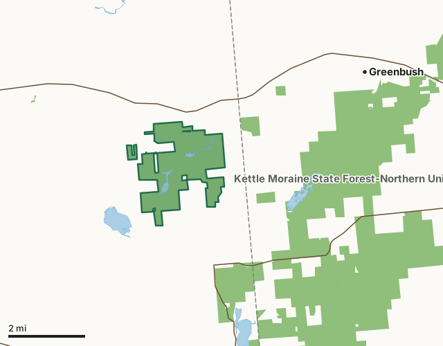
State wildlife areas, forests and other DNR landMullet Creek Wildlife AreaCounty lineLakeHighway
| Size | 2,245 acres in 2 pieces |
|---|---|
| County | Fond du Lac County |
| Deer Management Unit | Fond du Lac County |
| Public access (DNR) | Open to Hiking, Fishing, Hunting and Trapping |
| DNR property page | Mullet Creek Wildlife Area |
| Nearest towns | Greenbush (4 mi), St. Cloud (4 mi) and Mount Calvary (4 mi) |
What is Mullet Creek Wildlife Area like?
Mullet Creek Wildlife Area is a 2,217-acre property located in east-central Fond du Lac County. The wildlife area is located 15 miles east of Fond du Lac and 10 miles west of Plymouth on Highway 23. Travel south of Highway 23 on County Trunk G for 1 mile to the northeast corner of the wildlife area. This is where Mullet Creek flows under County Trunk G. Mullet Creek Wildlife Area consists of a rich array of wetland, forest, grassland and farmland. Mullet Creek flows through the entire property, eventually joining the Sheboygan River. The central portion of this property consists of shallow open water with submerged vegetation and a cattail wetland totaling over 700 acres. Sedge, reed canary grass, willow, dogwood, swamp conifers and swamp hardwoods occur in the lowland areas.
The Mullet Creek White Cedar Wetland State Natural Area is located within the Mullet Creek Wildlife Area. The 200-acre hard-water seepage lake is surrounded by a wetland complex of tamarack, shrub carr, sedge meadow, and swamp forest. The lake and swamp complex is the headwaters of the Mullet River in the priority watershed of the Sheboygan River. This undeveloped inland lake with intact wetland vegetation provides an important breeding, nesting and migratory habitat for numerous bird, reptile and amphibian species. Also, Mullet Creek Wildlife Area is located in the middle to north Kettle Moraine Priority Conservation Opportunity Area [PDF] - a terrestrial opportunity area of continental significance within the Southeast Glacial Plain Ecological Landscape. Mullet Creek watershed was formed by glacial activity during the Wisconsin glacial period, some 10,000 years ago.
In the DNR's words, from its page for the property.
What are the rules on Mullet Creek Wildlife Area?
The DNR's property map lists Mullet Creek Wildlife Area as "Open to Hiking, Fishing, Hunting and Trapping". Hunting follows Wisconsin's statewide seasons and the rules posted on the property.
How many deer are taken around Mullet Creek Wildlife Area?
Mullet Creek Wildlife Area lies in Fond du Lac County. The DNR registered 4,642 deer in Fond du Lac County in 2025, against 4,546 in 2024.
| DMU | Mullet Creek Wildlife Area acres in it | Deer, 2025 | Deer, 2024 | Deer, 2023 |
|---|---|---|---|---|
| Fond du Lac County | 2,245 | 4,642 | 4,546 | 4,068 |
Harvest for the whole deer management unit, not the property alone: Wisconsin DNR Deer Metrics (registered harvest by deer management unit).
How do you get to Mullet Creek Wildlife Area?
Nearest towns: Greenbush (4 miles), St. Cloud (4 miles), Mount Calvary (4 miles) and Glenbeulah (7 miles). Highways within 5 miles: WI 23, WI 67 and US 45.
What other public land is near Mullet Creek Wildlife Area?
DNR properties within 10 miles:
- Kettle Moraine State Forest-Northern Unit: 30,281 acres, 1.6 miles away
- Sheboygan Marsh Wildlife Area: 864 acres, 4.5 miles away
- State Ice Age Trail Area (SIATA): 4,676 acres, 5.3 miles away
- Onion River Streambank Protection Area: 1,017 acres, 6.1 miles away
- Nichols Creek Wildlife Area: 660 acres, 6.8 miles away
Public land within 3 miles of Mullet Creek Wildlife Area
Counting Mullet Creek Wildlife Area itself, 5,597 of the 37,954 acres within 3 miles of its boundary are public land open to the public (14.7%), by USGS PAD-US 4.1 (fee land open to the public).
| Manager | Acres within 3 miles |
|---|---|
| State wildlife areas, forests and other DNR land | 5,597 |
Questions hunters ask
Where is Mullet Creek Wildlife Area?
In Fond du Lac County, 4 miles from Greenbush. The DNR's property page has its maps and parking.
Is Mullet Creek Wildlife Area open to hunting?
Yes. The DNR's property map lists it as "Open to Hiking, Fishing, Hunting and Trapping". Posted refuges or closed areas, where there are any, are marked on site.
Which deer management unit is Mullet Creek Wildlife Area in?
Fond du Lac County.
How much public land is around Mullet Creek Wildlife Area?
5,597 acres within 3 miles of its boundary, Mullet Creek Wildlife Area included, by PAD-US 4.1. The closest other DNR property is Kettle Moraine State Forest-Northern Unit (1.6 miles).
Get a Wisconsin hunt plan when they open
Hunt plans for Wisconsin are coming. Join the list and you'll hear first. The first 50 hunters in each new state get their plan free.
Until then, the free FilledTag app for iPhone has a map that works in every state, Wisconsin included.
Where these facts come from
- Area description, species, rules and directions: DNR, Mullet Creek Wildlife Area; Wisconsin DNR managed lands open to hunting.
- Boundary and acres: the DNR's map layer above. Surrounding public land: USGS PAD-US 4.1 (fee land open to the public).
- Deer harvest: Wisconsin DNR Deer Metrics (registered harvest by deer management unit).
FilledTag is not part of the Wisconsin Department of Natural Resources. Check the DNR's rules and posted signs before you go.