New Mexico Unit 18: public land, hunts and harvest
Game Management Unit 18 covers 1,564,967 acres (2,445 square miles) of Southwest New Mexico; 65.9% of it is public land, the largest share BLM (531,498 acres), by the BLM's New Mexico land status map (2026). NMDOW's 2026-27 booklet lists 3 elk, 5 deer and 3 pronghorn hunt codes valid here, with 420 draw licenses. NMDGF's 2025-26 totals for Unit 18, which count public and private-land hunters, show 46 elk and 81 deer taken.
Data updated October 2026. Hunts: NMDOW's 2026-27 Hunting Rules and Information. Harvest: NMDGF reports to 2025-26. Land: BLM New Mexico, 2026-10.
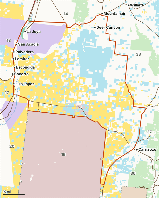
BLMState trust landWildlife Commission landNational wildlife refugeBureau of ReclamationNational Park ServiceMilitary landUnit 18Neighboring unitsLake or riverHighway
| Quadrant | Southwest New Mexico |
|---|---|
| Size | 1,564,967 acres (2,445 square miles) |
| Public land | 65.9% (1,031,695 acres) |
| Military land | 11,676 acres (0.7%), closed except NMDOW's listed hunts |
| Elk hunt codes, 2026-27 | 3 (60 draw licenses) |
| Deer hunt codes, 2026-27 | 5 (305 draw licenses) |
| Pronghorn hunt codes, 2026-27 | 3 (55 draw licenses) |
| Commission land | La Joya WMA (3,647 acres), Bernardo WMA (692 acres) and Socorro-Escondida WMA (107 acres) |
| Towns in and near it | Deer Canyon, Lemitar, Polvadera, Mountainair, Socorro and Carrizozo |
How much public land is in Unit 18?
65.9% of Unit 18 is public land open to hunting under its manager's rules: 1,031,695 of 1,564,967 acres. The largest share is BLM, 531,498 acres or 34% of the unit.
| Manager | Acres | Share of Unit 18 |
|---|---|---|
| BLM | 531,498 | 34% |
| State trust land | 355,241 | 22.7% |
| National wildlife refuge | 140,511 | 9% |
| Military land | 11,676 | 0.7% |
| Wildlife Commission land | 4,425 | 0.3% |
| National Park Service | 595 | under 0.1% |
| Bureau of Reclamation | 20 | under 0.1% |
Measured by FilledTag inside NMDOW's unit boundary from the BLM New Mexico surface management agency map (read 2026-10). Land not listed is private or unmapped. Many state trust land sections touch no public road. NMDOW requires a Habitat Stamp on national forest and BLM land (2026-27 booklet, page 14). National Park Service land is not counted as public here: it is closed to hunting.
State Wildlife Commission land in Unit 18: La Joya WMA (3,647 acres), Bernardo WMA (692 acres) and Socorro-Escondida WMA (107 acres).
Open Gate properties in Unit 18: Rhodes Property (dove, quail, pheasant, spring turkey, sandhill crane, waterfowl, deer (archery only)). Source: NMDOW Open Gate table (updated 09-15-2026).
What can you hunt in Unit 18?
11 hunt codes in NMDOW's 2026-27 booklet are valid in Unit 18. Some cover neighboring units too; each species page lists them all with their recent results.
| Species | Hunt codes | Draw licenses | Season span, 2026-27 | Harvest, newest NMDGF unit total |
|---|---|---|---|---|
| Elk | 3 | 60 | Sep 1 to Oct 5 | 46 (2025-26) |
| Deer | 5 | 305 | Sep 1 to Jan 15 | 81 (2025-26) |
| Pronghorn | 3 | 55 | Aug 15 to Sep 28 | 56 (2025-26) |
Hunts: NMDOW 2026-27 Hunting Rules and Information, pages 58, 84 and 100. Harvest: NMDOW elk harvest reports, NMDOW deer harvest reports and NMDOW pronghorn harvest reports; "with other units" means NMDGF prints this unit's total together with other units.
How do you get to Unit 18?
Highways through the unit: US 85 (about 66 miles inside it), I-25 (about 66 miles inside it), US 60 (about 59 miles inside it), US 380 (about 50 miles inside it) and US 54 (about 21 miles inside it). Towns and places inside: Deer Canyon, Lemitar, Polvadera, La Joya, San Acacia and Luis Lopez. Nearby: Mountainair (on the line), Socorro (on the line), Carrizozo (on the line) and Willard (11 miles).
Which units border Unit 18?
Unit 18 touches 8 other units. Their size, public land and 2026-27 hunt codes, for comparison:
| Unit | Square miles | Public land | Elk codes | Deer codes | Pronghorn codes |
|---|---|---|---|---|---|
| Unit 13 | 4,450 | 41.6% | 10 | 6 | 5 |
| Unit 14 | 1,656 | 17% | 1 | 4 | 4 |
| Unit 17 | 1,648 | 73.8% | 11 | 6 | 6 |
| Unit 19 | 4,247 | 6.7% | 4 | 1 | |
| Unit 20 | 2,550 | 62.9% | 5 | 3 | |
| Unit 36 | 992 | 53.1% | 10 | 7 | 6 |
| Unit 37 | 1,647 | 38.8% | 6 | 5 | 6 |
| Unit 38 | 3,257 | 31.9% | 2 | 5 | 6 |
Questions hunters ask
How much public land is in Unit 18?
65.9% of Unit 18, 1,031,695 of its 1,564,967 acres, is national forest, BLM, state trust, Commission, refuge or Reclamation land, measured by FilledTag from the BLM's New Mexico land status map. The largest share is BLM (531,498 acres).
What can you hunt in Unit 18?
NMDOW's 2026-27 Hunting Rules and Information lists 3 elk, 5 deer and 3 pronghorn hunt codes valid in Unit 18. 11 of them are drawn hunts with 420 licenses in all.
What is the closest town to Unit 18?
Deer Canyon, Lemitar and Polvadera are inside the unit. Just outside: Mountainair (on the line), Socorro (on the line) and Carrizozo (on the line).
Is there Commission or Open Gate land in Unit 18?
NMDOW's Commission land map shows La Joya (3,647 acres here), Bernardo (692 acres here) and Socorro-Escondida (107 acres here) in Unit 18. Open Gate: Rhodes Property (dove, quail, pheasant, spring turkey, sandhill crane, waterfowl, deer (archery only)). Commission lands are closed to hunting unless NMDOW's booklet lists them as open (NMDOW 2026-27 Hunting Rules and Information, page 49).
New Mexico hunting Southwest New Mexico Elk Deer Pronghorn Unit 13 Unit 14 Unit 17 Unit 19 Unit 20 Unit 36 Unit 37 Unit 38