Kansas Deer Management Unit 5: deer harvest, public land and walk-in access
Kansas's Deer Management Unit 5 covers 3,393 square miles across Pawnee, Barton, Stafford, Ness, Rush and Rice counties. 1.9% of it is public land by USGS PAD-US 4.1 and KDWP area maps, mostly national wildlife refuge or WPA, and KDWP's 2026-27 WIHA map adds 25,072 acres of private walk-in land on 117 tracts. KDWP's harvest table shows 3,096 deer taken here in 2021: 1,668 white-tailed bucks, 1,419 antlerless whitetails, 9 mule deer bucks and 0 antlerless mule deer.
Data updated October 2026. Harvest: KDWP's table by unit, 2017 to 2021. Seasons: KDWP's Fall 2026-Spring 2027 summary. Land: USGS PAD-US 4.1 and agency area maps. Walk-in: KDWP, 2026-27.
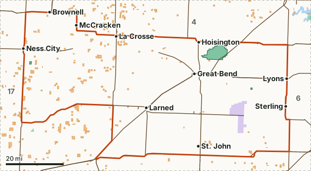
KDWP landNational wildlife refuge or WPAState park or recreation areaOther publicWalk-in (WIHA)Unit 5Wildlife areaNeighboring unitsLakeHighway
| Size | 2,171,215 acres (3,393 square miles) |
|---|---|
| Counties | Pawnee, Barton, Stafford, Ness, Rush, Rice, Reno and Hodgeman and 1 more |
| Public land | 1.9% (41,866 acres) |
| Walk-in land (WIHA, 2026-27) | 25,072 acres on 117 tracts (1.2% of the unit) |
| Deer harvested, 2021 | 3,096 (1,677 bucks) |
| Nonresident whitetail permits, 2026 | 679 (increased by 20 from 659 in 2025) |
| Wildlife areas with a page | Cheyenne Bottoms Wildlife Area, Goodman State Fishing Lake and Wildlife Area and Binger Wildlife Area |
| Towns in it | Great Bend, Lyons, Larned, St. John, Ness City and Ellinwood |
How many deer are harvested in Unit 5?
KDWP's table counts 3,096 deer in 2021, down 1% from 3,141 in 2017. White-tailed deer were 99.7% of the 2021 harvest, and nonresident hunters took 909 of the 3,096 deer (29.4%).
| Year | Total deer | White-tailed bucks | Antlerless whitetails | Mule deer bucks | Antlerless mule deer | Taken by residents | Taken by nonresidents |
|---|---|---|---|---|---|---|---|
| 2021 | 3,096 | 1,668 | 1,419 | 9 | 0 | 2,187 | 909 |
| 2020 | 2,912 | 1,407 | 1,505 | 0 | 0 | 2,115 | 797 |
| 2019 | 2,739 | 1,325 | 1,404 | 5 | 5 | 1,895 | 844 |
| 2018 | 3,056 | 1,432 | 1,618 | 6 | 0 | 2,079 | 977 |
| 2017 | 3,141 | 1,508 | 1,601 | 24 | 8 | 2,246 | 895 |
Source: KDWP deer harvest by unit (2017 to 2021). KDWP's newer harvest reports give statewide totals only, so 2021 is the latest year by unit. Antlerless means does and fawns, as KDWP's table counts them.
How much public land is in Unit 5?
1.9% of the unit is public land: 41,866 of its 2,171,215 acres, led by national wildlife refuge or WPA at 22,286 acres. Wildlife areas with a page of their own: Cheyenne Bottoms Wildlife Area, Goodman State Fishing Lake and Wildlife Area and Binger Wildlife Area.
| Manager | Acres | Share of the unit |
|---|---|---|
| National wildlife refuge or WPA | 22,286 | 1% |
| KDWP land | 19,580 | 0.9% |
| Other public (not counted as hunting land) | 415 | under 0.1% |
| State park or recreation area (not counted as hunting land) | 4 | under 0.1% |
Measured by FilledTag inside KDWP's unit boundary from USGS PAD-US 4.1 (fee and designation lands with open or restricted public access) and KDWP wildlife areas; the water of the larger reservoirs is left out.
How much walk-in hunting land is in Unit 5?
KDWP's 2026-27 Walk-In Hunting Access layer maps 25,072 acres on 117 tracts inside the unit, 1.2% of its ground. WIHA land is private land KDWP leases for walk-in hunting during the lease period on its sign. County totals for the counties the unit touches:
| County | Share of the county in this unit | WIHA acres in the county | WIHA tracts in the county |
|---|---|---|---|
| Pawnee County | 85.6% | 5,594 | 23 |
| Barton County | 61.3% | 974 | 9 |
| Stafford County | 65.8% | 1,983 | 13 |
| Ness County | 41.3% | 16,025 | 64 |
| Rush County | 56.4% | 19,674 | 95 |
| Rice County | 48.9% | 0 | 0 |
| Reno County | 16.8% | 4,960 | 39 |
| Hodgeman County | 20.2% | 26,340 | 89 |
| Edwards County | 12.7% | 12,491 | 24 |
Walk-in acres inside the unit measured by FilledTag from KDWP Walk-In Hunting Access (WIHA) tracts; county acres and tract counts are KDWP's own figures for each tract.
When is deer season in Unit 5 in 2026?
The statewide seasons apply here, plus an extended firearm season for antlerless whitetails, Jan. 1-17, 2027. Up to five Whitetail Antlerless-only permits can be used here: the first anywhere in the unit (public land and walk-in included), permits 2 to 5 only on private land with permission, walk-in areas, Fort Leavenworth (Unit 10A), and Elk City and Berentz-Dick wildlife areas.
| Season, 2026-27 | Dates |
|---|---|
| Youth (17 and younger) and disabled | Sept. 5-13, 2026 |
| Muzzleloader | Sept. 14-27, 2026 |
| Archery | Sept. 14-Dec. 31, 2026 |
| Pre-rut whitetail antlerless firearm | Oct. 10-12, 2026 |
| Regular firearm | Dec. 2-13, 2026 |
| Extended firearm whitetail antlerless-only (Unit 5) | Jan. 1-17, 2027 |
Source: KDWP's Fall 2026-Spring 2027 Hunting & Furharvesting Regulations Summary, page 30; Whitetail Antlerless-only permits, page 33.
How many nonresident deer permits does Unit 5 get?
KDWP authorized 679 nonresident whitetail either-sex permits for Unit 5 in 2026 (increased by 20 from 659 in 2025). 944 hunters picked the unit as their first choice, and 374 permits went to applicants with no preference points.
| Draw | Permits | First-choice applications | Second choice | Permits to 0-point applicants | Permits to 1-point applicants |
|---|---|---|---|---|---|
| 2026 | 679 | 944 | 1,050 | 374 | 284 |
| 2025 | 659 | 1,030 | 959 | 341 | 290 |
Source: KDWP deer quotas and draw statistics. Nonresident permits are drawn for one unit plus one adjacent unit (KDWP's Fall 2026-Spring 2027 Hunting & Furharvesting Regulations Summary, page 32). Residents buy whitetail permits over the counter; resident either-species firearm permits are drawn by zone.
Is there elk or pronghorn hunting in Unit 5?
KDWP's elk unit map overlaps it: elk unit 3. No pronghorn unit overlaps it. Elk and pronghorn permits are for residents, except pronghorn archery permits, which nonresidents can buy too.
Units: KDWP elk units; KDWP pronghorn firearm units. Rules: KDWP's Fall 2026-Spring 2027 Hunting & Furharvesting Regulations Summary, page 36 to 38.
Which deer units border Unit 5?
Unit 5 touches 6 other units. Their public land, walk-in acres and 2021 harvest, for comparison:
| Unit | Public land | WIHA acres | Deer harvested, 2021 |
|---|---|---|---|
| Unit 2 | 0.3% | 157,235 | 1,540 |
| Unit 4 | 1.1% | 29,342 | 2,752 |
| Unit 6 | 0.7% | 5,644 | 2,888 |
| Unit 15 | 0.3% | 6,628 | 6,569 |
| Unit 16 | 0.3% | 24,639 | 3,218 |
| Unit 17 | 0.1% | 117,037 | 2,405 |
Questions hunters ask
How much public land is in Kansas deer Unit 5?
41,866 acres, 1.9% of the unit, by USGS PAD-US 4.1 and KDWP area maps; the largest share is national wildlife refuge or WPA (22,286 acres). KDWP's walk-in program adds 25,072 acres of private land open to walk-in hunting in 2026-27.
How many deer were harvested in Unit 5 in the latest year on record?
3,096 in 2021, KDWP's latest year by unit: 1,668 white-tailed bucks, 1,419 antlerless whitetails, 9 mule deer bucks and 0 antlerless mule deer.
Can a nonresident hunt deer in Kansas Unit 5?
Yes, with a permit drawn in April. KDWP set 679 nonresident whitetail permits for Unit 5 in 2026; each is valid in the unit drawn and one adjacent unit. The application deadline is the last Friday in April.
Which counties are in Unit 5?
Pawnee, Barton, Stafford, Ness, Rush, Rice, Reno, Hodgeman and Edwards. Walk-in land by county is on each county's WIHA page where one exists.
Get a Kansas hunt plan when they open
Hunt plans for Kansas are coming. Join the list and you'll hear first. The first 50 hunters in each new state get their plan free.
Until then, the free FilledTag app for iPhone has a map that works in every state, Kansas included.
Where these numbers come from
- Harvest: KDWP deer harvest by unit (2017 to 2021).
- Seasons, permits and rules: KDWP's Fall 2026-Spring 2027 Hunting & Furharvesting Regulations Summary; KDWP deer quotas and draw statistics.
- Public land: USGS PAD-US 4.1. Walk-in land: KDWP Walk-In Hunting Access (WIHA) tracts. Unit boundary: KDWP Deer Management Units.
- Highways and towns: U.S. Census Bureau TIGER/Line 2024 primary and secondary roads; U.S. Census Bureau 2024 Gazetteer, places.
FilledTag is not part of Kansas Department of Wildlife and Parks. Numbers are copied from KDWP, the USGS and the Census Bureau, or measured from their maps; nothing on this page is estimated by FilledTag.
Kansas hunting Walk-in hunting by county Unit 2 Unit 4 Unit 6 Unit 15 Unit 16 Unit 17