Kansas walk-in hunting (WIHA) by county: 2026-27 tracts and acres
KDWP's 2026-27 Walk-In Hunting Access map has 952,949 acres on 3,559 tracts in 98 of Kansas's 105 counties. Cheyenne County has the most, 45,054 acres. WIHA tracts are private land KDWP leases for walk-in hunting during the lease period on each sign.
Data updated October 2026. Walk-in: KDWP, 2026-27.
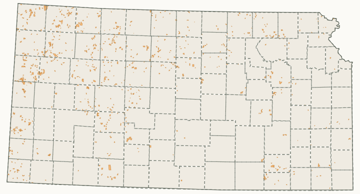
How much WIHA land does each county have?
| County | Acres | Tracts | Share of the county | Deer units |
|---|---|---|---|---|
| Cheyenne County | 45,054 | 82 | 6.9% | Unit 1 |
| Wallace County | 44,053 | 96 | 7.5% | Unit 2 |
| Rawlins County | 37,681 | 96 | 5.5% | Unit 1 |
| Hamilton County | 33,613 | 117 | 5.3% | Unit 17 |
| Thomas County | 32,327 | 98 | 4.7% | Unit 1 and Unit 2 |
| Graham County | 29,209 | 111 | 5.1% | Unit 1 and Unit 3 |
| Hodgeman County | 26,340 | 89 | 4.8% | Unit 17 and Unit 5 |
| Marshall County | 24,752 | 144 | 4.3% | Unit 9 and Unit 8 |
| Morton County | 23,761 | 116 | 5.1% | Unit 18 |
| Trego County | 23,735 | 93 | 4.1% | Unit 2, Unit 3, Unit 4 and Unit 1 |
| Gove County | 23,266 | 58 | 3.4% | Unit 2 and Unit 1 |
| Decatur County | 22,913 | 41 | 4% | Unit 1 |
| Osborne County | 20,866 | 82 | 3.6% | Unit 3 and Unit 7 |
| Clark County | 20,090 | 24 | 3.2% | Unit 16, Unit 18 and Unit 17 |
| Rush County | 19,674 | 95 | 4.3% | Unit 5 and Unit 4 |
| Logan County | 19,583 | 47 | 2.9% | Unit 2 |
| Sherman County | 19,535 | 49 | 2.9% | Unit 1 and Unit 2 |
| Sheridan County | 19,325 | 63 | 3.4% | Unit 1 |
| Lane County | 18,462 | 80 | 4% | Unit 17 and Unit 2 |
| Ellis County | 18,222 | 69 | 3.2% | Unit 3 and Unit 4 |
| Greeley County | 16,648 | 50 | 3.3% | Unit 2 and Unit 17 |
| Rooks County | 16,061 | 57 | 2.8% | Unit 3 |
| Ness County | 16,025 | 64 | 2.3% | Unit 17, Unit 5, Unit 2 and Unit 4 |
| Washington County | 15,647 | 82 | 2.7% | Unit 8 |
| Russell County | 15,514 | 59 | 2.7% | Unit 7, Unit 4 and Unit 3 |
| Stanton County | 15,430 | 69 | 3.5% | Unit 17 and Unit 18 |
| Norton County | 14,404 | 52 | 2.6% | Unit 1 and Unit 3 |
| Smith County | 14,219 | 76 | 2.5% | Unit 7 and Unit 3 |
| Lincoln County | 13,004 | 40 | 2.8% | Unit 7 and Unit 4 |
| Wabaunsee County | 12,708 | 32 | 2.5% | Unit 14 and Unit 9 |
| Edwards County | 12,491 | 24 | 3.1% | Unit 16, Unit 17 and Unit 5 |
| Elk County | 12,207 | 35 | 2.9% | Unit 12 and Unit 14 |
| Jewell County | 11,753 | 64 | 2% | Unit 7 |
| Cloud County | 11,539 | 56 | 2.5% | Unit 8 and Unit 7 |
| Nemaha County | 11,456 | 70 | 2.5% | Unit 9 |
| Mitchell County | 9,924 | 50 | 2.2% | Unit 7 |
| Dickinson County | 8,263 | 38 | 1.5% | Unit 8, Unit 6 and Unit 14 |
| Ford County | 7,692 | 37 | 1.1% | Unit 17, Unit 18 and Unit 16 |
| Saline County | 7,528 | 24 | 1.6% | Unit 4, Unit 8, Unit 6 and Unit 7 |
| Grant County | 7,484 | 34 | 2% | Unit 18 and Unit 17 |
| Chautauqua County | 7,394 | 22 | 1.8% | Unit 12 |
| Lyon County | 7,159 | 28 | 1.3% | Unit 14 |
| Brown County | 7,133 | 41 | 1.9% | Unit 10 and Unit 9 |
| Labette County | 6,983 | 40 | 1.7% | Unit 11 |
| Neosho County | 6,585 | 32 | 1.8% | Unit 11 and Unit 12 |
| Clay County | 6,338 | 33 | 1.5% | Unit 8 |
| Chase County | 6,325 | 7 | 1.3% | Unit 14 |
| Phillips County | 6,256 | 24 | 1.1% | Unit 3 |
| Ottawa County | 6,226 | 34 | 1.3% | Unit 8 and Unit 7 |
| Doniphan County | 6,155 | 35 | 2.4% | Unit 10 |
| Pratt County | 6,131 | 14 | 1.3% | Unit 16 and Unit 15 |
| Pottawatomie County | 5,807 | 31 | 1.1% | Unit 9 |
| Pawnee County | 5,594 | 23 | 1.2% | Unit 5 and Unit 17 |
| Stevens County | 5,414 | 37 | 1.2% | Unit 18 |
| Finney County | 5,362 | 23 | 0.6% | Unit 17 |
| Republic County | 5,221 | 36 | 1.1% | Unit 7 and Unit 8 |
| Reno County | 4,960 | 39 | 0.6% | Unit 15, Unit 6 and Unit 5 |
| Kiowa County | 4,106 | 23 | 0.9% | Unit 16 and Unit 17 |
| Seward County | 4,077 | 27 | 1% | Unit 18 |
| Jackson County | 3,997 | 23 | 0.9% | Unit 9 and Unit 10 |
| Atchison County | 3,886 | 13 | 1.4% | Unit 10 |
| Butler County | 3,790 | 7 | 0.4% | Unit 14 and Unit 15 |
| Ellsworth County | 3,679 | 20 | 0.8% | Unit 4, Unit 7 and Unit 6 |
| Osage County | 3,274 | 16 | 0.7% | Unit 14, Unit 10 and Unit 11 |
| Meade County | 2,889 | 15 | 0.5% | Unit 18 |
| Anderson County | 2,664 | 15 | 0.7% | Unit 11 |
| Gray County | 2,604 | 15 | 0.5% | Unit 17 and Unit 18 |
| Greenwood County | 2,520 | 7 | 0.3% | Unit 14 and Unit 12 |
| Wichita County | 2,468 | 13 | 0.5% | Unit 2 and Unit 17 |
| Bourbon County | 2,433 | 15 | 0.6% | Unit 11 |
| Kearny County | 2,362 | 13 | 0.4% | Unit 17 |
| Coffey County | 2,310 | 15 | 0.6% | Unit 11 and Unit 14 |
| Scott County | 2,240 | 1 | 0.5% | Unit 17 and Unit 2 |
| Shawnee County | 2,195 | 18 | 0.6% | Unit 10, Unit 9 and Unit 14 |
| Morris County | 2,186 | 16 | 0.5% | Unit 14 and Unit 8 |
| Stafford County | 1,983 | 13 | 0.4% | Unit 5, Unit 16 and Unit 15 |
| Linn County | 1,907 | 8 | 0.5% | Unit 11 |
| Kingman County | 1,554 | 13 | 0.3% | Unit 15 and Unit 16 |
| Allen County | 1,535 | 7 | 0.5% | Unit 11 |
| Leavenworth County | 1,481 | 8 | 0.5% | Unit 10 |
| Jefferson County | 1,462 | 12 | 0.4% | Unit 10 |
| Montgomery County | 1,427 | 7 | 0.3% | Unit 12 and Unit 11 |
| Geary County | 1,351 | 4 | 0.5% | Unit 14, Unit 8 and Unit 9 |
| Cowley County | 1,320 | 4 | 0.2% | Unit 13, Unit 14, Unit 12 and Unit 15 |
| Crawford County | 1,189 | 6 | 0.3% | Unit 11 |
| Harper County | 1,186 | 4 | 0.2% | Unit 16 and Unit 15 |
| Barton County | 974 | 9 | 0.2% | Unit 5 and Unit 4 |
| Riley County | 817 | 8 | 0.2% | Unit 8, Unit 9 and Unit 14 |
| Haskell County | 800 | 5 | 0.2% | Unit 18 and Unit 17 |
| Woodson County | 753 | 2 | 0.2% | Unit 11, Unit 14 and Unit 12 |
| McPherson County | 524 | 4 | 0.1% | Unit 6 and Unit 4 |
| Harvey County | 467 | 2 | 0.1% | Unit 15 and Unit 6 |
| Cherokee County | 353 | 2 | 0.1% | Unit 11 |
| Sumner County | 316 | 3 | under 0.1% | Unit 15 and Unit 13 |
| Comanche County | 160 | 1 | under 0.1% | Unit 16 |
| Johnson County | 80 | 1 | under 0.1% | Unit 10 and Unit 11 |
| Wilson County | 80 | 1 | under 0.1% | Unit 12 and Unit 11 |
| Douglas County | 49 | 1 | under 0.1% | Unit 10 |
Source: KDWP Walk-In Hunting Access (WIHA) tracts. Counties with a link have a page of their own (three or more tracts and 300 acres, or one tract of 1,500 acres or more).
Questions hunters ask
Which Kansas county has the most WIHA land?
Cheyenne County with 45,054 acres on 82 tracts, then Wallace (44,053), Rawlins (37,681) and Hamilton (33,613).
How much WIHA land is there in Kansas?
952,949 acres on 3,559 tracts in 98 counties on KDWP's 2026-27 map.
Get a Kansas hunt plan when they open
Hunt plans for Kansas are coming. Join the list and you'll hear first. The first 50 hunters in each new state get their plan free.
Until then, the free FilledTag app for iPhone has a map that works in every state, Kansas included.
Sources: KDWP Walk-In Hunting Access (WIHA) tracts; KDWP's Fall 2026-Spring 2027 Hunting & Furharvesting Regulations Summary, page 56. FilledTag is not part of Kansas Department of Wildlife and Parks.