Steptoe Valley Wildlife Management Area: hunting rules and map
Steptoe Valley Wildlife Management Area is 6,426 acres in White Pine County, managed by NDOW in its Eastern Region and inside hunt units 111 and 222. NDOW lists hunting on the area, with this rule first: the use or possession of shells for a shotgun containing shot that is toxic or larger than standard-sized T is prohibited in the Meadow Unit.
Data updated October 2026. Area rules: NDOW's public land page, read 2026-10-18. Boundary and acres: NDOW GIS. Land around it: BLM.
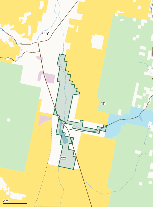
BLMNational forestState landTribal landSteptoe Valley WMAHunt unit lineLake or riverHighway
| Size | 6,426 acres (NDOW legal acres); NDOW's area page gives 20,000 |
|---|---|
| County | White Pine County |
| NDOW region | Eastern Region |
| Hunt units | 111, 222 |
| Status in NDOW's map | Designated |
| Camping | Not permitted in the Meadow Unit. Camping is permitted in designated campsites in the Mountain Unit. Camping is also permitted in any site on the Mountain Unit that is more than 0.5 miles from the Success Summit Road. |
| Nearest towns | Ely (2 mi), Ruth (8 mi) and McGill (11 mi) |
What is Steptoe Valley WMA?
The Steptoe Valley Wildlife Management Area (SVWMA) is located in White Pine County near Ely. The property consists of two management units (Mountain Unit and Meadow Unit) and comprises nearly 20,000 acres.
In NDOW's words, from NDOW's public land page.
What are the rules on Steptoe Valley WMA?
| Topic | NDOW's rule |
|---|---|
| Hunting | The use or possession of shells for a shotgun containing shot that is toxic or larger than standard-sized T is prohibited in the Meadow Unit. |
| Camping | Not permitted in the Meadow Unit. Camping is permitted in designated campsites in the Mountain Unit. Camping is also permitted in any site on the Mountain Unit that is more than 0.5 miles from the Success Summit Road. |
| Campfires | Not permitted in the Meadow Unit. Campfires are permitted in the Mountain Unit (Subject to fire restrictions issued by State or Federal Agencies, |
| Trespass and travel | No restrictions: Stay on existing roads. |
| Boats | Comins Lake Water skiing only allowed between 11 a.m. and sunset. Flat wake restrictions in effect for boats during other hours |
| Trapping | Permitted on first come, first serve basis and may contain designation of specific trapping areas, dates or other restrictions to ensure compatibility with other public actives. |
| Bodies of water | Comins Lake, |
Source: NDOW, Your Public Land. Big game seasons on the area follow the hunt unit's regulations.
Which big game unit groups take in Steptoe Valley WMA?
NDOW draws big game tags by unit group. The groups that include units 111 and 222, with NDOW's 2025 figures for the whole group, not the WMA alone:
| Species and group | Tags issued, 2025 | Successful hunters, 2025 |
|---|---|---|
| Pronghorn antelope, 111 - 114 | 121 | 86 |
| Pronghorn antelope, 221 - 223, 241 | 47 | 33 |
| Mule deer, 111 - 113 | 316 | 143 |
| Mule deer, 221 - 223 | 125 | 40 |
| Elk, 111 - 115 | 186 | 113 |
| Elk, 221 - 223 | 202 | 99 |
Source: NDOW Big Game Hunt Statistics (2022 to 2025; 2025 from NDOW's 2025 hunt data workbook).
What land surrounds Steptoe Valley WMA?
Inside the WMA boundary, BLM's surface management map shows BLM 2 acres. NDOW's WMA map records its status as designated. Highways within 8 miles: US 93, US 50, US 6 and NV 486. Nearest towns: Ely (2 miles), Ruth (8 miles), McGill (11 miles) and Preston (20 miles).
Questions hunters ask
Can you hunt on Steptoe Valley WMA?
Yes. NDOW's rule for hunting on the area: The use or possession of shells for a shotgun containing shot that is toxic or larger than standard-sized T is prohibited in the Meadow Unit.
Can you camp on Steptoe Valley WMA?
NDOW lists camping as: Not permitted in the Meadow Unit. Camping is permitted in designated campsites in the Mountain Unit. Camping is also permitted in any site on the Mountain Unit that is more than 0.5 miles from the Success Summit Road.
Which hunt unit is Steptoe Valley WMA in?
By NDOW's boundaries: unit 111 (4,424 acres) and unit 222 (2,065 acres).
Where is Steptoe Valley WMA?
The Steptoe Valley Wildlife Management Area (SVWMA) is located in White Pine County near Ely. The nearest town by the census map is Ely, 2 miles away.
Get a Nevada hunt plan when they open
Hunt plans for Nevada are coming. Join the list and you'll hear first. The first 50 hunters in each new state get their plan free.
Until then, the free FilledTag app for iPhone has a map that works in every state, Nevada included.
Where these facts come from
- Description and rules: NDOW, Your Public Land.
- Boundary, acres and status: NDOW wildlife management areas. Surrounding land: BLM Surface Management Agency map (national, limited scale).
- Unit group figures: NDOW Big Game Hunt Statistics (2022 to 2025; 2025 from NDOW's 2025 hunt data workbook).
FilledTag is not part of the Nevada Department of Wildlife.
Nevada hunting Eastern Region Pronghorn antelope 111 - 114 Pronghorn antelope 221 - 223, 241 Mule deer 111 - 113 Mule deer 221 - 223 Elk 111 - 115 Elk 221 - 223