Pinetop region (AZGFD Region 1): hunting units, land and hunts
AZGFD's Region 1, run from Pinetop, covers the White Mountains and east-central Arizona: 10 game management units, 57.8% of it public land open to hunting (USGS PAD-US). AZGFD's 2026 booklets list 5,527 elk permits and 2,505 deer permits on hunts that include its units.
Data updated October 2026. Hunts: AZGFD's 2026 booklets. Land: USGS PAD-US 4.1. Units: AZGFD.
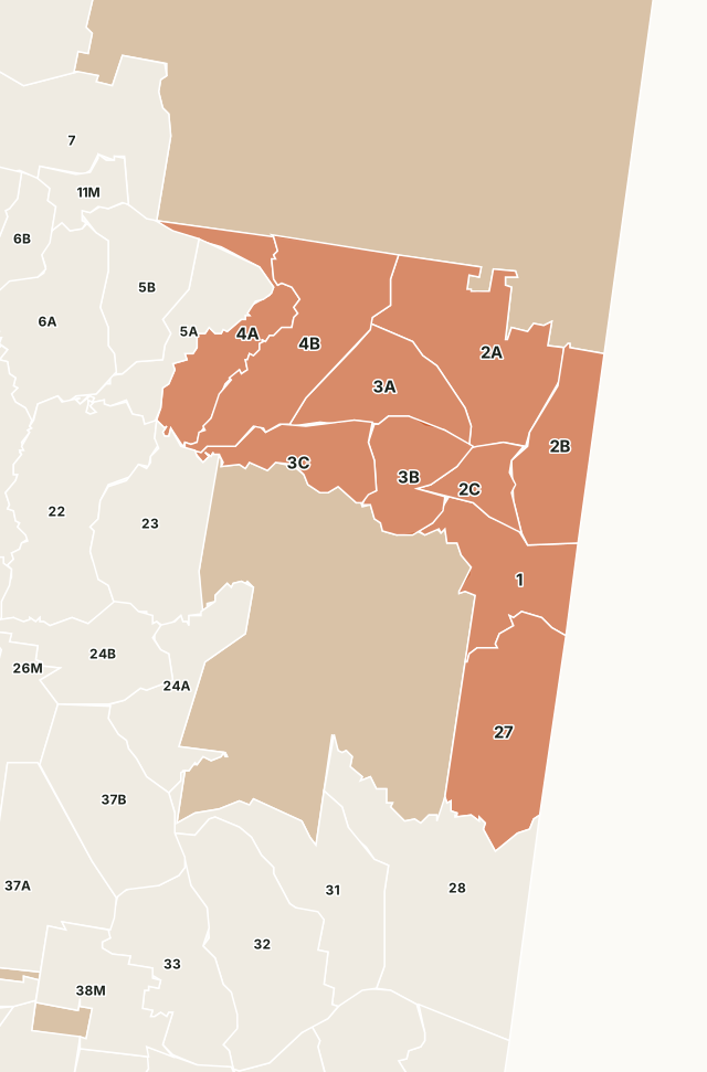
The Pinetop region holds the White Mountains and the high plateau around Show Low, Springerville, Eagar and St. Johns, much of it in the Apache-Sitgreaves National Forests. The Fort Apache Indian Reservation borders it, and tribal land is outside AZGFD's units.
Which units are in Region 1?
All 10 units AZGFD's boundary layer puts first in Region 1, with their public land and the number of 2026 draw hunts that include each. The most public land: Unit 27 (94.6%), Unit 1 (91.1%) and Unit 3C (82.3%). The most elk hunts: Unit 1 (20), Unit 2B (13) and Unit 3B (13).
| Unit | Square miles | Public land | Largest manager | Elk hunts | Deer hunts | Pronghorn hunts |
|---|---|---|---|---|---|---|
| Unit 1 | 844 | 91.1% | National forest | 20 | 2 | 2 |
| Unit 2A | 1,423 | 29.8% | State trust land | 6 | 1 | 1 |
| Unit 2B | 824 | 56.7% | State trust land | 13 | 1 | 1 |
| Unit 2C | 315 | 59.2% | State trust land | 8 | 1 | 1 |
| Unit 3A | 773 | 29.6% | State trust land | 7 | 3 | 2 |
| Unit 3B | 579 | 44.5% | National forest | 13 | 2 | 2 |
| Unit 3C | 555 | 82.3% | National forest | 12 | 3 | 1 |
| Unit 4A | 754 | 62.7% | National forest | 7 | 1 | 2 |
| Unit 4B | 1,335 | 38.9% | National forest | 7 | 1 | 2 |
| Unit 27 | 1,353 | 94.6% | National forest | 10 | 6 |
Hunts: AZGFD's 2026 booklets; a hunt that covers several units counts in each. Land measured by FilledTag inside AZGFD's unit boundaries from USGS PAD-US 4.1 (fee managers).
How much public land is in Region 1?
| Manager | Acres | Share of the region |
|---|---|---|
| National forest | 1,998,642 | 35.7% |
| State trust land | 1,036,163 | 18.5% |
| Tribal land (tribal permit) | 209,979 | 3.7% |
| BLM | 197,340 | 3.5% |
| National park or monument (no hunting) | 147,711 | 2.6% |
| AZGFD land | 8,350 | 0.1% |
| City, county and other | 2,221 | under 0.1% |
Public land open to hunting here means national forest, BLM, state trust land, AZGFD land, national wildlife refuges, national recreation areas and Bureau of Reclamation land. Tribal land, military land and national parks are counted on their own rows and left out of that figure.
AZGFD wildlife areas in Region 1
- Allen Severson Memorial Wildlife Area: 360 acres
- Becker Lake Wildlife Area: 537 acres
- Bog Hole Wildlife Area: 197 acres
- Chevelon Canyon Ranch Wildlife Area: 137 acres
- Chevelon Creek Wildlife Area: 673 acres
- Fool Hollow Lake Wildlife Area: 90 acres
- Jaques Marsh Wildlife Area: 221 acres
- Luna Lake Wildlife Area: 116 acres
- Sipe White Mountain Wildlife Area: 1,365 acres
- Wenima Wildlife Area: 354 acres
- White Mountain Grasslands Wildlife Area: 2,860 acres
Get Arizona updates from FilledTag
Join the Arizona list and FilledTag will email you when it adds more for Arizona hunters.
The free FilledTag app for iPhone has a map that works in every state, Arizona included.
Sources: AZGFD's 2026 Pronghorn and Elk booklet and 2026-27 regulations; USGS PAD-US 4.1 (fee managers); AZGFD game management unit boundaries; AZGFD wildlife areas. FilledTag is not part of the Arizona Game and Fish Department.
Arizona hunting Region 2 Region 3 Region 4 Region 5 Region 6