Southeast New Mexico: hunting units, public land and hunts
NMDOW's southeast quadrant holds 13 game management units (28, 29, 30, 31, 32, 33, 34, 35, 36, 37, 38, 39 and 40), 23,427,313 acres of which 43.1% is public land, mostly BLM (BLM New Mexico land status map, 2026). NMDOW's 2026-27 booklet lists 189 hunt codes valid in these units, including 4,050 elk and 11,865 deer draw licenses for hunts inside the quadrant.
Data updated October 2026. Quadrants: NMDOW's 2026-27 booklet, page 52. Hunts: the same booklet. Land: BLM New Mexico, 2026-10.
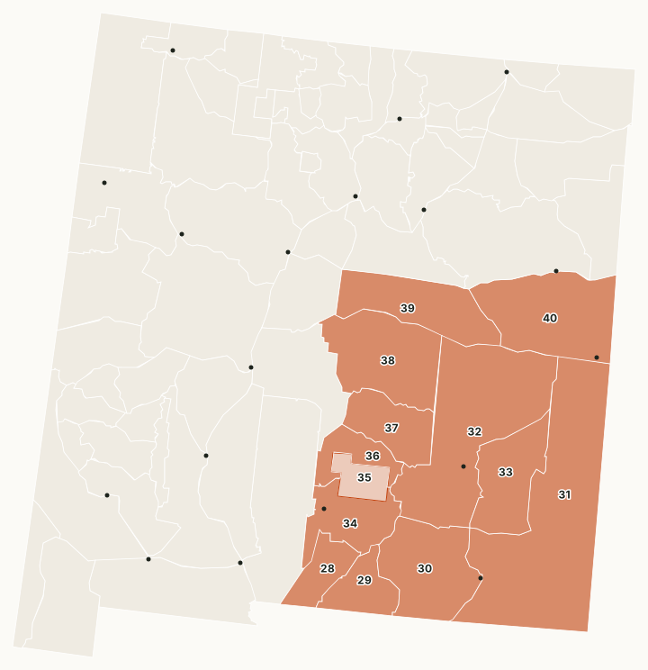
NMDOW's southeast quadrant covers the Sacramento Mountains around Cloudcroft (Unit 34) and the Pecos Valley plains down to Carlsbad (Unit 30). It holds Fort Bliss's McGregor Range (Unit 28), where NMDOW holds oryx and Barbary sheep hunts, more Barbary sheep draw hunts in Units 29 and 30 and in Units 32, 36 and 37, and the Prairie Chicken Areas and the W.S. Huey WMA.
Which units are in Southeast New Mexico?
All 13 units, with public land and the number of 2026-27 hunt codes for each species. The most public land: Unit 28 (89.4%), Unit 29 (84%) and Unit 30 (75.4%). The most elk hunt codes: Unit 34 (14), Unit 36 (10) and Unit 37 (6).
| Unit | Square miles | Public land | Largest public manager | Tribal land | Elk codes | Deer codes | Pronghorn codes | Other big game codes |
|---|---|---|---|---|---|---|---|---|
| Unit 28 | 1,061 | 89.4% | BLM | 2 | 2 | 2 | 10 | |
| Unit 29 | 1,182 | 84% | BLM | 4 | 5 | 3 | 8 | |
| Unit 30 | 2,943 | 75.4% | BLM | 4 | 6 | 1 | 8 | |
| Unit 31 | 8,347 | 48.4% | State trust land | 5 | 12 | |||
| Unit 32 | 6,075 | 33.4% | BLM | 7 | 12 | 8 | ||
| Unit 33 | 2,272 | 57.9% | BLM | 7 | 6 | |||
| Unit 34 | 1,696 | 67.5% | National forest | 14 | 7 | |||
| Unit 35 | 720 | 0% | 99.9% | |||||
| Unit 36 | 992 | 53.1% | National forest | 10 | 7 | 6 | 8 | |
| Unit 37 | 1,647 | 38.8% | National forest | 6 | 5 | 6 | 8 | |
| Unit 38 | 3,257 | 31.9% | State trust land | 2 | 5 | 6 | ||
| Unit 39 | 2,638 | 18.2% | State trust land | 1 | 5 | 6 | ||
| Unit 40 | 3,776 | 10.4% | State trust land | 5 | 4 |
Quadrants: NMDOW 2026-27 Hunting Rules and Information, page 52 (units the booklet does not list are placed by NMDOW's officer districts). Hunts: NMDOW 2026-27 Hunting Rules and Information. Land measured by FilledTag from the BLM New Mexico surface management agency map (read 2026-10).
How much public land is in Southeast New Mexico?
| Manager | Acres | Share of the quadrant |
|---|---|---|
| BLM | 5,057,379 | 21.6% |
| State trust land | 3,720,733 | 15.9% |
| National forest | 1,189,864 | 5.1% |
| Tribal land | 460,130 | 2% |
| Military land | 146,246 | 0.6% |
| Bureau of Reclamation | 57,850 | 0.2% |
| National Park Service | 46,147 | 0.2% |
| Wildlife Commission land | 39,483 | 0.2% |
| National wildlife refuge | 28,738 | 0.1% |
| Other federal (closed) | 11,945 | 0.1% |
| State park | 3,937 | under 0.1% |
Commission lands open to hunting here: Prairie Chicken WMAs (36,633 acres) and W.S. Huey WMA (3,462 acres).
Which species pages cover Southeast New Mexico?
Elk: Unit 28, Units 29 and 30, Unit 34, Unit 36, Unit 37, Unit 38. Deer: Unit 28, Unit 29, Unit 30, Unit 31, Unit 32, Unit 33, Unit 34, Unit 36, Unit 37, Unit 38, Unit 39, Unit 40. Pronghorn: Unit 28, Unit 29, Unit 31, Unit 32, Unit 33, Units 36 and 37, Unit 38, Unit 39, Unit 40. Oryx: Unit 28. Barbary Sheep: Unit 28, Units 29 and 30, Units 32, 36 and 37.
New Mexico hunting Northwest New Mexico Northeast New Mexico Southwest New Mexico