What does the free FilledTag hunting map show?
The FilledTag map is free in all 50 states: public land tinted by the agency that manages it, private property lines in 28 states with the owner on record in 14 of them, hunting units in 48 states (3,624 unit, zone and district shapes from each state agency), Forest Service timber cuts since 2011, wildfire edges since 2000, walk-in and access-program land in 25 states, saved maps for no signal, 77 waypoint types, routes with walking time and climb, National Weather Service wind and legal shooting light. No account is needed to look.
Data updated November 2026. State layers as checked in the app's list of agency map services on November 3, 2026; screenshots of the live browser map taken November 3, 2026.
Download on theApp Store Android app: in testing, join the list Open the map in your browser
Does the map show public land and who manages it?
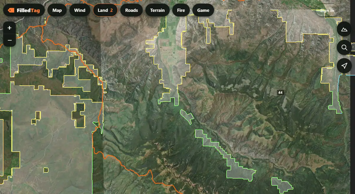
Yes, nationwide. Land ownership tints Bureau of Land Management ground, national forest, state land and the other public managers each in their own color, from the BLM's national Surface Management Agency map. Ground left clear is private or not on record. National forest outer lines (Forest Service) and state lines (Census Bureau) draw on top, since seasons and licenses change at both.
Does it show private property lines and landowner names?
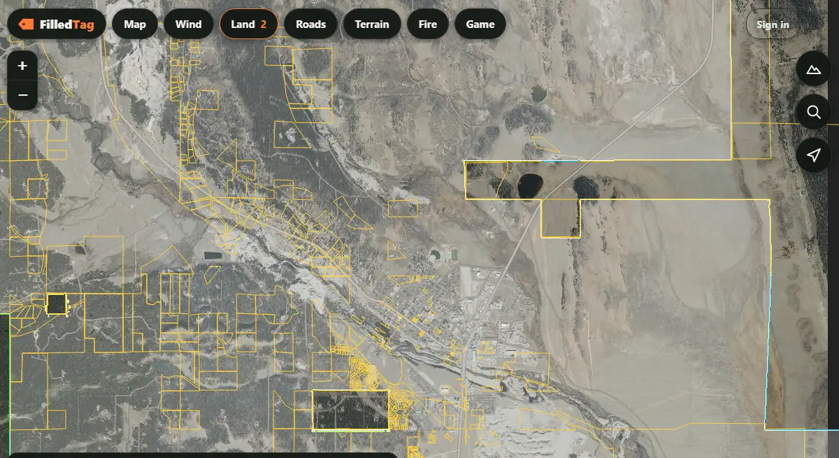
Yes, where the county or state publishes them: parcel lines in 28 states, and the owner's name on record in 14 (Arkansas, Colorado, Connecticut, Idaho, Iowa, Minnesota, Montana, New York, North Carolina, North Dakota, Vermont, West Virginia, Wisconsin and Wyoming). Press and hold inside a parcel for its owner and acres. Some states share lines without names (14 states, among them California, Hawaii, Indiana, Maine, Maryland), and some publish only part of the state: Minnesota, New York, Pennsylvania and Idaho list only the counties that share. Iowa's names come from the state's 2017 snapshot, not this year's roll. A parcel line is a county's record, not a survey: fences, signs and corners on the ground come first.
Does it show hunting units?
Yes, in 48 states, each as its agency draws and names them: Colorado's 186 game management units, Idaho's 99, Montana's 151 deer and elk hunting districts, Minnesota's 130 deer permit areas, and counties where a state sets its seasons by county. Colorado's and Idaho's units are carried inside the app, so they draw with no signal; every other state's are kept on the phone once they have been opened. Tap anywhere for "What is here": the unit you are standing in, the land manager and the elevation. Not drawn yet: Alabama and Maryland. Find your own with the hunting unit finder.
Does it show timber cuts and clearcuts?
Yes, in the iPhone app: "Timber cuts since 2011" shades where the Forest Service has cut or thinned timber, from its own timber harvest records. A cut grows back as brush and young trees, the feed and edge a few years on. Only National Forest land is in that record, so cuts on private and state timber are not shown. Beside it, the "Trees and plants" layer (federal LANDFIRE survey, 30-yard squares) shows dark timber, aspen, oak brush and sagebrush.
Does it show old burns and fire history?
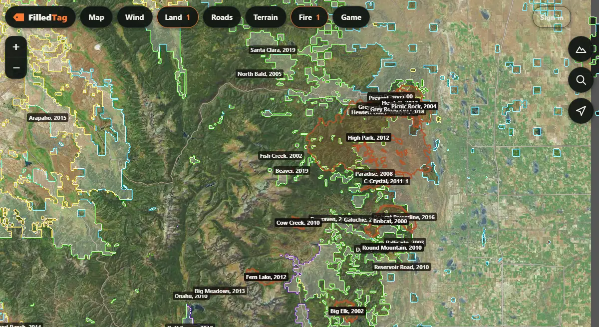
Yes. "Past wildfires" draws the edge of every recorded fire since 2000, each labeled with its name and year, from the National Interagency Fire Center's fire perimeter history, and "Wildfires" shows fires burning now. An old burn grows back as open ground and young timber; a recent one can be closed to entry.
Does it show Walk-In Access and other access-program land?
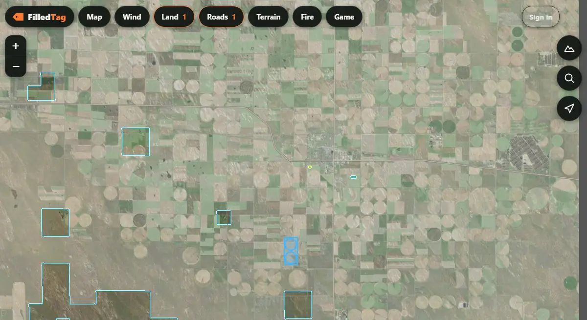
Yes, in 25 states, as each program publishes it: Colorado's Walk-In Access, Kansas WIHA, North Dakota PLOTS, Montana Block Management, Nebraska Open Fields and Waters, Wyoming Walk-In and Hunter Management Areas, Idaho Access Yes!, Michigan HAP, Minnesota Walk-In Access, Oklahoma OLAP, Oregon Access and Habitat, Washington's access programs and more. Each is open only for the species and dates its program lists.
Does it work with no cell signal?
Yes. Save an area before you leave service and the app keeps the aerial photo, topo, land ownership, water, forest roads and contour lines for it on the phone. Your pins, routes, tracks and the hunting units you have opened work with no signal too. The wind forecast and new layers need signal.
How many waypoint types does it have?
77 in the iPhone app (74 on the browser map), in seven groups: hunting (stands, blinds, glassing points), sign (rubs, scrapes, wallows, beds, tracks), animals, ground and water, access (truck, gate, trailhead), mushrooms, and camp and gear, each in one of 10 colors. Pins and routes come in and go out as GPX or KML files, so years of points move over from another map.
Does it give walking time and climb for a route?
Yes. Draw a route and the map gives its length, the feet climbed and a walking time; or pick two points and it finds a walking path over the U.S. Geological Survey's bare-ground elevation, avoiding ground steeper than 25 degrees where it can, as the fastest, a balanced or the least-climbing way. It does not know fences, deadfall or private land: check the path against the land layers.
Does it show the wind forecast?
Yes: hour by hour for the spot you are looking at, from the National Weather Service, with the direction it comes from, speed, temperature and the chance of rain. The forecast is for a square about a mile and a half across, not for one draw or one ridge.
Does it show legal shooting light?
Yes. The app works out sunrise and sunset where you stand and gives the start and end of legal light, and can give a notification 10 minutes before each. Check today's times for any of 2,000 towns in 30 states on the legal shooting light today page.
Can I record my track?
Yes. Record the walk in, the drag out or a whole day; the track keeps its distance and time, and saves out as GPX. The track and measure page has the details.
What does the map have in each state?
Every state has land ownership, national forest lines, fire history, the wind and the terrain layers. What changes is what each state agency and its counties publish. Which states get automatic hunt plans and where plans are made to order is on the hunt plans by state page.
| State | Hunting units (count) | Property lines | Owner names | Access programs |
|---|---|---|---|---|
| Alabama | Not yet | Not yet | No | Special Opportunity Areas; Physically disabled hunting areas |
| Alaska | Game management subunits (73) | Not yet | No | None listed |
| Arizona | Game Management Units (85) | Not yet | No | None listed |
| Arkansas | AGFC deer zones (20) | Statewide; all 75 counties in the sample query | Yes | Arkansas Waterfowl Rice Program 2026: fields |
| California | Deer hunt zones (46) | Statewide | Lines only | None listed |
| Colorado | Game management units (186) | Statewide | Yes | Walk-in access; State wildlife areas and open state trust land |
| Connecticut | Deer and turkey management zones (13) | Statewide; all towns | Yes | None listed |
| Delaware | Wildlife management zones (18) | Not yet | No | None listed |
| Florida | White-tailed deer management units (12) | Not yet | No | None listed |
| Georgia | Georgia counties with deer, bear and gator zones (159) | Not yet | No | None listed |
| Hawaii | Hunting Areas (186) | Statewide; TMK parcels, no owner names | Lines only | Forest reserve public access |
| Idaho | Game management units (99) | 13 of 44 counties | Yes | Access Yes! properties; Large tract access agreements |
| Illinois | Counties (102) | Not yet | No | IDNR hunting availability by site |
| Indiana | Counties (92) | Statewide | Lines only | None listed |
| Iowa | Counties (99) | Statewide; in 2017, snapshot dated 2017-11-02, not current | Yes | None listed |
| Kansas | Deer management units (18) | Not yet | No | Walk-In Hunting Access; WIHA contract check 2026 |
| Kentucky | Deer management zones (120) | Not yet | No | Elk regulated areas |
| Louisiana | Deer Hunting Areas (14) | Not yet | No | None listed |
| Maine | Wildlife Management Districts (40) | organized towns only; unorganized territory not in this layer | Lines only | None listed |
| Maryland | Not yet | Statewide; 2.29M parcels | Lines only | None listed |
| Massachusetts | Wildlife Management Zones (15) | Statewide | Lines only | Limited access areas |
| Michigan | Deer management units (115) | Not yet | No | Hunter Access Program; Commercial Forest Act lands |
| Minnesota | Deer permit areas (130) | 59 of 87 counties | Yes | Walk-In Access sites |
| Mississippi | MDWFP deer zones (4) | Not yet | No | None listed |
| Missouri | Counties (115) | Not yet | No | MRAP lands |
| Montana | Deer and elk hunting districts (151) | Statewide; 56 of 56 counties | Yes | Block Management Area boundaries; Block Management Area lines |
| Nebraska | Deer management units (18) | Statewide | Lines only | Open Fields and Waters; Stubble |
| Nevada | Game management units (129) | Not yet | No | None listed |
| New Hampshire | Deer WMUs (20) | Not yet | No | None listed |
| New Jersey | Deer management zones (88) | Statewide; 21 counties plus 1 unassigned value | Lines only | None listed |
| New Mexico | Game Management Units (70) | Not yet | No | Open Gate properties; EPLUS active ranches 2026 |
| New York | Wildlife Management Units (92) | 38 of 62 counties | Yes | Conservation easements |
| North Carolina | NC counties (100) | Statewide; 100 of 100 counties | Yes | None listed |
| North Dakota | Deer units (39) | 53 of 53 counties | Yes | PLOTS lands |
| Ohio | Deer regulations by county (107) | Statewide | Lines only | None listed |
| Oklahoma | Pronghorn hunt areas (35) | Not yet | No | Oklahoma Land Access Program |
| Oregon | Wildlife Management Units (69) | Not yet | No | Access and Habitat program boundaries; Access and Habitat open roads |
| Pennsylvania | Wildlife Management Units (22) | 39 county sources of 67 | Lines only | None listed |
| Rhode Island | Deer management zones (47) | Statewide | Lines only | None listed |
| South Carolina | SC game zones (4) | Not yet | No | None listed |
| South Dakota | Deer archery/muzzleloader boundaries (3) | Not yet | No | None listed |
| Tennessee | Deer management units (95) | Not yet | No | None listed |
| Texas | White-tailed deer management units (44) | Not yet | No | Dove and small game lease polygons |
| Utah | Big game hunt boundaries 2025 (152) | Statewide | Lines only | Public access properties; CWMU tradelands |
| Vermont | Wildlife Management Units (21) | Statewide; 256 towns | Yes | None listed |
| Virginia | Cities and counties (134) | 136 localities | Lines only | DWR PALS |
| Washington | Game Management Units (152) | Statewide; all counties | Lines only | Hunting access polygons; Hunting access routes |
| West Virginia | WV counties (55) | 55 of 55 counties | Yes | None listed |
| Wisconsin | Deer management units (111) | Statewide | Yes | Leased hunting land |
| Wyoming | Elk hunt areas (105) | Statewide; 23 of 23 counties | Yes | Walk-In Hunting Area boundaries; Walk-In Hunting boundaries |
From each state agency's and county's public map services, as listed in the app on November 3, 2026. A layer can be out of date or wrong, and a line on a map is not a fence or a sign: when the ground and the map disagree, stay out.
Is the FilledTag map free?
Yes. The map, its layers, saved offline areas, waypoints, routes, tracks, wind and shooting light are free, with no trial that runs out. A FilledTag hunt plan, the paid part, puts your hunt on that map: a legal place to park, camp, morning and evening seats and the walks between them, for your tag and dates. The iPhone app is live. Android app: in testing, join the list.